
Instructions to candidates
- Write your Name and IndexNumber in the spaces provided above,
- Sign and Write the date of Examination in the spaces provided above;
- This paper consists of two Sections; A and B.
- Answer all the questions in Section A.
- Answer question6 and any other two questions from Section B.
- Answers must be written in the spaces provided at the end of question 10.
- This paper consists of 4 printed pages,
- Candidates should check the question paper to ascertain that all the pages are printed as indicated and that no questions are missing.
- Candidates should answer the questions in English.
For Examiner’s use only
|
Section |
Question |
Maximum score |
Candidate’s score |
|
A |
1 – 5 |
25 |
|
|
B |
6 |
25 |
|
|
25 |
|||
|
25 |
|||
|
TOTAL SCORE |
|||

QUESTIONS
SECTION A
Answer ALL questions in this section.
- The diagram below shows a six’s thermometer.
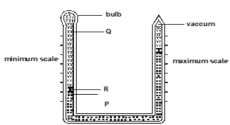
- Name the parts marked P, Q and R. (3 marks)
- The table below represents the rainfall and temperatures data of station X.
Month
J
F
M
A
M
J
J
A
S
O
N
D
Temp °C
28.9
29.7
30.3
29.9
29.7
29.2
28.4
28.7
29.6
30.1
29.2
28.7
Rainfall mm
9.0
8.0
21.0
49.0
25.0
9.0
20.0
10.0
4.0
10.0
17.0
11.0
- What is the annual range of temperature? (1 mark)
- Calculate the total rainfall of the station. (1 mark)
-
- What is rock metamorphism? (2 marks)
- Give three examples of chemically formed sedimentary rocks. (3 marks)
- The diagram below shows erosional features of the waves at the coast. Use it to answer question
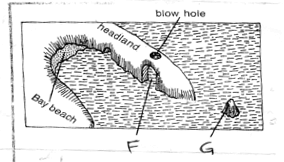
- Identify the features marked F and G. (2 marks)
- Give three submerged upland coasts (3 marks)
-
- Describe how lava-dammed lake are formed. (3 mrks)
- State two ways in which lakes influence the climate of the surrounding areas. (2mrks)
-
- Distinguish between soil profile and soil catena (2 marks)
- Give three soil forming processes. (3 mark)
SECTION B
Answer question 6 and any other two questions from this section
- Study the map of Kijabe 1:50000(sheet 134/3) provided and answer the following questions.
-
- State the title of the map (2 marks)
- Convert the ratio scale into statement scale (2mks)
- Identify the physical features found on grid source 4293
-
- What is the bearing of the cattle dip at Ewaso Kedong valley from grid reference 3193 (2 marks)
- What is the exact height of Kijabe hill at grid 2699. (2 marks)
- Explain three factors that influence settlement in the area covered by the map (6mks)
- Name two methods used to show relief. (2 marks
- Describe relief of the area covered by the map (5 marks
- Field study was carried out in Kijabe .
- State two types of vegetation the researchers identified. (2 marks)
- State two challenges they encountered. (2 marks)
-
-
-
- What is folding? (2 Marks)
- Name three fold mountains formed during Caledonian Orogeny. (3 Marks)
- State four characteristics of folded landscape. (4 Marks)
- The diagram below shows a type of fold.
- Name the type of fold. (1 Mark)
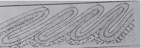
- Describe how the above type of fold is formed. (7 Marks)
- Name the type of fold. (1 Mark)
- Explain four effects of Fold Mountains on human activities. (8 Marks)
-
-
- Name three types of desert landscapes. (3 marks)
- Explain three ways through which the wind carries out erosion in the desert. (6 marks)
- With an aid of a well labeled diagram, describe how a rock pedestal is formed. (6 marks)
- State two factors which influence transportation of materials by wind in deserts. (2 marks)
- Explain four ways through which desert influence human activities. (8 marks)
- The diagram below represents underground featured in a limestone area. Use it to answer questions
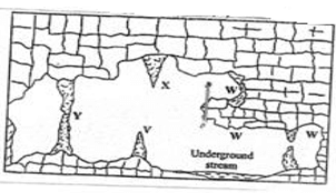
-
- Name the featured marked X, V and W. (3 mrks)
- Describe how the feature marked Y is formed (6 mrks)
-
- What is an artesian basin? (2 mrks)
- Explain three factors which influence the formation of features in limestone areas (6mrks)
- You are supposed to carry out a field study of an area eroded by water.
- Give three reasons why you would need a map of the area of study (2 mrks)
- Name two erosion features you are likely to identify during the field study (2 mrks)
-
-
-
- Define the term glaciation. (2 mrks)
- Name three types of glaciers. (3 mrks)
- Describe how the following features found in upland glaciated landscape are formed.
- U-shaped valley (5 mrks)
- Pyramidal peak (5 mrks)
- Explain three significances of upland glaciated features to human activities. (6 mrks)
- Suppose you were to carry out a field study of glaciated lowland.
- State two advantages of using oral interview to collect information during the field study. (2mrks
- Name two features found in glaciated lowland that you are likely to study. (2 mrks)
-
MARKING SCHEME
-
- Name the parts marked
- P - Mercury
- Q - Alcohol
- R - Metal index 3 marks
-
- Annual range of temperature
- 1.9°C 1 mark
- Total annual rainfall of the station
- 193mm 1 mark
- Annual range of temperature
- Name the parts marked
-
- What is rock metamorphism
- It is the change that occur when pre-existing rocks (sedimentary, igneous) are subjected to heat, pressure or both heat and pressure. 2 marks
- Three examples of chemically formed sedimentary rocks
- Travertine / Tufa
- Dolomite / dolostone
- Trona
- Gypsum
- Rock salt
- Limonite
- Haematite
- Flint /chert 3 marks
- What is rock metamorphism
- The diagram below shows erosional features of the waves at the coast. Use it to answer question
- Identify the features marked F and G. (2 marks)
- F – arc
- G- stack
- Give three submerged upland coasts (3 marks)
- Ria coasts
- Fiords/fjord coast
- Longitudinal/Dalmatian coast
- Identify the features marked F and G. (2 marks)
-
-
- Describe how lava-dammed lake are formed. ( 3 marks )
- Lava from erupting volcano flows downhill into a river valley
- It cools and solidifies filling the valley
- It forms a wall of solid lava which may block a river
- water accumulates behind this barrier to form a lake
Each point 1 mark ( 3 x 1 ) marks
- State two ways in which lakes influence the climate of the surrounding areas. (2 marks )
- Evaporation of lake water increases the relative humidity over the surrounding areas
- The moisture from lakes when picked by winds may lead to increased precipitation over the land.
- The presence of lake results in the development of pressure differences between land and lake breezes; the breezes may divert or reverse the prevailing wind.
- Winds from the lake to the land generally lower the temperatures over the land, making the land cooler.
Any three 2x1=2 marks
- Describe how lava-dammed lake are formed. ( 3 marks )
-
-
- Distinguish between soil profile and soil catena (2 marks)
- Soil profile is vertical arrangement of soil particles from the surface to the bed rock while soil catena is horizontal arrangement of soil particle along a slope from the top to the bottom
- Give three soil forming processes. (3 marks)
- Weathering
- Decomposition of organic mater
- leaching
- Distinguish between soil profile and soil catena (2 marks)
SECTION B : MAP WORK
- Study the map of kijabe 1:50000(sheet 134/3) provided and answer the following questions
-
- State the title of the map (2 marks)
- East Africa 1:50000(sheet 134/3)
- Convert the ratio scale into representative fraction (2mks)
- 1cm rep 0.5KM
- Identify the physical features found on grid source 4293
- River
- Forest
- State the title of the map (2 marks)
-
- What is the bearing of the cattle dip at Ewaso Kedong valley from grid reference 3193 (2 marks)
- 247 ±1
- What is the exact height of kijabe land at grid set 2699. (2 marks)
- 2660m
- Explain three factors that influence settlement in the area covered by the map
- Vegetation - forested areas are avoided
- Relief - steep slopes are avoided
- Transport - Dense settlement along transport lines e.g escarpment settlement
- Mention two methods used to indicate relief. (2 marks)
- Contuors
- Trigonometrical stations
- What is the bearing of the cattle dip at Ewaso Kedong valley from grid reference 3193 (2 marks)
- Describe relief of the area around by the map (5 marks)
- The area has steep slopes e.g. around kijabe hill
- The south western part of the area is gently sloping shown by spaced contours
- There is an escarpment on the southern part of the area covered by the map
- The highest point is 2660m above sea level which is to the North west.
- There are river valleys e.g. Ewaso Kedong
- Field study was carried out in Kijabe.
- State two types of vegetation the researchers identified. (2 marks)
- Thicket & forest, scrub
- State two challenges they encountered. (2 marks)
- Steep slopes difficult to climb.
- Fear of attack by wild animals in the forest.
- State two types of vegetation the researchers identified. (2 marks)
-
-
-
- What is folding? (2marks)
- Folding id the bending or distortion of crustal rocks due to compressional forces
- Name 3 fold mountains formed during the Caledonian Orogeny (3marks)
- Akwapin hills in Ghana
- Scandinavian highlands
- Scottish highlands
- What is folding? (2marks)
- State four characteristics of folded landscape (4marks)
- Has fold mountains
- The landscape has escarpments
- Has numerous depressions
- Made up of rolling plains
- The land scape has intermontane plateaus
- Intermontane basins
- it is made of valleys
- Has several ridges
- made up of Interlocking spurs
- The diagram below shows a type of fold
- Name this type of fold (1mark)
- Isoclinal fold
- Describe how this type of fold is formed (7marks)
- They are formed when the crustal rocks are subjected to intense compressional forces.
- Intense compressional forces on one side on the other side of crustal leads to folding of the crustal rocks
- Continued intensity of compressional forces on one side than on the other leads to formation of a series of close parallel folds.
- The folds are inclined towards the side with less compressional forces to form parallel inclined series of horizontal synclinonium and anticlinoriums
- This is called an isoclinal fold
- Name this type of fold (1mark)
- Effects of Fold Mountains on human activities (8marks)
- Fold mountains are sources of rivers that provide water for generation of H.E.P/ domestic use / Irrigation/ industrial use
- Fold Mountains are often forested and provide timber which is is used in building and construction industry/ medical.
- Some fold mountains have exposed valuable mineral deposits which are mined
- Fold Mountains are tourist attraction / snow covered slopes encourage sporting activities
- The windward slopes of some fold mountain create rain shadow effect which result into aridity, discouraging crop farming/ encourages livestock farming
- Some fold mountains may act as barriers to transport and communication lines difficult/ expensive
Any 4x2 (8marks)
-
-
- Stony deserts
Rocky deserts -
- Wind Abrasion - This is a process whereby carried materials / scrubs polishes desert rock surface hence further erosion.
- Deflation - This is the blowing away of loose materials like dust and fine particles by rolling them on the ground.
- Attrition - This is the wearing away of wind horne materials as it scrub against the rock surface.
The collision of the rocks against each other leads to further erosion of the rocks.
- Strong winds come in to contact with exposed mass of rocks with alternating layers of resistant and less resistant rocks. The less resistant layers are eroded more than the resistant layers. There is more wind erosion the base of the rock since the wind carries more materials for erosion at .Eventually an irregular mass of rocks with protruding layers of alternating hollows is formed rock pedestal
-
- Strength and speed of the wind
- Presence of obstacles.
- Presence of vegetation cover.
- Weather changes.
- Nature of the leads.
-
- Desert soil are dry thereby discourage settlement and practice of agriculture.
- Loess deposits transported by wind to far place are fertile and encourage agriculture.
- Solar radiation which is intensive in deserts is used to generate solar energy.
- Deflation hollows may contain water which is used for domestic and irrigation
- extensive bare surface of the deserts are used for testing weapons and car speed.
- Stony deserts
-
-
- The diagram below represents underground features in a limestone area. Use it to answer questions (a)
- X - Stalactites
- V - Stalagmite
- W - Care/ Cavern
-
- Solution of Calcium Carbonate trickles down slowly through the roof of a care or cavern. Solution droplets hang on the roof of a care.
- Water evaporates and calcium carbonate is precipitated. The precipitated calcium carbonate gradually builds downwards ones a period of fine as the solution continues to drip from the roof. This forms a stalactite.
- The solution splashes on the floor and water evaporates. The calcium carbonate in it precipitates and gradually builds upwards to form a stalagmite.
- Onetime, the stalactite join the stalagmite to form a pillar or column of feature Onetime, the stalactite join the stalagmite to form a pillar or column of feature. 6 x 1 = 6 marks
- The diagram below represents underground features in a limestone area. Use it to answer questions (a)
-
- It is a saucer shaped depression consisting of layer A permeable rock lying between two layers A impermeable rocks, with part of permeable rock exposed to the surface along the edges of the basin. 1 x 2 = 2 marks
-
- The surface rock must be thick limestone to allow solubility by rain water
- The rock should be hard and well jointed to allow water to percolate through the lines of weakness.
- The climate should be hot and humid to facilitate chemical reaction or weathering or carbonation.
- The water table should be far below the surface to allow the formation of the features (6 mks)
-
- Reasons why you would need map of the area of study
- To show the route to be followed during the study
- To show the extend or delimit the area of the study
- To show drainage features
- To be able to estimate distances
- To show the sever nature of terrain. Any 3 x 1 = 3 mks
- Two erosional features you would identify during the study
- Exposed rocks
- Ridges //clints
- Butes
- Mases
- Swallow holes
- Dolines
- Poljes
- Uvalas
- Gullies
- Wadia
- Strikes
- Dry river beds
- Earth pillars 1st 2 x 1 = 2 mks
-
- Building of gabions
- Construction of gabions
- Planting trees
- Planting of cover crops/mulching/strip farming
- Adapting farming methods that allow conservation of soil.
- Reasons why you would need map of the area of study
-
-
-
- Definition glaciation
- glaciation refers to the action of moving ice / process by which glaciers change the landscape on large scale
- Types of glaciers
- continental glacier
- valley glacier
- piedmont glacier
- cirque glacier
- niche glacier 3mks
- Definition glaciation
-
- Formation of V-shaped valley
- a pre-existing V-shaped valley is filled with ice / glacier
- the glacier erodes the V-shaped valley by abrasion and plucking process vertically and laterally
- the valley is deepened and widened by vertical erosion and lateral erosion
- the end spurs are truncated / trimmed / cut
- the ice melts away leaving a U-shaped valley 5mks
- Formation of a pyramidal peak
- initially ice collects in several hollows on the mountain side
- the ice exerts pressure on the hollows / cracks
- the plucking action of the ice enlarges the hollows so that more ice collects in them
- freeze thaw action of the ice leads to the expansion of cracks / hollows making them large basin which are called cirques
- nivation into the back walls of the hollows making them recede into the mountain side / the cirques recede toward each other
- steep sided, knife edged ridges called aretes are formed and they separate the cirques
- eventually three or more of these ridges / aretes converge at the top of the mountain forming a jagged peak called a pyramid peak / horn (surrounded by corries cirques) 5mks
- Formation of V-shaped valley
- Significance of upland glaciated features to human activities
- the warm valleys are suitable for farming / cultivation / glaciated uplands provide suitable grazing lands as they form fine benches on which summer pasture grow e.g. in Switzerland
- glacial uplands form magnificent features that encourage recreation / sporting activities e.g. mountaineering, ice skating, skiing /encourage tourism e.g. features like pyramidal peak, aretes etc.
- glaciated discourage human settlement hence the growth of the forest and therefore lumbering is practiced
- waterfalls formed by rivers in glaciated highlands provide suitable site for hydro-electric power production
- corries lakes / terms offer suitable areas for sports fishing
- the U-shaped valley / glacial through form natural route way e.g. roads / railway
- fiord coastlines harbours as well as good fishing grounds 6mks
-
- Advantages of using oral interview to collect information during the field study
- it gives first-hand information
- the interviewer can seek clarification on any ambiguities questions
- the interviewer create a good rapport with the interviewee
- the interviewer can elicit more information by initiating further discussion
- the method is useful in collecting information from people who cannotwrite and read 2 x 1 = 2mks
- Features found in a glaciated lowland
- depressions / glacial lakes
- rochemontonee
- crag and tail
- Drumlins
- boulder train
- kames
- terminal moraine
- till plain / glacial till / boulder
- outwash plain 2 x 1 = 2mks
- Advantages of using oral interview to collect information during the field study
-
Join our whatsapp group for latest updates
Tap Here to Download for 50/-
Get on WhatsApp for 50/-
Download Geography P1 Questions and Answers - Butula Sub-County Post Mock Exams 2021/2022.
Tap Here to Download for 50/-
Get on WhatsApp for 50/-
Why download?
- ✔ To read offline at any time.
- ✔ To Print at your convenience
- ✔ Share Easily with Friends / Students


