
INSTRUCTIONS TO STUDENTS
- This paper has two sections: A and B
- Answer ALL the questions in section A.
- In section B answer questions 6 and any other TWO questions.
- Candidates must answer the questions in English.
FOR EXAMINER’S USE ONLY
|
Section |
Questions |
Maximum Score |
Candidate’s Score |
|
A |
1 - 5 |
25 |
|
|
B |
6 |
25 |
|
|
|
25 |
|
|
|
|
25 |
|
|
|
Total Score |
100 |
|
|

QUESTIONS
SECTION A:
Answer all the questions in this section
- The diagram below shows the internal structure of the earth.
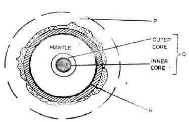
- Name the parts labelled P, Q and R. (3marks)
- State three characteristics of the inner core. (3marks)
-
- Give two local winds that are found in Kenya. (3 marks)
- State three conditions that are necessary for formation of dew. (3 marks)
- Explain how the following factors influence climate.
- Oceans currents (2marks)
- Forests (2marks)
-
- Define a lake (2marks)
- State two reasons why some rift valley lakes are fresh water. (2marks)
-
- Apart from desertification, name two other environmental hazards experienced in Kenya. (3 marks)
- State two causes of desertification. (2 marks)
SECTION B
Answer question 6 and any other two questions in this section
-
- Study the map of Kisumu East (1:50000) provided and answer the following questions.
- What is the bearing of the trigonometrical station at Grid reference 081980 from the rock
out crop at grid reference 071992. (1 mark) - Measure the length of the all – weather road (bound surface) B25 /3 from the junction at grid reference 968884 all the way to the edge of the area covered by the map in the east at GR 100816. (Give your answer in kilometers). (2 marks)
- Using a vertical scale of 1cm to represent 100metres, draw a Cross-section between
GR:040940 and 040990. (4 marks)
On it mark and name;- the escarpment. (1 mark)
- Power transmission line. (1 mark)
- Plantation. (1 mark)
- What is the bearing of the trigonometrical station at Grid reference 081980 from the rock
-
- Describe the relief of the area covered by the map. (4 marks)
- Explain how relief has experienced settlement in the area covered by the map. (2 marks)
- Citing evidence from the map, give three economic activities carried out in the area covered by the map other than crop growing. (3 marks)
- Students from the school at Mosongo (Grid square 0681) carried Out a field study of the course of the river Ombeyi.
- State three findings they are likely to have come up with. (3 marks)
- Give three advantages of studying rivers through fieldwork. (3 marks)
- Study the map of Kisumu East (1:50000) provided and answer the following questions.
-
-
- Describe the solar system. (2 marks)
- The local time at Manaul 60®. What is the time in Nairobi, 37®E? (3 marks)
-
- State five characteristics of the mantle in the interior of the earth. (5 marks)
- Outline the evidence which supports the theory of continental drift (4 marks)
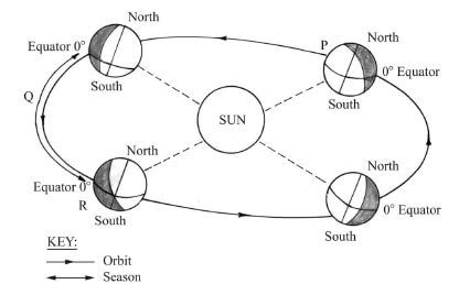
- The diagram below represents the revolution of the earth
-
-
-
- Distinguish between minerals and rocks. (2 marks)
- Describe the following characteristics of minerals:
- Colour. (2 marks)
- Tenacity. (2 marks)
- Hardness. (2 marks)
-
- What are sedimentary rocks? (2 marks)
- State three characteristics of sedimentary rocks. (3 marks)
- Explain two reasons why sedimentary rocks are widespread in the coastal plain of Kenya. (4 marks)
- Describe how the following sedimentary rocks are formed.
- Mechanically formed. (4 marks)
- Organically formed. (4 marks)
-
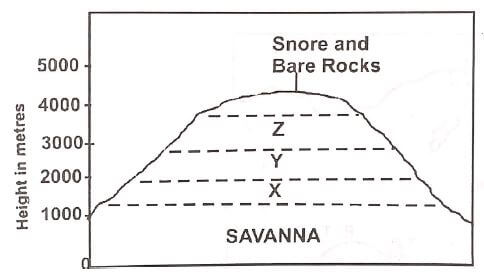
- The diagram below represents zones of natural vegetation on a mountain use it to answer questions (a)
-
- In your answer booklet, name the zones marked X, Y and Z (3 marks)
- Describe the characteristics of a tropical Savannah vegetation (6 marks)
- State two reasons why the mountaintop has no vegetation (2 marks)
- Explain three factors that have led to a decline of the natural grassland in Kenya. (6 marks)
- Suppose you were to carry out a field study on the relationship between vegetation and altitude
- State three objectives you would formulate for your study (3 marks)
- State three methods you would use to record the information collected during the field study (3 marks)
- Name two types of maps you would draw to present your findings (2 marks)
-
-
-
- Define soils. (2 marks)
- Give two main components of soils (2marks)
- Explain how the following factors influence soil formation;
- Parent material. (4 marks)
- Human activities. (2 marks)
- The diagram below shows a soil profile. Use it to answer question (i) and (ii).
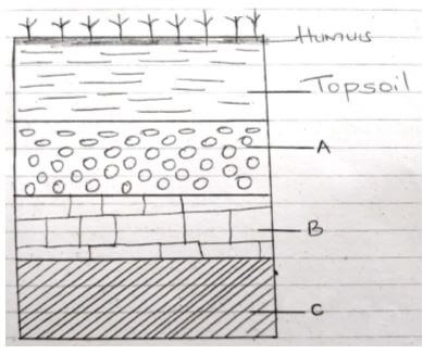
- Name the parts marked B and C. (2 marks)
- Describe the characteristics of the top soil (4 marks)
-
- Explain three causes of physical soil degeneration. (6 marks)
- State five ways of conserving soils (3 marks)
-
Join our whatsapp group for latest updates
Tap Here to Download for 50/-
Get on WhatsApp for 50/-
Download Geography Paper 1 Questions - Mumias West Pre Mock Exams 2023.
Tap Here to Download for 50/-
Get on WhatsApp for 50/-
Why download?
- ✔ To read offline at any time.
- ✔ To Print at your convenience
- ✔ Share Easily with Friends / Students