
INSTRUCTIONS
- This paper consists of two sections, A and B.
- Answer all questions in section A.
- Answer question 6 and any other two questions in section B.
- All answers must be written in English
SECTION A: 25 MARKS
-
- What is atmosphere (2marks)
- Name the three transition layers of the atmosphere (3marks)
-
- Explain two ways in which vegetation in the Nyika region of Kenya find adapted to the climatic condition experienced at the areas. (4marks)
- Describe two ways in which biological weathering takes place (2mks)
-
- What is the effect of international dateline on time? ( 2marks)
- Give the details of each of the following seasons;
- Equinox (1mark)
- Summer solstice (1mrks)
- Winter solstice (1marks)
-
- Explain how the presence of cold ocean current influences the climate of the adjacent coastlands. (4marks)
-
- What is folding? (2marks)
- Name one fold mountain in;
- North America (1mark)
- Africa (1mark)
- South America (1 mark)
SECTION B (75 MARKS)
- You have been provided with a map extract of Kisumu east sheet 116/2 1:5000, study the map and answer the following questions.
- Apart from the map provided, name the other two types of maps. (2marks)
- Calculate the area of Kisumu municipality. Give your answer in kilometers. (3marks)
- Describe the drainage of the area covered by the map. (4marks)
- What is the longitudinal extend of the area covered by the map. (2marks)
- Give the six figure grid reference of the trigonometric station near Muhoroni-Kisumu road.(2marks)
- Explain how relief has influenced settlement in the area covered by the map. (6 marks)
-
- Draw a cross section between grid reference 070940 and 070000. Use the scale 1cm to represents 250m. (Marks)
- On the cross section mark and name the all-weather roads (bound surface), Nyando escarpment and a hill. (6marks)
-
- Describe the following characteristic of minerals.
- Colour (2marks)
- Clearage (2marks)
- Hardness (2marks)
-
- Give two types of igneous rocks (2marks)
- Explain three conditions necessary for the growth of coral polyps (6marks)
- State four uses of rocks (4marks)
- You are planning to carry out a field study on the rocks within your school environment.
- Give two secondary sources of information you could use to prepare the field study. (2marks)
- State why you would need the following items during the field study.
- A fork jembe (1 mark)
- Carrier bag (1mark)
- Suppose during the field study you collect marble, sandstone and granite, classify each of this samples according to its mode of formation. (3marks)
- Describe the following characteristic of minerals.
-
- Give three processes that lead to formation of lakes. (2marks)
-
- Describe how Lake Victoria was formed. (4marks)
- Explain how Lake Victoria influences climate of the surrounding areas. (6marks)
-
- A part from Lake Magadi, name two other lakes within the rift valley in lakes that have high level of salinity. (2marks)
- Explain three causes of salinity in Lake Magadi. (6marks)
- Give four economic uses of lakes other than mining. (4marks)
-
- State three characteristics of desert soil. (3marks)
- Identify two factors that contribute to soil leaching. (2marks)
- Explain how each of the following factors influences the formation of soil;
- Nature of the parent rocks (2marks)
- Time (2marks)
- Topography (2marks)
-
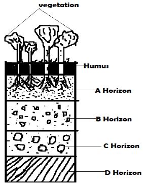
- Define soil profile. (2marks)
- The diagram below represent a well developed soil profile. State the characteristics of horizon A
- Explain four ways in which human activities contribute to loss soil fertility. (4 marks).
-
- Define underground water. (2 marks)
- Explain how the following factors influence availability of Underground water.
- Slope of the land (2mks)
- Vegetation cover (2mks)
-
- State three conditions that are necessary for the formation of an Artesian well. (3 mrks)
- State three problems that are associated with an artesian well. (3 marks)
-
- Differentiate between a Karst scenery and Karst region. (2 marks)
- The diagram below shows the underground features in limestone areas.
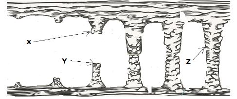
Identify the features marked X, Y and Z. (3 marks)
- Form four students of a school are planning to carry out a field study on a Karst landscape around their school.
- Name two surface features are likely to identify. (2 marks)
- Give three reasons why they needed a working schedule. (3 marks)
- Why was it necessary for them to divide into groups during their study? (3 marks)
MARKING SCHEME
-
- What is atmosphere (2marks)
- an envelope of gases held on the earth’s surface by force of gravity
- Name the three transition layers of the atmosphere (3marks)
- Tropopause
- Stratopause
- Mesopause
- What is atmosphere (2marks)
-
- Explain two ways in which vegetation in the Nyika region of Kenya find adapted to the climatic condition experienced at the areas. (4marks)
- Trees have long tap roots to tap water beneath
- Trees are umbrella shaped to provide shade that reduces the rate of evaporation around the stem
- Some plants have waxy needle like leaves to reduce loss of water through evaporation
- Some plants produce some seeds that are dormant for a long time and germinate when the rain falls.
- Some shed their leaves during dry season to reduce transpiration
- Name two ways in which biological weathering takes place. (2 marks)
- Through the action of plants
- Through the action of animals
- Through the action of people.
- Explain two ways in which vegetation in the Nyika region of Kenya find adapted to the climatic condition experienced at the areas. (4marks)
-
- What is the effect of international dateline on time? ( 2marks)
- On crossing the longitude towards the west a day is lost while a day is gained while crossing to the east.
- Give the dates of each of the following seasons;
- Equinox (1mark)
- 21st march 23rd September
- Summer solstice (1mrks)
- 21st June and 22nd December
- Winter solstice (1marks)
- 22nd December
- Equinox (1mark)
- What is the effect of international dateline on time? ( 2marks)
- Explain how the presence of cold ocean current influences the climate of the adjacent coastlands. (4marks)
- On shore winds on crossing a cold ocean current are cooled leading to premature condensation. On reaching the land they have a drying effect.
- In temperate areas in summer, cold current keep the coastlands cooler than placed on the same latitude
-
- What is folding? (2marks)
- The bending of crustal rocks due to earth movement.
- Name one fold mountain in;
- North America (1mark)
- rockie mountain
- Appalachians.
- Africa (1mark)
- Atlas.
- Cape ranges
- South America (1 mark)
- Andes Mountain. S
- North America (1mark)
- What is folding? (2marks)
SECTION B
- You have been provided with a map extract of Kisumu east sheet 116/2 1:5000, study the map and answer the following questions.
- Apart from the map provided, name the other two types of maps. (2marks)
- Atlas map
- Sketch map
- Calculate the area of Kisumu municipality. Give your answer in kilometers. (3marks)
- Full squares = 5 Incomplete = ½ x 16= 8 Area = 5+8 = 13km2
- Describe the drainage of The area covered by the map. (4marks)
- Many rivers and are permanent
- Area covered by map has a lake
- River Luanda Mayenya forms a dentritic drainage pattern.
- River Mayenya flows from North East to south west.
- What is the longitudinal extend of the area covered by the map. (2marks)
- 34°45` - 35°00`E
- Give the six figure grid reference of the trigonometric station near Muhoroni-Kisumu road. (2marks)
- 039832
- Explain how relief has influenced settlement in the area covered by the map. (6 marks)
- The scarp slope of Nyando escarpment is not settled because it is very steep and unsuitable for the construction of houses, roads and farming.
- There is scanty settlement on top of Nyando escarpment and hilly areas because they are unsuitable for building houses
- The lowland plains are densely settled because they are gentle sloping suitable for building houses.
-
- Draw a cross section between grid reference 070940 and 070000. Use the scale 1cm represents 250m. (Marks)
- On the cross section make and name the all-weather roads (bound surface), Nyando escarpment and a hill. (6marks)
- Apart from the map provided, name the other two types of maps. (2marks)
-
- Describe the following characteristic of minerals.
- Colour (2marks)
- All minerals have their specific characteristic colour. Some change colour when exposed e.g. gold is yellow, copper oxides are blue or green etc.
- Cleavage (2marks)
- Minerals have distinct cleavages. They have patterns in which they split or divide e.g. Mica split into thin layers. Plant and glass have distinctive fractures.
- Hardness (2marks)
- Minerals differ in hardness depending on their chemical constituencies and mode of formation e.g. tale is soft, quartz is moderately hard and diamond is the hardest.
- Colour (2marks)
-
- give two types of igneous rocks (2marks)
- intrusive/plutonic rocks
- Extrusive/hypabyssal rocks.
- Explain three conditions necessary for the growth of coral polyps (6marks)
- shallow water
- well oxygenated
- clear water i.e.
- warm water with temp 20°C - 29°C
- give two types of igneous rocks (2marks)
- State four uses of rocks (4marks)
- Valuable sources of minerals like gold
- Store underground water i.e. impermeable rocks
- Sources of income and employment
- Tourist attraction sites
- Making of artefacts e.g. soap stones
- Breakdown into fertile soils.
- You are planning to carry out a field study on the rocks within your school environment.
- Give two secondary sources of information you could use to prepare the field study. (2marks)
- Journals
- Maps
- Magazines
- Newspapers
- Extracts downloaded from the internet
- Statistical abstracts
- Books
- Periodicals
- Census reports
- State why you would need the following items during the field study; −
- a fork jembe - to dig the ground for accessing different rocks (1 mark)
- carrier bag - to carry or store rock samples for further studies (1mark)
- Suppose during the field study you collect marble, sandstone and granite, classify each of this samples according to its mode of formation. (3marks)
- marble - metamorphic
- sand stone - sedimentary
- granite - igneous
- Give two secondary sources of information you could use to prepare the field study. (2marks)
- Describe the following characteristic of minerals.
-
- Give three processes that lead to formation of lakes. (2marks)
- Crast warping /tilting
- Volcanic activity
- Erosion by wind/ river/ glacier
- Deposition by water/ice/river
- Human activity/ mass wasting
-
- Describe how Lake Victoria was formed. (4marks)
- formed when the earth surfaces down warped and tilted
- shallow depression formed. Areas around the depression underwent uplifting. The uplift reversed the direction of rivers such as River Kagera. Water from the river and the rain filled the depression forming Lake Victoria.
- Explain how Lake Victoria influences climate of the surrounding areas. (6marks)
- Heavy rainfall due to moisture from the lake.
- High temperature due to low altitude caused by the depression.
- The lake causes reversal of local winds in the surrounding areas
- Evaporation from the lake leads to high relative humility in the area
- The lake encourages of the formation of lake breezes which have cooling effects on the shore of Lake Victoria
- Describe how Lake Victoria was formed. (4marks)
-
- A part from Lake Magadi, name two other lakes within the rift valley in lakes that have high level of salinity. (2marks)
- L. Natron
- L. Bogoria
- L. Elementaita
- Explain three causes of salinity in Lake Magadi. (6marks)
- Lack of underground outlet to the lake thus mineral salts accumulate in its water.
- Presence of salt bearing on the lake leads to mineral salts dissolving in the water in the lake increasing salinity.
- High temperature in the area leads to high evaporation from the lake leading to high concentration of mineral salts in the water.
- Mineral salts are deposited in the lake by surface runoff/rivers increasing the concentration of salt in the water.
- Underground seepage of water that is rich in mineral salts, add the salts in the lake
- A part from Lake Magadi, name two other lakes within the rift valley in lakes that have high level of salinity. (2marks)
- Give four economic uses of lakes other than mining. (4marks)
- Sources of fish
- Irrigation
- H.E.P production
- Source of rivers
- Tourist attraction
- Building materials i.e. sand
- Source of water
- Give three processes that lead to formation of lakes. (2marks)
-
- State four characteristics of desert soil. (3marks)
- they are thin/shallow
- they are Stoney/sandy
- they lack humus
- they are saline
- they are loose in feature
- Identify two factors that contribute to soil leaching. (2marks)
- high rainfall
- topography
- nature of the soil
- Describe how the following factors influence the formation of soil.
- Nature of the parent rock (2 marks)
-
Rock minerals determine the fertility and chemical characteristics of the soil.
-
Hard rocks weather slowly taking long time for formation soil/soft rocks weather faster to form soil.
-
Rock texture determines soil structure, such that coarse grained rocks from coarse grained soil/fine grained rocks form fine soils.
-
- Time (2mks)
-
Where soil formation processes take a short duration the soils are generally immature.
-
Where the processes has taken a long period of time the soils are well developed/mature
-
Young soils retain the characteristics of the parent rock because they have not been exposed to the factors that may cause change.
-
Mature soils may not display the characteristics of the parent rocks
-
Long exposure the factors may cause change
-
- Topography (2 marks)
- Gentle slopes form deep, well drained and mature soils having clear profile.
- Steep slopes are heavily eroded forming thin and immature soils.
- Valley bottoms have deposition of weathered rock materials forming deep soils.
- Flat areas are waterlogged forming poorly drained soils
- Nature of the parent rock (2 marks)
-
- Define soil profile. (2 marks)
- The vertical arrangement of soil in layers/horizons from the earth’s surface to the bedrock.
- The diagram below represents a well-developed soil profile. State the characteristics of horizon A. (4 marks)
- Have intense chemical and bacterial activities.
- Dark in colour
- Contain humus
- Fine textual soil
- Has two soil layers.
- Zone of eluviation/leaching occurs
- Define soil profile. (2 marks)
- Explain four ways in which farming practices may lead to loss of soil fertility. (8 marks)
- Overgrazing leads to removal of vegetation (over exposing the soil to agents of erosion removing the top fertile soil)
- Continuous irrigation cause soil nutrients to be leached making the top soil deficient of soluble minerals.
- Frequent ploughing weakens the soil structure making the soil easily eroded by agents of erosion.
- Ploughing up and down the slope creates channels for surface run-off which encourage soil erosion.
- Shifting cultivation makes the abandoned land open to erosion and loss of soil fertility.
- Monoculture makes soil nutrients exhausted.
- State four characteristics of desert soil. (3marks)
-
-
- Define underground water. (2 marks)
- It is the water that exists beneath the earth’s surface in pore spaces in soils and rocks.
- Explain how the following factors influence availability of underground water. (2 marks)
- Slope of the land - There is more underground water in flat and gently sloping areas because rain water has ample time to infiltrate while steeply sloping area have little underground water.
- Vegetation cover - Areas with thick vegetation have more underground water because plants break the speed of surface run-off of rain water, while areas with scanty vegetation cover have little underground water.
- Define underground water. (2 marks)
-
- State three conditions that are necessary for the formation of an artesian well. (3 marks)
- Aquifer to be sandwiched between impermeable rocks to prevent evaporation and percolation.
- Aquifer to be exposed in a region which is a source of water e.g. rainy area or lake.
- Mouth of the well must be at a lower level than the intake area to develop hydraulic pressure to force water out.
- Aquifer to dip from a region of water intake and rock layers must form a bread syncline or basin.
- State three problems that are associated with an artesian well. (3 marks)
- Water may be hot due to high temperatures.
- Water may be salty due to percolation through the salty water rocks.
- Water may fail to come out naturally when it is drawn faster than it is being replaced.
- State three conditions that are necessary for the formation of an artesian well. (3 marks)
-
- Differentiate between a Karst scenery and Karst region. (2 marks)
- A karst region is where surface and the ground is covered with limestone rock while karst scenery are the unique features in karst region that are formed due to action of water.
- The diagram below shows underground features in limestone areas.
Identify the features marked X, Y and Z. (3 marks)- Y - Stalagmite
- X - Stalactite
- Z - Limestone pill
- Differentiate between a Karst scenery and Karst region. (2 marks)
- Form four students of a school are planning to carry out a field study on a Karst landscape near their school.
- Give two surface features in a Karst region that they identified. (2 marks)
- Grikes and clints
- Swallow holes
- Dry valleys
- Karst window
- Dolines/dolina
- Uvala
- Polje
- Limestone gorges
- Karst Bridge
- State three reasons why they needed a working schedule. (3 marks)
- To provide an estimate of total time required for study.
- To ensure all important areas are covered and none is forgotten.
- Provides a framework to guide researcher’s to stick to the topic.
- It indicates the specific time when each activity should take place.
- Why was it necessary for them to divide into groups during their study? (3 marks)
- To create order during the study.
- To ease congestion in the area of study.
- To help participants collect data within the time given.
- To reduce fatigue among participants.
- Give two surface features in a Karst region that they identified. (2 marks)
-
Join our whatsapp group for latest updates
Tap Here to Download for 50/-
Get on WhatsApp for 50/-
Download Geography Paper 1 Questions and Answers - Lugari Constituency Joint Pre Mock Exams 2023.
Tap Here to Download for 50/-
Get on WhatsApp for 50/-
Why download?
- ✔ To read offline at any time.
- ✔ To Print at your convenience
- ✔ Share Easily with Friends / Students