
INSTRUCTIONS
- This paper consists of two sections, A and B.
- Answer all questions in section A.
- Answer question 6 and any other two questions in section B.
- All answers must be written in English
SECTION A
Answer all the questions in this section.
-
- Why is Geography a unique subject? (2 marks)
- Give three branches of human Geography (3 marks)
-
- Differentiate between a forest and forestry. (2 marks)
- State three factors that have hindered exploitation of equatorial rainforest in Africa. (3 marks)
-
- Define mining (2 marks)
- Name three exotic breed of dairy cattle reared in Kenya (3 marks)
-
- Name two major imports from Europe to Kenya. (2 marks)
- State three problems facing developing countries in international trade. (3 marks)
-
- State two factors which have led to the growth of Mombasa as a major sea port (2 mks)
- Name a town in Kenya where each of the following industries is located. (3 marks)
- Oil refinery -
- Paper manufacturing -
- Motor vehicle assembly -
SECTION B
Answer question 6 and any other two questions from this section.
-
- The table below shows the area under the horticultural crops in Kenya between 2000 and 2002. Use it to answer the questions below:
crop 2000 2001 2002 cabbages 320 340 380 tomatoes 360 360 330 onions 340 320 360 oranges 380 380 400 - Name the crop that has the highest production within the period(1mk)
- Explain THREE reasons why horticultural farming is increasingly becoming important to Kenyan farmers. (6mks)
- Using 1cm to represent 10000 tonnes, draw a compound bar graph to present the data above. (6mks)
- Give FOUR features of horticultural farming. (4mks)
-
- Describe any THREE physical factors favoring maize caltivation in Kenya. (6mks)
- A part from Trans-Nzoia county, name any other two counties where maize is grown on large scale, in Kenya (2mks)
- The table below shows the area under the horticultural crops in Kenya between 2000 and 2002. Use it to answer the questions below:
-
-
- Define the term population density. (2 marks)
- Identify any three reasons for carrying out population census in Kenya recently. (3 marks)
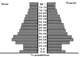
- The pyramid shown below shows population structure for a country. Use it to answer question (a).
- Identify any two countries that have population structures similar to one shown. (2 marks)
- Identify any four characteristics associated with the population of the country. (4 marks)
- Explain three problems that are likely to face a country experiencing a high population growth rate. (6 marks)
- Describe four ways in which the population of Kenya differs from that of Sweden. (8 marks)
-
-
-
- Differentiate between land reclamation and land rehabilitation (2 marks)
- Identify three methods of land reclamation in Kenya (3 marks)
-
- State four physical factors that influenced the location of Mwea Tebere irrigation scheme (4marks)
- Explain four problems facing Mwea Tebere irrigation scheme (8 marks)
-
- Name two major land reclamation projects that were undertaken in Netherlands (2 mark)
- Give three differences between land reclamation in Kenya and the Netherlands. (6 marks)
-
-
-
- What is flooding (2mks)
- Name THREE rivers that cause large scale flooding, (3mks)
- State FOUR ways in which people are affected by floods. (4mks)
-
- What is pollution ? (2mks)
- Explain three ways in which farming activities contribute to water pollution. (6mks)
-
- Explain THREE measures taken by the government to manage and conserve the environment. (6mks)
- Name two Non –Governmental organization (NGOs)concern with environmental conservation. (2mks)
-
-
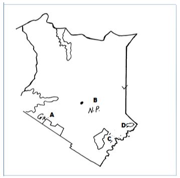
- Using the map below, name the following National parks and game reserves.
A,B,C and D . (4mks)
-
- List four problems facing wildlife conservation in Kenya. 4mks
- Give three reasons why there has been an increase in the tourist visiting Kenya (2003-2006) (3mks)
- State two characteristics of eco-tourism (2mks)
- Explain the measures the Kenya government is undertaking to improve domestic tourism (6mks)
- Explain three physical factors favouring tourism in Switzerland (6mks)
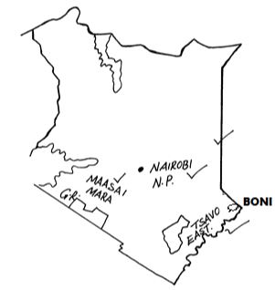
- Using the map below, name the following National parks and game reserves.
MARKING SCHEME
SECTION A
Answer all the questions in this section.
-
- Uniqueness of geography as a subject
- It relates with other disciplines in relation to human and physical phenomena (2mks)
- Branches of human geography
- Medical, economic, agricultural, historical geography etc. avoid examples such as agriculture, mining , forestry, fishing, trade and land reclamation ( any 2 x 1 = 2mks)
- Uniqueness of geography as a subject
-
- Differentiate the difference between a forest and forestry. (2 marks)
- A forest is a continuous growth of trees and under growth covering extensive land while forestry is the science of developing and managing forests including cultivating them.
- Hinderance in exploitation of equatorial
- Differentiate the difference between a forest and forestry. (2 marks)
-
- Define mining (2 marks
- Extraction of valuable minerals from the earths crust
- Name three exotic breed of dairy cattle reared in kenya (3 marks)
- Guerney
- Alderney
- Swiss brown/ brown swiss
- Fleck-vieh/simmental
- Jersey
- Aryshire
- Fresian/holstein (Any 3x1=3mks)
- Define mining (2 marks
-
- Name two major imports from Europe to Kenya. (2 marks)
- Machinery,
- Textiles,
- Fertilizers,
- Automobiles,
- Capital equipment,
- Pharmaceutical production,
- Steel,
- Electronics.
- State three problems facing developing countries in international trade. (3 marks)
- Political instability/civil wars in some of the countries within the region discourage/ hinder trade e.g. in southern Sudan.
- The similarity of the goods produced results into competition and therefore inadequate market for the goods.
- Political instability/civil wars in some of the countries discourage foreign investors from investing in some of the countries.
- Inadequate capital to establish industries/add value to agricultural produce as well as low standards of living / incomes discourages trade.
- Many of the countries still maintain historical ties with their former colonial masters / trade links.
- Inadequate/ poor means of transport and communication hinder trade as the cost of transport and communication is high.
- Corruption in many African countries discourages trade as the cost of doing business becomes high.
- Name two major imports from Europe to Kenya. (2 marks)
-
- FOUR factors leading to growth to Mombasa (4marks)
- It has a deep harbor
- It has a well sheltered harbor
- It has a large/rich hinterland
- Its located at a strategic point on the East African coast
- Its well linked ko the interior by railway, road an air transport
- Early settlement le to the growth and expansion of the town.
- Early trade in the region led to its growth.
- Name a town in Kenya where each of the following industries is located. (3 marks)
- Oil refinery - Mombasa.
- Paper manufacturing - Webuye.
- Motor vehicle assembly - Nairobi / Mombasa/ Thika.
- FOUR factors leading to growth to Mombasa (4marks)
SECTION B
Answer question 6 and any other two questions from this section.
-
-
- Oranges (1mk)
-
- High income
- Requires a small piece of land.
- Less labour as compared to others.
- Availability of market in urban centres.
- Improved transport and communication. Well explained (3x2=6mks)
- Compound bar graph
- title 1mk
- origin 1mk
- variable 3mks
- trend 1mk
-
- Availability of advanced technology.
- Developed infrastructure e.g. roads, ports etc.
- Availability of advanced labour.
- Readily available market
- Well drained and fertile soil.
- Good management
- Availability of capital. (1x4=4mks)
-
-
- Temperatures ranging from 18°C to 27°C/moderate temperatures
- 20 weeks free of frost to allow maturity and harvesting
- Moderate rainfall / 600-1100mm for optimum growth
- Well drained/red volcanic/loamy soils
- Undulating topography to allow use of machinery. (well explained 3x2=6mks)
-
- Narok
- Nakuru
- Uasin Gishu
- Laikipia
- Bungoma
- Vihiga
-
-
-
-
- Define the term population density. (2 marks)
- This is the number of people found within a given area (sq.km)
- Identify any three reasons for carrying out population census (3 marks)
- To serve as a basis for planning and policy making.
- To help in planning for education / training facilities
- To plan for future social amenities provision.
- To reveal the population growth rate.
- To reveal the dependency ratio.
- To reveal the occupational level hence plan for job creation. (3x1=3mks).
- Define the term population density. (2 marks)
- The pyramid shown below shows population structure for a country. Use it to answer question (a).
-
- Identify any two countries that have population structures similar to one shown. (2 marks)
- Sweden
- Canada
- New Zealand
- Japan (any 2x1=2 marks)
- Identify any two countries that have population structures similar to one shown. (2 marks)
- Identify any four characteristics associated with the population of the country.(4 mks)
- The number of male and female population is almost equal at all levels
- From 0- 14 years, the population is low
- From 14 -44 the population is high
- The ageing population is low
- The population has high life expectancy
- The dependency ration is low
- The population has a low birthrate
- The population has a low death rates (any 4x1 =4mks)
- Explain three problems that are likely to face a country experiencing a high population growth rate. (6 marks)
- There is likely to be high unemployment rate/ rate of creation of job opportunities would increase at a lower rate than increasing number of job seekers/ low standard living.
- There may be limited government resources to provide adequate social amenities/inadequate social facilities
- It may lead to a high dependency ratio which will slow down the economic growth
- Strain on natural resources/ scarcity of land which would lead to landlessness and land fragmentation
- There would be inadequate food production/ food shortages
- Describe four ways in which the population of Kenya differs from that of Sweden. (6 marks)
- The population of Kenya has a large number of young people below 20 years of age while Sweden has an ageing population.
- Kenyans population has a lower life expectancy while Sweden has a lower life expectancy.
- Population birth rate in Kenya is high while it is low in Sweden
- The fertility rate in Kenya is high while in Sweden it is low
- The population growth rate is high in Kenya and low/negative in Sweden.
- A high percentage of the population in Kenya live in rural areas while in Sweden most people live urban areas (the difference must be complete) (any 3 x2 =6mks)
-
-
-
- Differentiate between land reclamation and land rehabilitation (2 marks)
- Land reclamation is the process of converting less productive land into a more productive state for agricultural or settlement purposes while land rehabilitation is the process of restoring degraded/impoverished/damaged land back to its former useful state.
- Identify three methods of land reclamation in Kenya (3 marks)
- Irrigation
- Draining of swamps
- Afforestation
- Control of tse tse flie
- Differentiate between land reclamation and land rehabilitation (2 marks)
-
- State four physical factors that influenced the location of Mwea Tebere irrigation scheme (4marks)
- Gently sloping land which permits flow of water by gravity hence reducing the costs of pumping water to the fields
- Presence of clay soil/ black cotton soils which retain water for longer use by crops
- Presence of river/ reservoirs/ lake which provide regular water supply/ permanent/ constant making it possible to irrigate land throughout the year
- High temperatures throughout the year which allows multiple cropping continuous farming activities throughout the year
- Availability of large tracts of land makes the project viable
- Sparsely populated land reduces cost of resettlement / Provides land for large scale farming
- Explain four problems facing Mwea Tebere irrigation scheme (8 marks)
- Siltation of canals/ pipes/ reservoirs making the cost of operations high
- High rate of evaporation
- Salinization of the soil leading to deterioration of soils hence lowering the yields
- Presence of pests e.g. the quelea quelea birds which destroy grains hence lowering yields to farmers
- Clogging up of canals by water weeds which reduces the volume of water in canals
- Stagnant water leading to waterborne diseases e.g. bilharzias/malaria which affect productivity of the farmers
- Fluctuating regimes of rivers/ water for irrigation which lead to water shortages during the dry season hence reducing yields
- Poor marketing strategies leading to low prices for rice hence low income from the crop
- Land tenure problems due to absence of land titles which has limited the development in the plots allocated
- Mismanagement of mills/National irrigations Board leading to the delayed payments hence demoralizing the farmers
- Expensive farm inputs/ inadequate capital hence limited profits/limited expansion
- State four physical factors that influenced the location of Mwea Tebere irrigation scheme (4marks)
-
- Name two major land reclamation projects that were undertaken in Netherlands (2 marks)
- Zuyder zee project
- Delta plan
- Give three differences between land reclamation in Kenya and the Netherlands.(6mrks)
- In Kenya, the area that is reclaimed is relatively small while the areas reclaimed in the Netherlands are large.
- In Kenya, land is mainly reclaimed from swamps and marginal areas while in Netherlands reclamation is from sea.
- In Kenya the methods used for draining water form marshy areas is digging of canals/ditches while in the Netherlands the methods are advance/use of wind pumps to drain sea water from the polders.)
- In Kenya irrigation is used as reclaiming dry areas while irrigation in the Netherlands is used to lower the salinity of the soil in the claimed lands.
- In Kenya the methods of land reclamation are simple like digging canals/ditches to drain water from lad while in the Netherlands the method used are highly advanced like reclaiming land from the sea/creation of polders.
- Furrow/ridges protect the reclaimed land from invasion by the sea. (Any 3 x 2 = 6marks)
- Name two major land reclamation projects that were undertaken in Netherlands (2 marks)
-
-
-
- Flooding refers to the periodic rise in the level of water in river, lakes or oceans which causes overflow is normally dry lands. 1x2=2mks
- River causing floods in Kenya any 3x1=3mks
- R. Tana
- R. Nyando
- R. Kuja
- R. Nzoia
- How people are affected by flood 4x1=4mks
- Causes displacement of people / settlement.
- Causes destruction of property/ deaths
- Leads to outbreak of water borne diseases.
- Disrupts farming activities thereby leading to food shortages or famine.
- Causes destruction of transport and communication facilities making areas inaccessible.
-
- Pollution refers to the introduction of harmful substances into the environment/ contamination of the environment with materials that interfere with human health or quality of life.
- How farming activities contribute to pollution. 4x2=8mks
- Agro chemicals used such as DDT used in agriculture are caused by running water into rivers and lakes causing water pollution.
- Remains of fertilizers such as nitrates and phosphates are also carried by running water into rivers.
- Poor farming methods such as ploughing along contours and along river banks lead to soil erosion. The soil is deposited in water causing pollution.
- When animals from farms are slaughtered the slaughter houses discharge blood and the wastes into rivers causing water pollution
-
- Measures taken to manage and conserve the environment. 4x2=8mks
- Afforestation and re- Afforestation programmes mainly in arid and semi arid lands.
- Encouraging agro forestry
- Protection of natural resources by limiting the use of pesticides and other toxic chemicals. This is also done through creation of national parks and game reserves.
- Public awareness campaigns having been carried out through the provincial administration, schools and other bodies.
- Enactment of laws which govern management and conservation of the environment.
- NGOs concerned with environment
- Green belt movement
- ICRAF
- CARE Kenya
- SIDA
- Measures taken to manage and conserve the environment. 4x2=8mks
-
-
- Outline 1mk
- A - Maasai Mara 1mk
- B - Nairobi N.P 1mk
- C -Tsavo East 1mk
- D - Boni 1mk
-
-
- Poaching
- Wildlife-human conflict
- Pollution of the environment e.g. sewage disposal from the lodges
- Population increase which put pressure on land
- Off road driving by tourist vehicles
- Drought
- Bush fires
- Overgrazing
- Inadequate capital
- Pest and disease control 4x1=(4mks)
-
- Improved security in the parks/air ports/ introduction of tourists police
- Tourist promotion in foreign countries by the Kenya Tourist Board (KTB)
- Political stability in the country
- Encouragement of domestic tourism by various tourist agencies
- The government has set up mechanisms to combat terrorism 3x1=(3ks)
-
-
- Characteristics of eco-tourism 2x1=(2mks)
- Tourists walks through footpaths instead of driving to the tourists attraction sites
- Telescope viewing of animals from a distance to avoid disturbing them
- Building camping sites instead of big tourists hotels to avoid putting pressure on resources which animals depend on
- Allow only particular types of vehicles to be used in some national parks and game reserves especially those that does not produce a lot of noise
-
- Tourist attraction promotions by the government through various agencies
- Favourable accommodation rates being offered in hotels and lodges during the off peak tourist season
- The gate fees to the parks and game reserves are lower for the local people
- Provision of free entry to the parks during some special days in an year.
- Provision of free transport to paying Kenyan citizens to the parks e.g. in Lake Nakuru National park 2x3=(6mks)
- Characteristics of eco-tourism 2x1=(2mks)
-
- Magnificent mountain scenery-Alps mountains with its peaks, hanging valleys, water falls and ice capped peaks.
- Glaciated lakes-There are numerous lakes on the Swiss plateau e.g. Lugano, Maggiore, Zurichsee. These lakes are used for sport-fishing, boating, swimming
- Climate-Switzerland has a double climate i.e. summer and winter summer attractions include, swimming, viewing ice-capped pearks, sunbathing. In winter there are winter sports such as skiing and ice-skating.
- Rivers-Switzerland has numerous rivers which are used in HEP production use in transport and hotels
- Suitable location-Switzerland is centrally situated in Europe. This makes the country relatively close to the industrialised countries which are the major source of its tourists.
Join our whatsapp group for latest updates
Tap Here to Download for 50/-
Get on WhatsApp for 50/-
Download Geography Paper 2 Questions and Answers - Lugari Constituency Joint Pre Mock Exams 2023.
Tap Here to Download for 50/-
Get on WhatsApp for 50/-
Why download?
- ✔ To read offline at any time.
- ✔ To Print at your convenience
- ✔ Share Easily with Friends / Students