
INSTRUCTIONS
- This paper two sections: A and B
- Answer all the questions in section A.
- In section B answer question 6 and any other two questions.
- All answers must be written in the foolscaps provided.
- Candidates must answer the questions in English.
SECTION A
- The diagram below shows some weather station instruments.
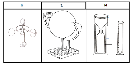
- Identify the instruments marked K, L and M. (3 marks)
- Outline two modern methods of weather forecasting. (2 marks)
-
- Give the two main movements of the earth. (2 marks)
- State three reasons why the interior of the earth is very hot. (3 marks)
- The diagram below show the occurrence of an earthquake
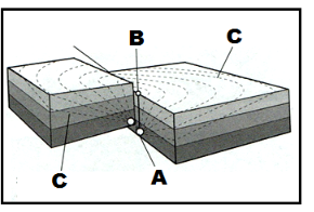
- Name the parts marked A, B and C (3marks)
- List two scales used to measure the magnitude of an earthquake. (2 marks)
- State five characteristics of coniferous forests. (5 marks)
-
- What is soil catena? (2 marks)
- State three factors that influence soil colour. (3 marks)
SECTION B
- Study the map of Oyugis (1:50, 000, sheet 130/1) provided and use it to answer the following questions.
-
- Identify two relief features at grid square7342. (2 marks)
- Measure the distance of road E 212 from its junction with road C 18 to the junction at grid square 7542. Give your answer in kilometres. (2 marks)
- Determine the six figure grid reference of Kitweru School. (2 marks)
-
- What is the vertical interval of the map? (1 mark)
- Determine the bearing of a jaggery factory at grid reference 788237 from a church at grid reference 806188.
(2 marks)
-
- Draw a square 10cm by 10cm to represent the region east of easting 85 from northing 30 to northing 40. On the square, mark and name.
- Kodera forest.
- Oriang’ hill
- A district boundary.
- All weather road-bound surface.
- A seasonal swamp (6 marks)
- What is the scale of the sketch that you have drawn? (1 mark)
- Draw a square 10cm by 10cm to represent the region east of easting 85 from northing 30 to northing 40. On the square, mark and name.
-
- Citing evidence from the map, identify four crops grown in the area covered by the map. (4 marks)
- Describe the distribution of settlement in the area covered by the map. (5 marks)
-
-
-
- What is a mineral? (2 marks)
- Give three ways used to classify rocks. (3 marks)
-
- Describe how igneous rocks are formed. (5 marks)
- List three examples of mechanically formed sedimentary rocks.(3 marks)
- Explain three types of rock metamorphism. (6 marks)
- Suppose you were to carry out a field study on rocks in the area surrounding your school
- State three characteristics that you would look for while identifying different rock types (3marks)
- State three follow up activities for the field study. (3marks)
-
-
-
- Differentiate between faulting and folding. (2 marks)
- Name five features formed as a result of faulting. (5 marks)
- The world map below shows the location of some fold mountains. Use it to answer question (a) (i)
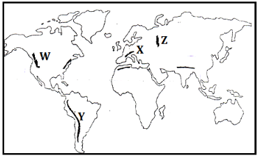
- Identify the fold mountains marked W, X, Y and Z (4marks)
- Citing relevant examples, explain how Fold Mountains were formed according to the plate tectonics theory. (6 marks)
- Explain the effects of Fold Mountains on the following
- Transport. (2 marks)
- Agriculture. (2 marks)
- Tourism. (2 marks)
- Mining. (2 marks)
-
-
- Give three examples of West coast deserts. (3 marks)
-
- Apart from rock pedestals, name four other features formed due to wind erosion in arid regions. (4 marks)
- With the aid of well labelled diagrams, describe how a rock pedestal is formed. (7 marks)
- Explain four factors that influence the rate of wind transport. (8 marks)
- State three negative influence of desert features. (3 marks)
-
-
- What is a lake? (2marks)
- Givethree processes that lead to formation of Lakes. (3marks)
- Describe how Lake Victoria was formed (6marks)
- Explain three factors why some Lakes in the Rift Valley in Kenya are saline. (6marks)
- Explain four ways in which lakes influence the climate of the surrounding areas. (8marks)
-
MARKING SCHEME
SECTION A
- The diagram below shows some weather station instruments.
- Identify the instruments marked K, L and M. (3 marks)
- K - Anemometer
- L – Sunshine recorder
- M – Rain gauge
- Give two modern methods of weather forecasting. (2 marks)
- Use of artificial satellites.
- Use of a radiosonde.
- Use of computers.
- Use of an aero sound.
- Use of weather radars.
- Identify the instruments marked K, L and M. (3 marks)
-
- Give the two main movements of the earth. (2 marks)
- Rotation of the earth
- Revolution of the earth
- State three reasons why the interior of the earth is very hot. (3 marks)
- The original heat at formation is still being retained.
- Due to the weight of overlying materials.
- Due to the breakdown of radioactive elements.
- Give the two main movements of the earth. (2 marks)
- The diagram below show the occurrence of an earthquake
- Name the parts marked A, B and C (3marks)
- A – Seismic focus
- B – Epicentre
- C – Shock waves
- List two scales used to measure the magnitude of an earthquake.(2 marks)
- Richter scale
- Moment magnitude scale
- Name the parts marked A, B and C (3marks)
- State five characteristics of coniferous forests. (5 marks)
- Tree species are softwoods
- Most tree species are evergreen.
- The trees have a big portion of stem compared to the leaves.
- Trees have a conical shape to allow snow to slide off easily.
- Trees have needle like leaves.
- Trees occur in big pure stands.
- Trees have a thick bark which is waxy to protect them from winter cold.
- The forest floor has very little or no undergrowth due to long winters.
- Trees have wide shallow roots to utilize moisture from the top soil.
- Trees are tall with flexible trunks to prevent breaking during strong winds.
-
- What is soil catena? (2 marks)
- Soil catena refers to the sequence variation of soil derived from the same parent material down a slope from top to bottom.
- State three factors that influence soil colour. (3 marks)
- The chemical composition of the soil particles
- The amount of organic matter present in the soil.
- The type of parent material from which the soil has developed.
- The drainage of the area in which the soil is found.
- What is soil catena? (2 marks)
SECTION B
- Study the map of Oyugis (1:50, 000, sheet 130/1) provided and use it to answer the following questions.
-
- Identify two relief features at grid square7342. (2 marks)
- Hills
- Steep slope
- A river valley
- A pass
- Measure the distance of road E 212 from its junction with road C 18 to the junction at grid square 7542. Give your answer in kilometres. (2 marks)
- 7.9 km (accept 7.8 km or 8.0 km)
- Determine the six figure grid reference of Kitweru School. (2 marks)
- 748174
- Identify two relief features at grid square7342. (2 marks)
-
- What is the vertical interval of the map? (1 mark)
- 50 feet
- Determine the bearing of a jaggery factory at grid reference 788237 from a church at grid reference 806188.
(2 marks)- 3400(accept 3390 or 3410)
- What is the vertical interval of the map? (1 mark)
-
- Draw a square 10cm by 10cm to represent the region east of easting 85 from northing 30 to northing 40. On the square, mark and name.
- Kodera forest.
- Oriang’ hill
- A district boundary.
- All weather road-bound surface.
- A seasonal swamp (6 marks)
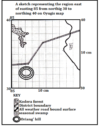
- What is the scale of the sketch that you have drawn? (1 mark)
- 1:100,000
- Draw a square 10cm by 10cm to represent the region east of easting 85 from northing 30 to northing 40. On the square, mark and name.
-
- Citing evidence from the map, identify four crops grown in the area covered by the map. (4 marks)
Crop Evidence Coffee presence of coffee factories Sugarcane presence of a jaggery factory and sugar research station Cotton presence of cotton stores Maize presence of flour mills - Describe the distribution of settlement in the area covered by the map. (5 marks)
- There are more settlements on the eastern part of the map than in other parts.
- There are clusters of settlements at shopping centres or markets
- Kodera forest has no settlements
- Areas with hills have no settlements
- Regions with river valleys have very few or no settlements
- There are no settlements within the seasonal swamp at mwakibagendi
- Some settlements occur along main track motorable roads forming linear settlement pattern.
- The western parts have moderately distributed settlements
- Citing evidence from the map, identify four crops grown in the area covered by the map. (4 marks)
-
-
-
- What is a mineral? (2 marks)
- A mineral is a naturally occurring inorganic crystalline substance with a definite chemical composition and physical properties.
OR - A mineral is an inorganic substance with a definite chemical composition occurring naturally at or beneath the earth surface.
- A mineral is a naturally occurring inorganic crystalline substance with a definite chemical composition and physical properties.
- Give three ways used to classify rocks. (3 marks)
- According to their mode of formation.
- According to their chemical composition.
- According to their age.
- What is a mineral? (2 marks)
-
- Describe how igneous rocks are formed. (5 marks)
- High temperatures in the interior of the earth causes materials to be in molten form.(magma)
- High pressure underneath pushes the molten magma through lines of weakness such as faults and vents.
- If the pressure is low, magma fails to reach the earth’s surface. The magma cools and solidifies below the surface forming intrusive igneous rocks.
- If the pressure acting on magma is high, the magma reaches the surface as lava.
- The lava cools on the earth’s surface forming extrusive igneous rocks.
- List three examples of mechanically formed sedimentary rocks. (3 marks)
- Sand stone
- Grit
- Shale
- Mudstone
- Siltstone
- Claystone
- Loess
- Breccia
- Conglomerate
- Boulder clay
- Describe how igneous rocks are formed. (5 marks)
- Explain three types of rock metamorphism. (6 marks)
- During thermal/contact metamorphism, hot magma intrudes original crustal rocks during vulcanicity. The hot magma may melt and recrystallize some sections of the original rock thus altering them forming new minerals.
- During dynamic metamorphism, intense compressional pressure acting within a limited area thus alters the structure and texture of crustal rocks. Weight materials overlying some sedimentary rocks may alter the structure of bottom layers.
- Regional metamorphism occurs during fold mountain formation. Intense compressional force/pressure and heat act on sedimentary rocks over a wide area altering both the structure and chemical composition of the rocks.
- Suppose you were to carry out a field study on rocks in the area surrounding your school
- State three characteristics that you would look for while identifying different rock types (3marks)
- The hardness of the rocks
- The density of the rocks
- Texture of the rocks
- Colour of different rocks
- Lustre of the minerals farming the rock
- Shape of the rock crystals
- State three follow up activities for the field study (3marks)
- Writing a report in essay form
- Displaying photographs on rocks taken from the field
- Displaying labelled samples
- Laboratory testing of the mineral composition of some rocks collected
- Discussing the findings in groups
- Giving a lecture to the students who never went.
- State three characteristics that you would look for while identifying different rock types (3marks)
-
-
-
- Differentiate between faulting and folding. (2 marks)
- Folding is the process through which young sedimentary rocks bend upwards or downwards due to compressional forces whereas faulting is the process through which crustal rocks fracture due to tectonic forces such as tension, compression or shear.
- Name five features formed as a result of faulting. (5 marks)
- Rift valleys
- Fault blocks (Block mountains and Horsts)
- Tilt blocks
- Escarpments/fault scarps
- Fault steps
- Differentiate between faulting and folding. (2 marks)
- The world map below shows the location of some fold mountains. Use it to answer question (a)(i)
- Identify the fold mountains marked W, X, Y and Z (4 marks)
- W – Rockies
- X – Alps
- Y – Andes
- Z – Ural
- Citing relevant examples, explain how Fold Mountains were formed according to the plate tectonics theory.
(6 marks)- Fold Mountains are formed when two tectonic plates meet along compressional tectonic plate boundaries
- When an oceanic plate meets a continental plate the edges of the sediments and materials at the margins into fold mountains e.g. Andes and Rockies
- Fold Mountains are also formed when two continental plates meet squeezing the materials in between into Fold Mountains e.g. Himalayas Atlas and Alps.
- Identify the fold mountains marked W, X, Y and Z (4 marks)
- Explain the effects of Fold Mountains on the following
- Transport. (2 marks)
- Fold mountain scenery acts as a barrier to easy construction of roads, railways and pipelines thus making it difficult to access some regions due to ruggedness.
- Agriculture. (2 marks)
- Leeward slopes of some fold mountain ranges receive dry winds leading to arid conditions. This discourages crop farming but favours ranching and transhumance
- Windward slopes of most fold mountains receive high orographic rainfall which supports crop farming
- Tourism. (2 marks)
- Fold mountain scenery and snow-capped slopes are important tourist attractions with some slopes favouring winter sports such as skiing and ice skating, e.g. Swiss Alps
- Mining. (2 marks)
- Along some slopes of some Fold Mountains, valuable minerals were exposed thus are exploited for various economic uses e.g. copper and tin along the Andes slopes in Bolivia and Chile.
- Transport. (2 marks)
-
-
- Give three examples of West coast deserts. (3 marks)
- Namib
- Atacama
- Californian
- The Great Sandy Desert of Australia
-
- Apart from rock pedestals, name four other features formed due to wind erosion in arid regions. (4 marks)
- Zeugen
- Yardangs
- Mushroom block
- Deflation hollows and oases
- Ventifacts
- With the aid of well labelled diagrams, describe how a rock pedestal is formed. (7 marks)
- Initially, there existed an outcrop rock mass with horizontal and alternating layers of hard and soft rocks.
- The heterogeneous rock lie on the path of prevailing wind on a desert.
- The rock was weakened by both weathering and wind abrasion.
- The soft layers are eroded faster thus forming hollows.
- The hard/resistant layers are worn out slowly hence bulge.
- Abrasion is greater at the lower part of the outcrop rock thus greater undercutting.
- With time, this resulted in an irregular rock pillar with a narrow base called a rock pedestal.
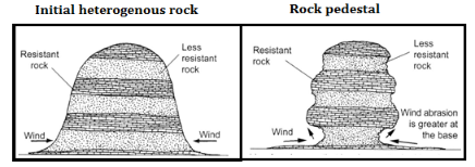
[Diagrams 2 marks]
[Description 5 marks]
- Apart from rock pedestals, name four other features formed due to wind erosion in arid regions. (4 marks)
- Explain four factors that influence the rate of wind transport. (8 marks)
- The strength and the speed of the wind. A strong wind transports heavier and more materials than a weak wind.
- Presence of obstacles such as outcrop rocks and vegetation reduce the wind speed hence reducing its capacity to transport materials.
- Nature of the materials transported. Light particles such as dust are transported to great distances while heavier sand and pebbles over short distances.
- Wind transport is effective during a hot and dry season. Weather changes such as torrential rain washes air borne particles to the ground.
- State three negative influence of desert features. (3 marks)
- Advancing sand dunes can be barriers across transport lines such as roads.
- Spreading sand dunes encroach onto productive land hence desertification.
- Flash floods from torrential rains in deserts deposit materials that block roads.
- Excess surface run off flowing in wadis may sweep away and drown people
- Give three examples of West coast deserts. (3 marks)
-
-
- What is a lake? (2marks)
- A lake is a mass of water which occupies a depression/basin/hollow on the surface of the earth.
- Give three processes that lead to formation of Lakes. (3marks)
- Through earth movements.
- Through vulcanicity.
- Through erosion.
- Through deposition.
- Through mass movement.
- Through weathering by solution.
- Through human activities.
- What is a lake? (2marks)
- Describe how Lake Victoria was formed (6marks)
- Internal land forming processes caused vertical earth movements which resulted in down warping of a huge region.
- Down warping led to the formation of a huge depression/basin.
- Uplifting of landmasses around the depression during the formation of the Mau Ranges and the Ruwenzori altered the drainage of the area.
- Some rivers from Kenya which flowed westwards were cut off and diverted into the depression.
- Some rivers in Uganda such as Katonga, Kafu and Kagera were reversed to flow into the depression.
- Deposition of water into the depression caused further down warping.
- The mass of water which accumulated formed Lake Victoria.
- Explain three factors why some Lakes in the Rift Valley in Kenya are saline. (6marks)
- Some rivers and surface runoff flowing over volcanic rocks empty salt solutions in some lakes thus increasing salinity.
- Some lakes lack surface outlets in form of rivers which lead to accumulation of salts.
- Some lake beds are made of rocks rich in soluble salts where the lake water directly dissolves some salts thus increasing salinity.
- Some lakes are fed by springs rich in salty water which contributes to salinity.
- Some lakes are located in high temperature regions with high evaporation rates thus accumulation of salts.
- Explain four ways in which lakes influence the climate of the surrounding areas. (8marks)
- Large lakes contribute large quantities of moisture which aids in the formation of convectional rainfall.
- Lakes increase the absolute humidity of the surrounding area by adding extra moisture through evaporation.
- Lakes facilitate the development of land and lake breezes through creation of pressure differences between water surface and the land surface.
- Air currents from lakes lower the temperature of the surrounding regions during the hot/summer season.
- During winter, lake breezes may bring a warming effect to adjacent regions e.g. The Great lakes of North America.
- Land and lake breezes may strengthen or reverse the pattern of prevailing winds over adjacent regions.
-
Join our whatsapp group for latest updates
Tap Here to Download for 50/-
Get on WhatsApp for 50/-
Download Geography Paper 1 Questions and Answers - Form 3 Mid Term 3 Exams 2023.
Tap Here to Download for 50/-
Get on WhatsApp for 50/-
Why download?
- ✔ To read offline at any time.
- ✔ To Print at your convenience
- ✔ Share Easily with Friends / Students


