
SECTION A
Answer all the questions in this section.
-
- What is mining?
- State four benefits of soda Ash mining to the economy of Kenya. (4 marks)
-
- Name two methods of deep sea fishing. (2 marks)
- State three ways in which the Government of Kenya is supporting the fishing industry. (3 marks)
-
- Apart from the sun, name three other sources of electricity. (3 marks)
- Give three advantages of using solar energy. (3 marks)
- Give three reasons why it is necessary for the government of Kenya to carry out a national census. (3 marks)
-
- Identify two methods used to control tsetse flies in Kenya. (2 marks)
- State three negative effects of uncollected garbage on the environment. (3 marks)
SECTION B
Answer question 6 and any other two questions in this section.
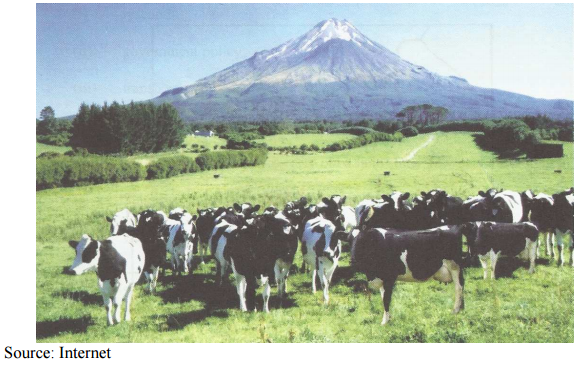
- Study the photograph below and answer question
-
- Identify the type of photograph shown above. (1 mark)
- Draw a rectangle measuring 15 by 10 cm to represent the area covered by the photograph. (1 mark)
- On the rectangle, sketch and label four main features shown on the photograph. (4 marks)
- Using evidence from the photograph, identify two indicators which show that the area receives high rainfall. (2 marks)
-
- Name three exotic types of dairy cattle reared in Kenya. (3 marks)
- Explain three human factors that favour dairy farming in Kenyan Highlands. (6 marks)
- Explain four ways in which dairy farming in Kenya is different from dairy farming in Denmark. (8 marks)
-
-
-
- What is agro-forestry? (2 marks)
- Give four reasons why agro-forestry is encouraged in Kenya. (4 marks)
- Use the map of Kenya below to answer the questions (b) (i) and (ii).
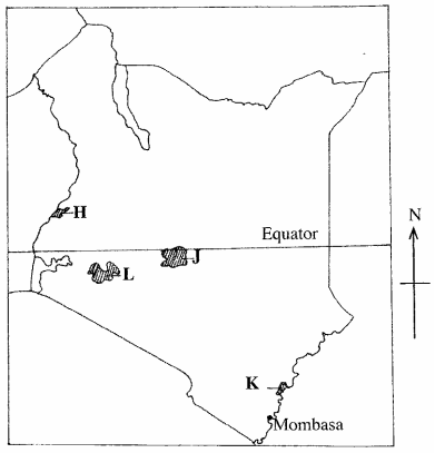
- Name the reserves marked H,J and K. (3 marks)
- Explain four factors that favour the growth of natural forests in the area marked L. (8 marks)
- Explain four problems facing forestry in Kenya. (8 marks)
-
-
-
- Name two provinces in Canada where wheat is grown in large scale. (2 marks)
- State three physical conditions that favour wheat farming in Canada. (3 marks)
- Compare wheat farming in Kenya and Canada under the following subheadings.
- research; (2 marks)
- government policy; (2 marks)
- transport. (2 marks)
- Explain four problems that affect wheat farming in Canada. (8 marks)
- Your Geography class intends to carry out a field study of wheat harvesting in a farm.
- State two reasons for preparing a working schedule. (2 marks)
- Outline two problems that face wheat harvesting you are likely to find out. (2 marks)
- Suppose during the field study you used the interview method to collect data, state two limitations of the method. (2 marks)
-
-
-
- Identify the three types of inland waterways used for transport in Africa. (3 marks)
- Give four reasons why the government of Kenya is expanding pipeline transport. (4 marks)
-
- State three advantages of railway transport. (3 marks)
- State four conditions of roads of Kenya that may lead to motor vehicle accidents. (4 marks)
- The sketch map below shows the Great Lakes and St. Lawrence seaway. Use it to answer question C.
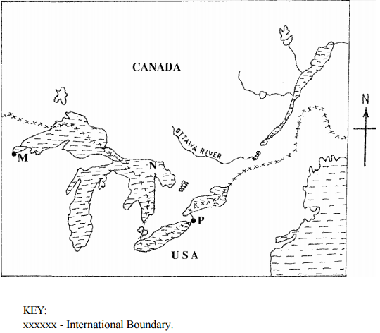
Name:- Ports marked M and P.
- The lake marked N.
- Explain four benefits of the Great Lakes and the St. Lawrence Seaway to the economies of U.S.A and Canada. (8 marks)
-
-
-
- Name two settlement patterns. (2 marks)
- Explain four physical factors that influence settlement. (8 marks)
-
- Explain how the following factors have led to the development of Thika town.
- Location; (2 marks)
- Transport; (2 marks)
- Land. (2 marks)
- Apart from being a transport and communication centre, give three other functions of Thika town. (3 marks)
- Explain how the following factors have led to the development of Thika town.
- Explain three positive effects of urbanization to a country. (6 marks)
-

MARKING SCHEME
SECTION A
-
- what is mining?
- It is the extraction of minerals on or below the earths surface
- four benefits of soda ash mining to the economy of Kenya
- Kenya earns foreign exchange from the exports.
- it provides employment opportunities
- it has led to development of related industries
- it has led to development of Magadi town
- it has led to development of transport and communication network.
- Kenya earns revenue through taxation.
- it has led to the development of social amenities.
Any 4 × 1 = (4 marks)
- what is mining?
-
- Name two methods used in deep sea fishing
- Trawling
- Drifting
- Seining
- Line fishing
Any 2 × 1 = (2 marks)
- State three ways in which the Kenya Government is promoting the fishing industry
- Encouraging fish farming
- Restoking overfished areas
- banning indiscriminate fishing /enforcing the use of standardised nets/ban of fishing to allow breeding.
- Establishing research stations
- controlling water hyacinth
- dredging of silted lakes
- looking for external markets for fish
- Establishment of ministry of fisheries
Any 3 × 1 = (3 marks)
- Name two methods used in deep sea fishing
-
- Apart from the sun name three other sources of electricity
- Water
- Oil
- steam
- Coal
- Wind
- Uranium
- tides/waves
Any 3 × 1 = (3 marks)
- Give three advantages of using solar energy
- it is a cheap source of energy
- it is an inexhaustible source of energy
- it is a clean environmentally friendly form of energy
- it can be stored for future use
- it is easy to use
- it can be found anywhere
Any 3 × 1 = (3 marks)
- Apart from the sun name three other sources of electricity
- state three reasons why it is necessary for the government of Kenya to carry out a nation census
- to plan for basic facilities/to help in distribution of resources
- to determine the total population
- to make decisions on new administrative areas
- to determine the literacy level
- to project the population growth
- to determine the trends of the population
-
- identify two methods used to control tsetseflies in Kenya
- Trapping
- use of chemicals
- clearing bushes
- sterilising males
- Creating Buffer zones.
Any 2 × 1 = (2 marks)
- state three negative effects of uncollected garbage of on the environment.
- Garbage heaps are unattractive
- Garbage produces foul smell
- Garbage washed into water surfaces causes pollution/ cause soil pollution
- Organisms that thrives in garbage may transmit diseases
- Some wastes may cause injuries
- Block drainage system
- Cause obstruction on roads/pavements
Any 3 × 1 = (3 marks)
- identify two methods used to control tsetseflies in Kenya
SECTION B
-
-
- indentify the type of photograph shown above
- Ground general view photograph
- rectangle measuring 15cm by 10 cm
- features shown on the photograph
MAIN FEATURES SHOWN ON THE PHOTOGRAPH
Key- Grassland/paddock/ fences
- Cattle
- Footpath
- Homestead
- Mountain/hill
- Forest
- Hedges
- Sky
- Comelets
- Snow/ice
- using evidence from the photograph ,indentify two indicators that show the area receives high rainfall.
- presence of a forest/trees
- Mountain at the background
- Continuous grass cover/green vegetation
- Diary cattle/cows
Any 2 × 1 = (2 marks)
- indentify the type of photograph shown above
-
- name three exotic types of dairy cattle in Kenya
- Friesian/Holstein
- Jersey
- Guernsey
- Aryshire
- Sahiwal
- Flikvieh/Simmendal
- Swiss brown/ Brown Swiss
Any 3 × 1 = (3 marks)
-
- high population in the area offers ready market for milk and other dairy products
- There are milk processing factories which help in milk processing/ storage
- many parts of Kenya highland is well served by road network which supports fast transport of milk to processing places
- provision of veterinary that helped to promote rearing of high quality breeds.
- Co-operative societies have been set up to market the dairy products
Any 3 × 2 = 6 marks)
- name three exotic types of dairy cattle in Kenya
- ways in which dairy farming in Kenya is different from that of Denmark
- in Kenya , cattle mainly depend on naturally growing grass/whereas in Denmark the cattle is fed on fodder and commercial feeds.
- In Kenya mechanization is limited whereas in Denmark mechanization is idely used
- In Kenya most farmers practice mixed farming while in Denmark dairy farming is highly specialized
- In Kenya most of the dairy products are consumed by the domestic market whereas in Denmark the products are mainly exported.
- In Kenya dairy production is affected by variation in climate whereas in Denmark dairy farming is least affected by variations in climates.
- In Kenya, dairy cooperative movement is in its infancy whereas in Denmark cooperative movement is highly developed.
- In Kenya, artificial insemination/extension services is limited to a few farms whereas in Denmark artificial insemination/extension services are widely used.
- In Kenya, animals graze outdoor throughout the year, whereas in Denmark, animals are kept indoor in winter.
- In Kenya, dairy farming is mainly in the Highlands whereas in Denmark, it is throughout the country.
- In Kenya, research on dairy farming is limited whereas in Denmark, it is extensive.
Any 4 x 2 = (8 marks)
-
-
-
- What is agroforestry?
- It is the deliberate growing of trees and crops/keeping of animals on a piece of land.
(2 marks)
- It is the deliberate growing of trees and crops/keeping of animals on a piece of land.
- Give four reasons why agroforestry is encouraged in Kenya
- To ensure continuous supply of wood fuel/To conserve forests
- Provides raw materials for industries.
- To conserve soil.
- To provide fruits /food for human consumption.
- Trees are a source of income to farmers.
- To provide fodder for animals.
- Trees act as wind breakers/provide shade to young plants.
4x1 = (4 marks)
- What is agroforestry?
- Use the map of Kenya below to answer questions b(i) and (ii). See the question paper
- Name the forest reserves marked H, J and K.
- H - Mt. Elgon
- J - Mt. Kenya
- K - Arabuko Sokoke
3x 1 (3 marks)
- Explain four factors that favour the growth of natural forest in the area marked L.
- The area receives high rainfall/1000 - 1500 mm per year which encourages the growth of trees.
- The area has deep well drained fertile volcanic soils that allow the roots to penetrate deep into the ground. /uptake/provision of nutrients.
- The area has moderate to cool temperatures that allow for the growth of a variety of trees.
- The area is a gazetted forest hence settlement/cultivation is prohibited.
- Some areas are steep which discourages settlement and allow for forest growth.
- Enforcement of laws to allow re-establishment of forests.
Any 4 x 2 = (8 marks)
- Name the forest reserves marked H, J and K.
- Explain four problems facing forestry in Kenya.
- Rapid increase in population has led to encroachment into forest land hence destruction of forests.
- Occurrence of forest fires which have led to the destruction of large areas under forest.
- Illegal logging has led to indiscriminate cutting of trees thereby reducing depleting indigenous tree species.
- Attacks by pest/diseases has led to destruction of valuable tree species.
- Trees are damaged by some wild animals through debarking/trampling uprooting.
- At times, the government allocates land to private developers thus reducing the land under forest.
- Prolonged droughts lead to drying of some trees.
Any 4 x 2 = (8 marks)
-
-
-
- Name two provinces in Canada where wheat is grown on large scales
- Manitoba
- Alberta
- Saskatchewan
Any 2 × 1 = (2 marks)
- physical conditions that favour wheat farming in Canada
- Well drained fertile soils
- Rainfall of about 560mm/moderate rainfall
- Availability of extensive undulating land.
- Sunny summers conditions
Any 3 × 1 = (3 marks)
- Name two provinces in Canada where wheat is grown on large scales
- compare wheat farming in Kenya and in Canada
- Research
- In Kenya, little research is being undertaken on wheat farming while in Canada there is advanced research on wheat farming which produces high yielding seeds/ control of pests and diseases.
(2 marks)
- In Kenya, little research is being undertaken on wheat farming while in Canada there is advanced research on wheat farming which produces high yielding seeds/ control of pests and diseases.
- Government policy
- In Kenya , government policy on subsidies /incentives to wheat farmers while in Canada the government subsidizes the farmers in case of crop failure.
(2 marks)
- In Kenya , government policy on subsidies /incentives to wheat farmers while in Canada the government subsidizes the farmers in case of crop failure.
- Transport
- In Kenya , there is poor road network in wheat growing areas while in Canada there is elaborate railway network in wheat growing areas.
(2 marks)
- In Kenya , there is poor road network in wheat growing areas while in Canada there is elaborate railway network in wheat growing areas.
- Research
- problems that affects wheat farming in Canada
- fluctuation in world prices of wheat has led to farmers being uncertain about their earnings hence turning to growing crops with better earnings.
- the soil has become exhausted due to long use leading to lower yields/lower quality yields
- occurrence of summer heat waves/frost/have destroyed wheat crops leading to lower yields
- Canada faces competition from other wheat producing countries which has reduced the market for their produce
- due to pests and diseases farmers has to spray the crops hence increasing the cost of production.
Any 4 × 2 = (8 marks)
-
- reasons for preparing a working schedule
- it ensures all the intended activities are captured.
- it helps in time management.
- It helps to monitor the field work exercise while it is still in progress
- It enables the research group to remain within the scope of the study.
Any 2 × 1 = (2 marks)
- problems that face wheat harvesting
- shortage of harvesting machinery/combine harvester
- high cost of labour
- Unfavourable weather conditions
- Spillage of wheat grains during harvesting
Any 2 × 1 = (2 marks)
- limitation of methods.
- The respondent may give inaccurate information.
- It is time consuming.
- Some respondent may be unwilling to be interviewed
- Language barrier may rise
Any 2 × 1 = (2 marks)
- reasons for preparing a working schedule
-
-
-
- types of inland water ways used for transport in Africa
- rivers
- lakes
- canals
(3 marks)
- reasons why the government is expanding pipeline transport
- to reduce congestion on/damage of roads by tankers.
- to reduce road accidents by tankers
- to reduce congestion on oil terminus
- pipeline transport is cheaper than road transport
- pipeline transport is more reliable/ convenient than road
- To reduce danage/ loss of the oil products while being transported.
- It is faster means of transport.
Any 4 × 1 = (4 marks)
- types of inland water ways used for transport in Africa
-
- advantages of railway station
- carry heavy bulk goods/large carring capacity
- it is more reliable /effitient due to fixed time schedules/less traffic jams
- it is a cheap mode of transport/ low maintainance cost
- Electric trains are fast.
- Railways are narrow they thus economical in land space
- Trains are less prone to accidents
Any 3 × 1 = (3 marks)
- conditions of roads in Kenya that may lead to accidents
- Some roads have potholes /uneven road surfaces
- Some roads are steep/ have sharp bends
- Some roads are slipperly
- Some roads are unmarked/absence of road signs
- Some roads have loose surface/dusty
- Some roads are narrow.
Any 4 × 1 = (4 marks)
- advantages of railway station
-
- ports marked M and N
- M - Duluth
- N - Buffalo
- Lake marked N
- N - Lake Huron
- ports marked M and N
- benefits of the Great lakes and st. Lawrence seaway to the economies of USA and Canada.
- they have encouraged trade in both countries by providing cheap means of transport
- the dams constructed along the route provide hydroelectric power for domestic /industrial use
- they have led to growth of ports/towns along the route which are focal points for various economic activities.
- they have created employment opportunities in the transport industry thus raising the standard of living of the people in the area.
- they are sources of water for domestic/ industrial use
- they are tourist attractions hence generate income for their attraction
- cheap/easy movement of raw materials
- The countries earn revenue from toll charges levied on the ships that use the routes
Any 4 × 2 = (8 marks)
-
-
-
- settlement patterns
- Nucleated settlement/ clustered
- dispensed settlement /scattered
- linear settlement
- radial settlement
Any 2 × 1 = (2 marks)
- Physical factors that influence distribution of settlements
- Areas that receives (reliable)rainfall attract more people since they can engage in arable farming that receive low rainfall have fewer people as they are unsuitable for arable farming.
- Areas near water bodies attract dense settlements as the water is available nfor domestic / industrial use/ poorly drained areas discourage settlment.
- Areas with cool moderate temperature/moderate temperatures are densely settled as they can support agriculture/ human life/ Areas with extreme temperatures are sparsely settled as they are uncomfortable for human beings
- Areas with fertile soils attract settlement as a wide range of crops can be grown/ poor soils discourage settlement as they are unsuitable for arable farming.
- Forested areas discourage settlements as they may be habitats for dangeous animals/ disease vectors.
- Gentle slopes are densely settled steep slopes are sparsely settled.
- Surfacing slopes are densely settles because they are warmer for human/ crop survival.
Any 4 × 2 = (8 marks)
- settlement patterns
-
-
- location
- its proximity to Nairobi has led to industrial expansion as Nairobi acts as market to its products/supplies/people settle in Thika to be able to work in Nairobi/ industries have been set up in Thika due to congestion in Nairobi industrial area
- Hinterland –Thika town is located in an area with a rich agricultural hinterland which which provides raw materials for industries food for the population hence provides cheap labour.
Any 2 × 1 = (2 marks)
- Transport
- it has a railway/ road connection which provides easy movement of food/people/raw materials/ finished products (2 marks)
- Land
- There is ample/flat land for development of industries/settlement
- The cost of land is relatively cheap hence attracts investors
Any 2 × 1 = (2 marks)
- location
- Other function in Thika
- It is an industrial center
- It is an educational center
- It is a commercial center
- it is a residential centre.
- It is an administrative center
- It is recreational center
- It is a religious/cultural center.
Any3 × 1 = (3 marks)
-
- positive effects of urbanization to a country
- it encourage national unity as people of different nationalities/ ethnic backgrounds interact.
- it promotes links with many areas of transport/ communication networks tend to be focused in urban areas.
- it provides employment opportunities through establishment of commercial/ industrial activities/attracts large population that provides labour.
- It leads to development of infrastructure both within the urban centres and the surrounding rural areas.
- It provides market for agricultural/ industrial goods produced in a country.
Any 3 × 2 = (6 marks)
-
Join our whatsapp group for latest updates
Tap Here to Download for 50/-
Get on WhatsApp for 50/-
Download KCSE 2012 Geography Paper 2 with Marking Scheme.
Tap Here to Download for 50/-
Get on WhatsApp for 50/-
Why download?
- ✔ To read offline at any time.
- ✔ To Print at your convenience
- ✔ Share Easily with Friends / Students


