
SECTION A
Answer all the questions in this section
-
- How does a sea breeze occur? (2 marks)
- Use the map of Africa below to answer question (b) (i). (2 marks)
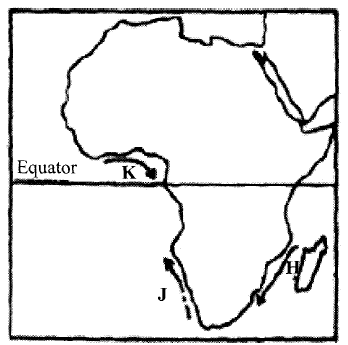
- Name the ocean currents marked H, J, and K.
- State two effects of a warm ocean current on the adjacent coastlands. (2 marks)
-
- Name two types of boundaries according to the plate tectonic theory. (2 marks).
- Give three effects of the movement of tectonic plates. (3 marks)
- The diagram below represents the structure of the atmosphere. Use it to answer question (a)
- Name:
- the parts marked P and Q. (2 marks)
- The layer of discontinuity marked R. (1 mark)
- State two characteristics of the weather conditions in the troposphere. (2 marks)
- Name:
- The diagram below shows some coastal features.

- Name the features marked P, Q and R. (3 marks)
- State two conditions necessary for the formation of a beach. (2 marks)
- Name three major deserts in Africa. (3 marks)
SECTION B
Answer question 6 and any other two questions from this section
- Study the map of Kitale 1:50,000 (sheet 75/3) provided and answer the following questions.
-
- Identify two human made features found at the grid square 2320. (2 marks)
- What is the altitude of the highest point in the area covered by the map?(2 marks)
- Give three types of natural vegetation found in the area covered by the map.(3 marks)
-
- What is the bearing of the air photo principal point at grid square 3426 from the air photo principal point at grid square 2931 ? (2 marks)
- Measure the distance of the dry weather road (C640) from the junction at point M (345142) from the junction at point N (416201) Give your answer in kilometers.(2 marks)
-
- Using a scale of 1 cm to represent 40 metres, draw a cross-section from grid reference 410180 to grid reference 500180. (4 marks)
- On the cross-section mark and name the following:
- a dry weather road; (1 mark)
- River Kaptarit (1 mark)
- a ridge. (1 mark)
- Calculate the (VE) vertical exaggeration of the section. (2 marks)
- Citing evidence from the map, identify five social services offered in Kitale. (5 marks)
-
-
-
- Name two types of submerged highland coasts. (2 marks)
- Identify two resultant features of the emerged highland coasts. (2 marks)
- State three factors influencing deposition by ocean waves.(3 marks).
- With the aid of labelled diagrams describe the formation of the following coastal features:
- Fringing reef (5 marks)
- Spit (5 marks)
- Explain the significance of oceans to human activities. (8 marks)
-
-
-
- What is a lake? (2 marks)
- Name two crater lakes in Kenya. (2 marks)
- Describe how the following lakes are formed. (page 102 q3b)
- Corrie lake (4 marks)
- Oasis (4 marks)
- Lagoon (4 marks
-
- Give three reasons why some lakes in Kenya have saline water. (3 marks)
- Explain how each of the following has affected lakes in Kenya.
- deforestation (2 marks)
- industrialization (2 marks)
- Water needs. (2 marks)
-
- Name three types of faults. (3 marks)
- Apart from compressional forces, explain two other processes that may cause faulting. (4 marks)
- With the aid of diagrams, describe how compressional forces may have led to the formation of the Great Rift Valley. (8 marks)
- Explain five ways in which faulting is of significance to human activities. (10 marks)
-
- Differentiate between magma and lava. (2 marks)
- The diagram below shows some intrusive volcanic features.
Name the features marked E, F and G (3 marks) - Describe how the following features are formed and for each give an example from Kenya:
- A crater (3 marks)
- A geyser (5 marks)
- A lava plateau (4 marks)
- Explain four ways in which volcanic features influence human activities. (8 marks)
MARKING SCHEME
SECTION A
Answer all the questions in this section
-
- How does a sea breeze occur? (2 marks)
- During the day, the land heats faster than the sea
- The air over the land rises
- Cooler air from the sea blows towards the land to replace the rising air
- The cool air from the sea is called the sea breeze
- Use the map of Africa below to answer question (b) (i). (2 marks)
- Name the ocean currents marked H, J, and K.
- H - Mozambique/Agulhas
- J - Benguela
- K - Guinea
- State two effects of a warm ocean current on the adjacent coastlands. (2 marks)
- It warms up the adjacent lan
- It increases the humidity of the adjacent land
- It may lead to rainfall on the adjacent land
- Name the ocean currents marked H, J, and K.
- How does a sea breeze occur? (2 marks)
-
- Name two types of boundaries according to the plate tectonic theory. (2 marks)
- Divergence/extension/constructiv
- Convergence/compressional/destructiveTransform /conservative.
- Give three effects of the movement of tectonic plates. (3 marks)
- They cause earthquakes.
- It can lead to formation of Fold Mountains.
- It can lead to formation of New oceanic crust.
- It may lead to formation of Submarine islands/volcanic islands.
- Name two types of boundaries according to the plate tectonic theory. (2 marks)
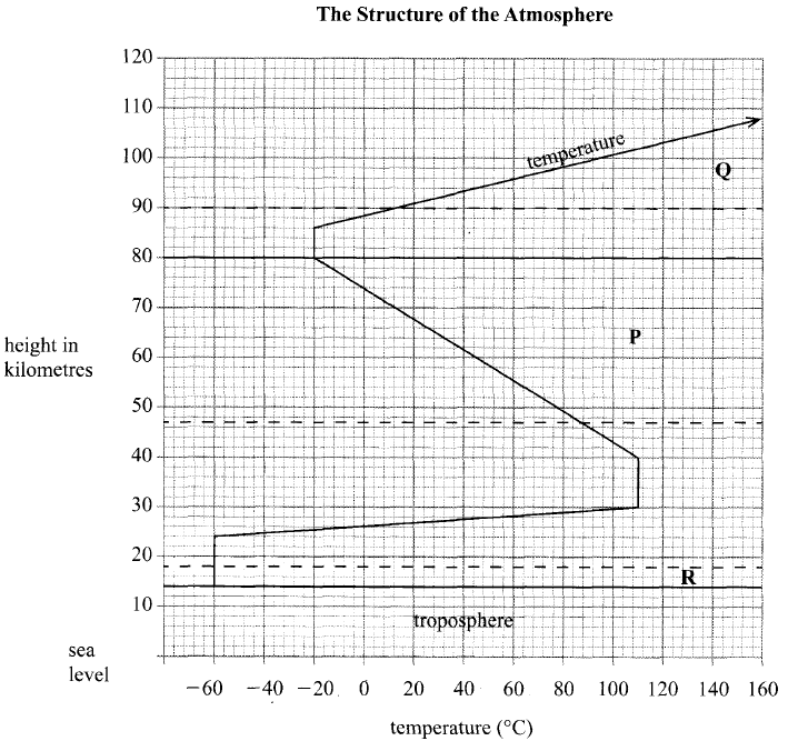
- The diagram below represents the structure of the atmosphere. Use it to answer question (a)
- Name:
- the parts marked P and Q. (2 marks)
- P – Mesosphere
- Q- Thermosphere/ Ionosphere
- The layer of discontinuity marked R. (1 mark)
- R – Tropopause
- the parts marked P and Q. (2 marks)
- State two characteristics of the weather conditions in the troposphere. (2 marks)
- Temperatures decrease with an increase in height/normal lapse rate / the rate of decrease is 1 °C for 160 metres of height/0.65°C per 100 m/6.5 per 1000m
- Pressure falls with an increase in height.
- The speed of wind increases with an increase in height.
- It contains most of the atmospheric water vapour/clouds.
- Name:
- The diagram below shows some coastal features.
- Name the features marked P, Q and R. (3 marks)
- P - Headland
- Q - Spi
- R – Stack
- State two conditions necessary for the formation of a beach. (2 marks)
- Presence of abundant supply of materials to be deposited.
- Presence of a shallow shore or continental shelf
- A relatively weak longshore current.
- A weak backwash or strong swash or constructive waves
- Gently sloping land at the sea shore.
- Name the features marked P, Q and R. (3 marks)
- Name three major deserts in Africa. (3 marks)
- Sahara
- Kalahari
- Namib
SECTION B
Answer question 6 and any other two questions from this section
- Study the map of Kitale 1:50,000 (sheet 75/3) provided and answer the following questions.
-
- Identify two human made features found at the grid square 2320. (2 marks)
- What is the altitude of the highest point in the area covered by the map?(2 marks)
- 2362 metres
- Give three types of natural vegetation found in the area covered by the map.(3 marks)
-
- What is the bearing of the air photo principal point at grid square 3426 from the air photo principal point at grid square 2931 ? (2 marks)
- Measure the distance of the dry weather road (C640) from the junction at point M (345142) from the junction at point N (416201) Give your answer in kilometers.(2 marks)
- 12.1km ± 0.1km
-
- Using a scale of 1 cm to represent 40 metres, draw a cross-section from grid reference 410180 to grid reference 500180. (4 marks)
- On the cross-section mark and name the following:
- a dry weather road; (1 mark)
- River Kaptarit (1 mark)
- a ridge. (1 mark)
- Calculate the (VE) vertical exaggeration of the section. (2 marks)
- Citing evidence from the map, identify five social services offered in Kitale. (5 marks)
- Health/medical services
- Recreational services
- Religious services
- Security services
-
-
-
- Name two types of submerged highland coasts. (2 marks)
- Longitudinal / Dalmatian
- Ria
- Fiord / / Fjord
- Identify two resultant features of the emerged highland coasts. (2 marks)
- Raised geos / blow holes
- Raised cliffs
- Raised wave cut-platforms
- Raised beaches
- Raised caves
- Raised notches
- Raised archs / stumps / stack
- Name two types of submerged highland coasts. (2 marks)
- State three factors influencing deposition by ocean waves.(3 marks)
- The existence of gentle sloping shore.
- Presence of shallow water along the coastline.
- The occurrence of a strong swash and weak backwash / constructive waves.
- The existence of indented coastline.
- Ample longshore drift materials to be deposited.
- With the aid of labelled diagrams describe the formation of the following coastal features:
- Fringing reef (5 marks)
- It is formed when coral polyps start building a reef near the shore extending seawards.
- The rate of accumulation is faster seawards than towards the shore.The reef therefore becomes steeper seaward than towards the shore, enclosing a narrow and shallow lagoon.
- The accumulated coral materials form a fringing reef.

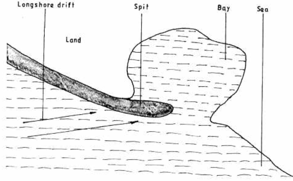
- Spit (5 marks)
- It forms on a shallow shore at a point where the coastline bends landward
- Deposition occurs as the longshore drift is halted.
- More materials / deposits are piled up forming an elongated low lying ridge growing towards the sea.
- The elongated low lying ridge with one end attached to the coast and the other projecting into the sea is the spit.
- Fringing reef (5 marks)
- Explain the significance of oceans to human activities. (8 marks)
- Oceans provides building materials.
- Oceans modify the climate of the adjacent lands thus enhancing agricultural activities.
- Oceans are used by water vessels thereby enhancing transport/communication.
- Oceans provide sites for recreational activities thus promoting tourism.
- Oceans are habitats for aquatic life hence providing food/ income to humans.
- Oceans habour minerals which are extracted for economic development.
- Ocean waves/ tides are harnessed which generate electric power for industrial/ domestic use.
- Oceans provide water for cooling industrial plants.
- Oceans encourage education and research.
- Ocean provides ideal grounds for testing military weapons.
-
-
-
- What is a lake? (2 marks)
- A lake is an accumulation of water in a wide hollow or depression/it is an extensive hollow in the earth’s surface which contains water
- Name two crater lakes in Kenya. (2 marks)
- Challa
- Paradise
- Simbi
- Sonanchi
- What is a lake? (2 marks)
- Describe how the following lakes are formed. (page 102 q3b)
- Corrie lake (4 marks)
- Snow accumulates in a depression on the mountain side
- Snow gets compacted into ice forming a cirque glaciers
- Frost action /alternate freeze –thaw action enlarges the hollow
- Plucking process steepens the back wall
- Eventually a deep arm – chair shaped depression is formed
- When the corrie fills up with melt water it forms a corrie lake
- Oasis (4 marks)
- A pre existing depression formed through faulting or otherwise is exposed to wind erosion
- Wind eddies remove unconsolidated materials through deflation
- Futher deflation leads to depression reaching the water table
- Water oozes out of the ground and collects into the depression to form a lake known as an oasis
- Lagoon (4 marks)
- Sand / silt are deposited along indented / irregular coast
- The deposits accumulate forming a spit
- The continued deposition elongates the spit eventually blocking the mouth of the bay forming a bay bar
- The bay bar separates part of the sea water from the open sea
- The enclosed sea water is the lagoon
- Corrie lake (4 marks)
-
- Give three reasons why some lakes in Kenya have saline water. (3 marks)
- They lack outlets to the sea
- Some have salt bearing rocks on the lake bed
- High temperature in the surrounding area leads to high evaporation
- Heavy deposition of mineral salts into the lakes by the surface runs off
- Underground seepage of water that is rich in mineral salts
- Explain how each of the following has affected lakes in Kenya.
- deforestation (2 marks)
- It exposes soil which is eroded and carried into the lake causing siltation
- It destroys catchment areas which reduces water fed into the lakes
- industrialization (2 marks)
- Establishment of industries has led to disposal of waste/pollution/contamination of lakes
- Establishment of industries has led to increased water use which has lowered water levels
- Water needs. (2 marks)
- When water is diverted to farms for irrigation, water levels in the lakes are lowered
- deforestation (2 marks)
- Give three reasons why some lakes in Kenya have saline water. (3 marks)
-
-
- Name three types of faults. (3 marks)
- Normal fault,
- Reverse fault,
- Tear or shear or slip or transform or wrench or strike slip fault,
- Thrust fault,
- Anticlinal fault
- Apart from compressional forces, explain two other processes that may cause faulting. (4 marks)
- Faulting may be caused by force acting horizontally away from each other which causes tension in the crystal rocks. Due to tensional forces the rocks stretch and fracture causing faults.
- Faulting may occur where horizontal forces act parallel to each other in the opposite or same direction resulting in shearing.
- Faulting may also occur due to vertical movements which may exert a strain in the rocks making them to fracture
- Name three types of faults. (3 marks)
- With the aid of diagrams, describe how compressional forces may have led to the formation of the Great Rift Valley. (8 marks)
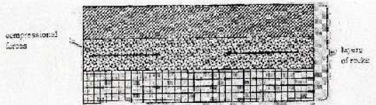
- Two parallel lines of weakness develop and these reverse faults.
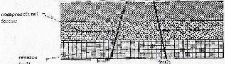
Compression forces may push the other blocks towards each other.The outer blocks ride over the middle block and the middle block sinks or subsides or may remain stable.The sunken middle part forms a depression called a rift valley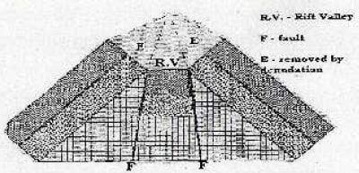
- Two parallel lines of weakness develop and these reverse faults.
- Explain five ways in which faulting is of significance to human activities. (10 marks)
- Faulting leads to formation of features that form beautiful scenery which attract tourists.
- Faulting leads to formation of lakes that are important fishing grounds or tourists' sites or mining sites.
- The lakes provide water for irrigation or for domestic or industrial use.
- Faulting causes displacement of rocks which exposes minerals that are mined.
- Faulting may lead to the formation of mountains or horsts which experience rainfall on the windward side that give rise to rivers which provide water for industrial or domestic or agricultural or industrial use for production of hydroelectric power.
- Block mountains formed through faulting lead to formation of relief rainfall on the windward side which favours agriculture, settlements and forestry.
- Subsidence of land as a result of faulting may lead to loss of life and property.
- Springs occurring of the foot of fault scarps attract settlements.
- Faulting creates deep faults which are passages of stream jets which may be utilized for geothermal power production. Rivers flowing over fault scarps may form waterfalls which can be harnessed to produce Hydro Electric Power for industries.
- When faulting occurs across a ridge it may provide a dip which could form a mountain pass where transport and communication lines can be constructed or may hinder development of transport.
-
- Differentiate between magma and lava. (2 marks)
- Magma is the molten rock material which originates from the interior of earth, cools while below the earth’s surface (and has large crystals) while lava is the molten rock materials that has reached the surface. (Has solidified and has small crystals.
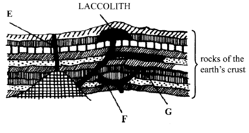
- The diagram below shows some intrusive volcanic features.
Name the features marked E, F and G (3 marks)- E - Dyke
- F - Lapolith
- G – Sill
- Describe how the following features are formed and for each give an example from Kenya:
- A crater (3 marks)
- Eruption of lava through a central vent causes building up of a cone. The lava in the vent cools and contracts. The cool lava withdraws into the vent leaving a shallow depression of the cone. Gas explosions may blow away surface rocks causing a crater. Examples include Mt Longonot, Mt Menengai, Mt Suswa or Mt Marsabit
- A geyser (5 marks)
- Rainwater percolates down through cracks in the rocks. The water gets into contact with hot igneous rocks. The water is super heated and gases/steam form. Pressure builds up in the cracks. The pressure causes steam and water to be ejected explosively as jet to the surface intermittently. The water and steam are emitted intermittently as pressure level changes. Example –Lake Bogoria
- A lava plateau (4 marks)
- It is formed when magma reaches the surface of the earth through a series of vents/fissures. The lava is extremely fluid/ultra-basic. The lava spreads evenly over a large area .The lava cools slowly and solidifies. Examples - Yatta plateau, Uasin Gishu plateau and Laikipia plateau
- A crater (3 marks)
- Explain four ways in which volcanic features influence human activities. (8 marks)
- Volcanic highlands or mountains are sources of rivers which provide water for domestic or agricultural or industrial use.
- Volcanic rocks weather down to form fertile volcanic soils which support agriculture.
- Volcanic rocks are important building materials in the construction industry.
- Volcanic features are tourist attractions which promote tourism.
- Volcanic mountains or highlands influence formation of relief rainfall which encourage agricultural activities.
- Volcanic highlands influence formation of relief rainfall which encourage agricultural activities.
- Volcanic highlands or mountains modify temperatures making them attractive to human settlements.
- Volcanic features such as steam jets and geysers provide suitable sites for geothermal power generation.
- Differentiate between magma and lava. (2 marks)
Join our whatsapp group for latest updates
Tap Here to Download for 50/-
Get on WhatsApp for 50/-
Download KCSE 2016 Geography Paper 1 Questions with Marking Scheme.
Tap Here to Download for 50/-
Get on WhatsApp for 50/-
Why download?
- ✔ To read offline at any time.
- ✔ To Print at your convenience
- ✔ Share Easily with Friends / Students


