-
- What is natural vegetation 2 marks
- It refers to the plant cover growing wildly of the earth’s surface without interference by man 2 marks
- State three characteristics of the Mediterranean type of vegetation 2 marks
- Some plants have small/thick skinned/leatherly spiny leaves
- Some plants have long nuts
- Some plants have thick barks
- Some plants have large fleshly bulbous roots
- Some plants have shiny/waxy leaves
- Some plants are evergreen
- Some plants have fleshy leaves
- Scrubs/thickets/thicky bushes are common Any 3*1=3 marks
- What is natural vegetation 2 marks
-
- What is solar system 2 marks
- Solar system refers to the composition of the sun,planets and other heavenly bodies related to the sun
-
- Solar eclipse 1 mark
- Features marked
L-Moon 1 mark
M-Shadow 1 mark
- What is solar system 2 marks
-
- What is an isobar?
- It is a line connecting places with the same atmospheric pressure
- What is the effect of the International Date Line on time?
- On crossing this longitude while going to the west a day is lost while a day is gained while crossing to the east 2*1=2 marks
- What is an isobar?
-
- Name the features marked
P-Horst/Block mountain
Q- Rift valley
R-Scarp/Ecarpment 3 marks - Differentiate between a normal and reverse fault 2 marks
- A normal fault is caused by tension inclined plane with inclination of the fault plane while reversed fault result from compression forces where one block is pushed upwards in relation to the other 2 marks
- Name the features marked
-
- Describe carbonation as a process of chemical weathering
- Rain water mixes with carbon(iv) oxide to form weak carbonic acid
- The acid rain falls on joints in limestonr rocks
- Chemical reaction results in formation of calcium bicarbonate
- The Calcium Carbonate formed is easily by a solution a process called carbonation
- Give two reasons why there are few settlements in a Karst landscape
- Rock has thin soils which discourage agriculture
- Presence of inadequate surface water for domestic use
- The surface is rugged and unstable for building houses Any 2*1=2 marks
SECTION B
- Describe carbonation as a process of chemical weathering
-
-
- What type of map is Kitale
- Topographical map 1 mk
- Convert the scale used to draw the map of Kitale into a statement scale
- 50,000 × 1km=0.5 km
100,000
1 cm to 0.5 km 2 marks
- 50,000 × 1km=0.5 km
- Height in metres of the trigonometric station in the grid square 2311
- 1919 m (1901-1919m) 2 marks
- What is the latitude extent of the map? 2 marks
- 1°00’N-1°12’N 2 marks
- Measure the length in Kilometres of R.Koitobos from Mc.Call’s bridgeto the grid point 304110 2 marks
- 14.4 km+-0.1 (14.3-14.5 Km) 1*2=2 marks
- What is the bearing of the trigonometric station at grid square 2823 from the Air photo principal point at grid square 2918 2 marks
- 345°(+-1°) (344°-346°) 1 2=2 marks
- What type of map is Kitale
- Draw a rectangle enclosed by Easting 23 and 31 and Northing 11 and 16
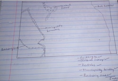
- Describe the drainage of the area covered by the map of Kitale 5 marks
- There are many permanent rivers
- The main river is R.Koitobos
- Some of the rivers are disappearing
- Most of the rivers are flowing from N.E generally towards the South
- Most of the rivers have formed dendritic drainage pattern
- Most of the rivers in the N.E are in their youthful stage
- There is presence of seasonal swamp to the western side of the map
- There is presence of papyrus swamp along River Koitobos
- Citing evidence from the map,state two functions of Kitale town 4 marks
- Transport function evidenced by presence of road/railway
- Health/medical function evidenced by presence of hospital
- Security function evidenced by presence of police station
- Religious function evidenced by presence of church
- Recreation evidenced by golf course/sports club
- Residential function evidence by built up areas/settlement
-
-
-
- Total annual rainfall for the station 2 marks
10+15+12+45+50+41+30+19+16+13+12+11=274 mm - The diurnal range of temperature 2 marks
23°c-13°c=10°c
- Total annual rainfall for the station 2 marks
-
- A simple bar graph drawn for station W
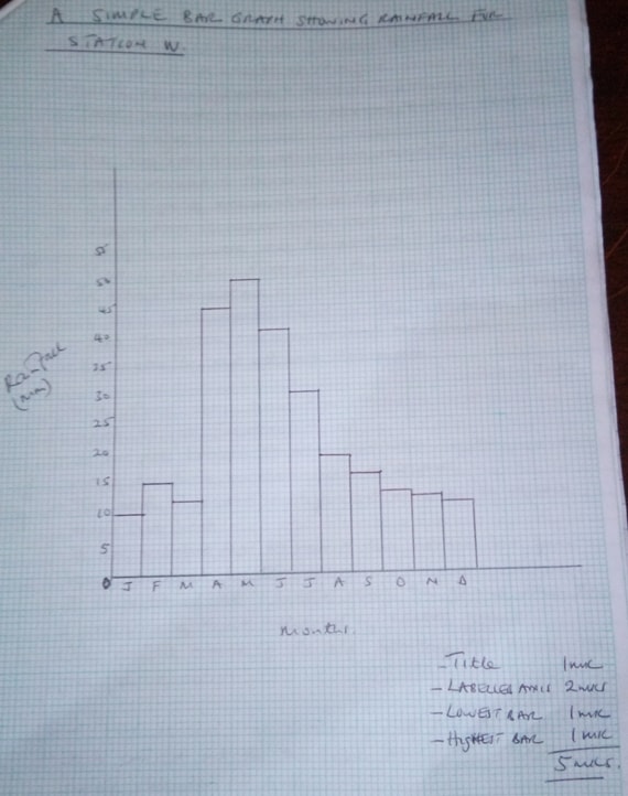
- Describe the climate of station W 5 marks
- The highest amount of rainfall falls in the month of May/lowest is reached in January
- Total annual rainfall is 274 mm/station receives low rainfall
- The highest temperature was recorded in May/lowest recorded in January
- The range of temperature is high/14°c
- Temperature is highest when rainfall is highest/rainfall is lowest when temperature is lowest
- There is rainfall throughout the year/have no dry month
- The average temperature is 16.6°c Any 5*1=5 marks
- List two instruments found in the Stevenson’s Screen 2 marks
- Six’s thermometer/maximum/minimum thermometer
- Hygrometer/Dry and wet bulb thermometer 2*1=2 marks
- State four ways how the Stevenson Screen is adapted to its functions 4 marks
- It has got louvers to allow circulation of air in and out of the screen for the thermometer to be accurate
- It has metallic legs to prevent the wooden box from being destroyed by termites
- It is positioned at1.2 metres above the ground where there is free flow of air,not influenced by heated ground
- The roof is made of double boarding to allow free flow of air 4*1=4 marks
- Give five reasons for carrying out weather forecasting 5 marks
- It is carried out for the farmer to organise their farming calendars effectively
- Helps travellers to know the type of dressing to have in a day
- Assist in the aviation industry to establish when a plane is to land/take off
- Helps the military personnel to plan when to conduct military activities
- Helps to cope with natural calamities related to weather by taking precautionary measures 5*1=5 marks
- A simple bar graph drawn for station W
-
-
-
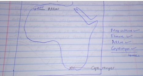
- 0utline map of Africa
- Name for types of folds
- Simple/Symmetric fold/isoclinal
- Asymmetric fold
- Over fold
- Recumbent fold
- Overthrust/fold thrust/Nappe
- Anticlinorium synclinorium complex Any 4*1=4 marks
- 0utline map of Africa
-
- Name the parts marked
- X-limb 1 mark
- Y-Syncline 1 mark
- Name the force marked Z
- Compressional force 1 mark
- Name the parts marked
- While using a well labelled diagram, describe the formation of Fold Mountain 8 marks
- An extensive shallow depression/geosyncline develops on the earth
- Prolonged erosion in adjacent land causes accumulation of sediment in the geosynclines, in great thickness
- The weight of the sediment causes the geosyncline to subside
- More sediments accumulates in the geosyncline to subside
- More sediments accumulates in the geosyncline
- Accumulates sediments further subsides triggers compressional forces from either side of the geosyncline
- The layers of sediments in the geosyncline are folded and arch upwards at the edges of the geosyncline
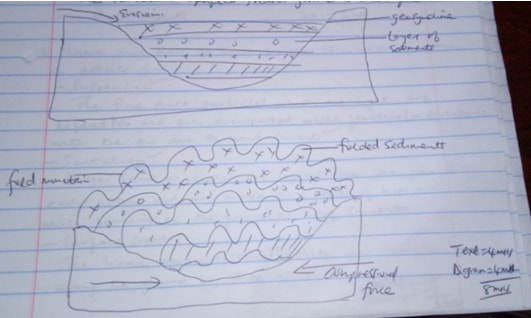
- The resultant uplifted folded grounded is called fold mountain
- Explain three positive ways in which fold mountains influences human activities
- Fold mountains are water catchment areas which help feed rivers providing water for domestic/industrial/irrigation use
- Fold mountains are often forested and provide valuable timber used in construction and building industry
- Fold mountains are beautiful hence attract tourist hence a country earns foreign exchange
- Some fold mountains have valuable mineral deposits like coal which is brought closer to the surface for easier exploitation
- Fold mountains influences transport system ad passes Any3*2=6 marks
-
-
-
- Name two types of deserts 2 marks
- Cold deserts
- Hot deserts 2*1=2 marks
- Name and describe three process of wind transportation in deserts 6 marks
- Suspension
The fine dust particles which are light are lifted and are transported while floating/in turbulence with the air due to wind currents - Saltation
Large sand particles are lifted from the ground by eddy action and are moved in a series of hops and jumps/while bouncing on the ground by wind currents - Surface creep
The heavy particles/stones/pebbles are rolled/dragged along the ground by force of wind
- Suspension
- Name two types of deserts 2 marks
- While using a well labelled diagram,describe how the following features are formed
- Zeugen
- The desert has alternating horizontal layers of hard and soft rocks
- The top layer of hard rock has cracks
- Weathering process open up the joints/cracks
- Wind abrasion erodes the joints/cracks deepening them to reach the soft layer of rocks
- As abrasion continues, farrows are formed and gradually widened
- The hard/resistant rock form ridges separating the fallows called zeugens
- The process creates a ridge and farrow land scape

- Rock pedestal
- A rock outcrop made of alternating hard and soft layers
- Wind abrasion attacks the rock outcrop
- The soft layers are eroded faster than the hard layers
- Wind abrasion is greatest near the ground level
- This results into a rugged sloped rock feature called rock pedestal
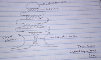
- Zeugen
- Your school carried out a field study on desert vegetation
- State three ways how you noted the vegetation have adapted themselves to the hot desert climate
- Some vegetation had small/thin leaves to reduce transpiration
- Some vegetation had waxy/shiny leaves
- Some vegetation had thick/rough bark
- Some vegetation had fleshy stems
- Some trees were umbrella shaped 2 marks
-
- Advocating planting of more trees
- Carrying out irrigation
- Construction of gabions to reduce erosion Any other relevant 2*1=2 marks
- State three ways how you noted the vegetation have adapted themselves to the hot desert climate
-
-
-
- What is an ice sheet? 2 marks
- An ice sheet is a large continuous mass of ice which covers vast/extensive areas of lowland 1*2=2 marks
- Give two reasons why there are no ice sheets in Kenya 2 marks
- Kenya is located within the tropics where the temperatures are high discouraging formation of ice sheet
- Kenya is located in the low latitude areas where formation of ice is limited 2*1=2 marks
- What is an ice sheet? 2 marks
- Describe how a pyramidal peak is formed
- Ice accumulates in the pre-existing depressions/hollows on the mountain top
- Ice exerts pressure on the hollows
- Plucking action of ice enlarges the hollows allowing more ice to accumulate
- Freeze-thaw action leads to expansion of hollows making them large basins
- Mivation eats into the back wall of the basins making them recede into the mountain side
- A steep knife edge ridge are formed separating the basins
- Three or more of these ridges meet at the mountain top forming a rough pean called pyramidal peak 5*1= 5 marks
-
- Name the type of moraine marked
- S-Medial moraine 1 mark
- T-Lateral moraine 1 mark
- V-Terminal moraine 1 mark
- Explain four effects of glaciated features in upland areas 8 marks
- Glacial upland areas form magnificent/beautiful features like pyramidal peak which attract tourists/encourage ice skiing and ice skating
- Glaciated mountains encourage the growth of forests which encourage lumbering supporting the building industry
- Waterfalls formed in glaciated uplands provide suitable sites for hydroelectric power production for domestic/industrial use
- Flooded coastline form deep well sheltered harbour/suitable fishing grounds
- U-shaped valleys in upland areas form natural route ways for the society to us e
- The upland glaciated landscape valleys are utilised for livestock farming Any 4*2=8 marks
- Name the type of moraine marked
-
- Give reasons why it would be difficult to undertake the field study on glaciated features on the mountain
- Climbing the mountain to access the features would be difficult due to rugged terrai
- Time needed to do so would be inadequate
- Harsh weather condition/sudden rain/extreme low temperatures may hinder their work
- The thick vegetation in the lower slopes may hinder movement
- Attack by wild animals may make it difficult to access the area
- It would be difficult to conduct a previsit Any other relevant 4*1=4 marks
- How the students would us e a photograph of Mt.Kenya to identify the glaciated features on the mountain
- By dividing it into parts
- By observing and identifying the features in each part of the photograph
- By recording the features observed
- By labelling the features observed 3*1=3 marks
- Give reasons why it would be difficult to undertake the field study on glaciated features on the mountain
-
Join our whatsapp group for latest updates
Tap Here to Download for 50/-
Get on WhatsApp for 50/-
Download GEOGRAPHY PAPER 1 Marking Scheme - 2017 MURANG'A MOCK EXAMINATION.
Tap Here to Download for 50/-
Get on WhatsApp for 50/-
Why download?
- ✔ To read offline at any time.
- ✔ To Print at your convenience
- ✔ Share Easily with Friends / Students

