
Instructions to Candidates
- Answer all questions in section A.
- In section B, Answer question 6 and any other two questions from the remaining questions.
- Answer all questions using the answer booklet provided.
- Candidate should check that all pages are printed and no questions are missing.
SECTION A
Answer all the questions in this section.
-
- Differentiate a Star from a Natural satellite. (2mks)
- State three weaknesses of the Passing Star Theory. (3mks)
-
- Give three ways in which igneous rocks can be classified. (3mks)
- Describe how Dynamic metamorphism leads to formation of metamorphic rocks. (2mks)
-
- Outline three agents of Weathering. (3mks)
- State how topography influences Weathering of rocks. (3mks)
-
- State the factors that influence river deposition. (3mks)
- Describe radial drainage pattern. (2mks)
-
- What is Glaciation? (2mks)
- State three factors that influence glacial erosion. (3mks)
SECTION B
Answer Question 6 and Any Other two Questions in this Section.
- Study the map of Yimbo (Sheet 115/1 provided and use it to answer the questions the following questions.
-
- identify the latitudinal extent of the area covered by the map. (1 mark)
- Give the six-figure grid reference of Ramogi hill. (1 mark)
-
- Convert the ratio scale of the map into statement scale. (2 marks)
- Calculate the area covered by Lake Victoria to the east of Easting 30 in square. kilometres (2 marks)
-
- Draw a cross-section along the Northing 90 and between the Eastings 30 and 36, using a vertical scale of 1 cm represent 50 m. (4 marks)
On the cross-section, mark and name:- Thicket vegetation (1 mark)
- Kapiyo school (1 mark)
- River (1 mark)
- Calculate the vertical exaggeration of the drawn cross-section. (2 marks)
- Draw a cross-section along the Northing 90 and between the Eastings 30 and 36, using a vertical scale of 1 cm represent 50 m. (4 marks)
-
- Citing evidence, identify two economic activities carried out in the Yimbo area. (2 marks)
- Describe how relief has influenced the distribution of settlements in the area covered by the map. (4 mark)
- Describe the drainage of river Yala (4marks)
-
-
- Distinguish between orogenic and epierogenic earth movements. (2marks)
- Give any three features associated with the extension boundary. (3marks)
- Describe how the following theories causes earth’s movements
- Convectional currents (4marks)
- Gravitative pressure (4marks)
- State four characteristics of the Great Gregory Rift Valley. (4marks)
- Explain four effects of faulting on physical environment. (8marks)
-
- Differentiate between derived and cultivated vegetation. (2 marks)
- Explain how the following factors influence vegetation distribution in Kenya:
- Living organisms (2 marks)
- Precipitation (2 marks)
- The map below shows the global distribution of vegetation. Study and use it to answer the questions that follow.
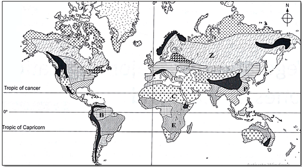
- Identify the vegetation labelled B, C and Z. (3 marks)
- Describe the adaptive characteristics of the vegetation labeled E on the map. (6 marks)
- Your class is to planning to undertake a field study on vegetation in Mau forest;
- State three preparations you would carry out. (3 marks)
- Give three sampling techniques you would use. (3 marks)
- Identify four challenges you are likely to face during the actual field study. (4 marks)
-
-
- Differentiate between Aridity and Desertification. (2marks)
- Explain the following processes of wind erosion.
- Abrasion (2mks)
- Deflation. (2mks)
- With a well labelled diagram, describe the formation of a Mushroom block. (5mks)
-
- State three factors which influence wind transport. (3mks)
- Give three characteristics of a Barchan. (3mks)
- Marsabit Boys high school went for a field study near their school on action of water in arid areas.
- Give three reasons why they required a route map. (3mks)
- State three problems they are likely to encounter while in the field. (3mks)
- Name two features they are likely to observe. (2mks)
-
-
- State three factors necessary for the development of Karst scenery. (3mks)
- The diagram below shows an Artesian Basin. Use it to answer the question (i) and (ii).
- Name the parts marked S and T. (2mks)
- State three ideal conditions for the formation of an artesian well. (3mks)
- Explain how a Doline is formed. (4mks)
-
- Give reasons why some lakes are fresh. (3mks)
- Describe how a tarn is formed. (5mks)
- Explain two negative effects of lakes. (4mks)

MARKING SCHEME
SECTION A
Answer all the questions in this section.
-
- Differentiate between a Star and a Natural satellite. (2 marks)
- A star is a heavenly body possessing its own light which it transmits while a natural satellite is a celestial body that orbits a larger celestial body/ a planet.
- State three weaknesses of the Passing Star Theory. (3 marks)
- Chances of another star approaching the sun is minimal
- The high temperature materials drawn from the sun /star would disperse rather than condense.
- Does not explain where the sun and the star came from.
- Differentiate between a Star and a Natural satellite. (2 marks)
-
- Give three ways in which igneous rocks are classified (3 marks)
- Mineral/chemical composition
- depth
- Mode of formation
(Any 3x1=3mks)
- Describe how Dynamic metamorphism leads to formation of metamorphic rocks. (2 marks)
- The weight of the overlying rocks exerts a lot of pressure on the lower layers.
- This leads to change in the grain/rock structure, so the physical appearance and the character of the rocks change.
- Give three ways in which igneous rocks are classified (3 marks)
-
- Give three agents of Weathering. (3 marks)
- Heat
- Water
- Air
- Dissolved substances/acids
- Plants and animals.
(Any 3x1=3mks)
* Do not award temperature in place of heat*
- State how topography influences Weathering of rocks. (2 marks)
- Weathering is faster on steep slopes because the rocks are exposed since the weathered materials are removed faster by gravity.
- On gentle slopes and flat areas the rate of weathering is slow because weathered materials cover rocks beneath.
(2x1=2mks)
- Give three agents of Weathering. (3 marks)
-
- State the characteristics of Bird’s foot delta. (3 marks)
- Forms a shape like the foot of a bird.
- Made up of fine alluvium.
- Has a finger-like projection into the sea.
- Has few distributaries (3-4).
- Forms where the waves and currents are very weak.
(Any 3x1=3mks)
- Describe radial drainage pattern. (2 marks)
- Formed where rivers flow from one central point e.g a mountain /highland
- The rivers flow in all directions from the central point.
- Is influenced by the rock structure and the slope.
- State the characteristics of Bird’s foot delta. (3 marks)
-
- What is Glaciation? (2 marks)
- This is the process by which moving ice erodes transports and deposits materials on the earth’s surface.
- State three factors that influence glacial erosion. (3 marks)
- Nature of the underlying rock
- The speed of the moving ice
- Availability and amount of debris in the moving ice.
- Thickness and weight of the ice.
- Seasonal temperatures changes lead to more erosion during summer when the ice melts.
(Any 3x1=3mks)
- What is Glaciation? (2 marks)
SECTION B
Answer question 6 and any other TWO questions from this section.
- Study the map of Yimbo 1: 50 000 (Sheet 115/1) provided and use it to answer the questions that follow.
-
- Identify the latitudinal extent of the area covered by the map. (1 mark)
- Between latitudes 00 00’ and 00 15’ S
- Give the six-figure grid reference of Ramogi hill. (1 mark)
- 198996
- Identify the latitudinal extent of the area covered by the map. (1 mark)
-
- Convert the ratio scale of the map into statement scale.(2 marks)
- 1:50000
- 1cm rep 50000cm/ 100000cm
- 1 cm rep 0.5 km
- Calculate the area covered by Lake Victoria to the east of Easting 30 in kilometer square. (2 marks)
- Full squares = 14
- Half squares = 34/2
- Total area = 31 km2
- Convert the ratio scale of the map into statement scale.(2 marks)
-
- Draw a cross-section along the Northing 90 and between the Eastings 31 and 37 using a vertical scale of 1 cm represent 20 meters. (4 marks)
On the cross-section, mark and name:- Thicket vegetation. (1 mark)
- A footpath. (1 mark)
- River. (1 mark)
- Calculate the vertical exaggeration of the drawn cross-section. (2 marks)
VE= vertical scale/horizontal scale
1/2000/ 1/50000
1/2000 X 50000/1
= X25.
- Draw a cross-section along the Northing 90 and between the Eastings 31 and 37 using a vertical scale of 1 cm represent 20 meters. (4 marks)
-
- Citing evidence, identify two economic activities carried out in the Yimbo area. (2 marks)
- Transport - Loose surface road at grid reference 3890.
- Trade - A market at grid reference 3284.
- Describe how relief has influenced the distribution of settlements in the area covered by the map. (4 marks)
- There is no settlement in depressions due to water logging which makes it difficult to erect houses. Eg. At grid reference 2687.
- There are no settlements in areas with steep slopes since it is difficult to erect houses. Eg on slopes of Ramogi hill
- There are little or no settlements in river valleys since they are prone to flooding which would destroy the settlements. Eg along river Alara Yenga valley.
- There are dense settlements in gentle sloping areas since it is easy to erect settlements. Eg. At GR 3280.
- There is little or no settlements in flat lowland areas due to fear of flooding which would destroy the settlements. Eg at grid reference 3776
(any 2x2=4marks)
- Describe the characteristics of the long profile of river Yala. (4 marks)
- It is a permanent river.
- There is a papyrus swamp along the river.
- The river has man tributaries to the east of easting 36.
- Some tributaries join river Yala at an acute angle forming a dendritic drainage pattern.
- The river flows from south east to north-west direction.
- To the west of easing 36, River Yala is in its old stage as suggested by presence of pronounced meanders.
- To the east of easting 36, river Yala is in its mature stage as suggested by presence of gentle meanders and presence of tributaries.
- The river valley is wide
(Any 4x1=4marks)
- Citing evidence, identify two economic activities carried out in the Yimbo area. (2 marks)
-
-
- Distinguish between orogenic earth movement and epeirogenic earth movement. (2 marks)
- Orogenic earth movement are the displacement of crustal rocks that occur along the horizontal plane while epeirogenic earth movements are the displacements of crustal rocks that operates vertically along the earth’s radius /at right angle to the earth.
(mark as a whole=2marks)
- Orogenic earth movement are the displacement of crustal rocks that occur along the horizontal plane while epeirogenic earth movements are the displacements of crustal rocks that operates vertically along the earth’s radius /at right angle to the earth.
- Give any three features formed in extensional boundary of tectonic planes. (3 marks)
- Rift valleys
- Escarpments / fault scarps
- New oceanic crust/Basins
- Volcanic islands
- Oceanic ridges
(any 3x1=3mks)
- Describe how the following causes earth movements
- Convectional currents (4 marks)
- Molten rocks circulate in cyclical manner in the mantle.
- Convectional currents move from inside the mantle towards the mantle’s surface and then horizontally and finally vertically
- As they move horizontally, beneath the SIMA / oceanic crust, they exert a frictional drag on the crustal rocks causing them to move horizontally
- Gravitative pressure (4 marks)
- When large quantities of magma escape from the upper mantle to the surface, large cavities / voids are left behind
- the force of gravity acts on the coastal rocks above the cavities
- This exerts pressure on the rocks which eventually move inwards to fill up the void below
- This movement causes both horizontal and vertical movements on the earth’s crust
Alternative/OR - During a volcanic activity, magma escapes to the surface of the earth
- The volcanic materials / lava accumulates on the surface
- Voids / cavities / openings are left in the chambers
- Gravitational forces pull back the accumulated material / lava to fill the voids below
- As material fall back, and then push the crustal rock causing vertical / horizontal movement of rocks.
- Convectional currents (4 marks)
- State four characteristics of the Gregory Rift Valley. (4 marks)
- the height / altitude of the rift valley vary
- has numerous extensive and fairly level surfaces
- has depressions / some occupied by lakes
- Has an average width of about 60 – 75 km
- Is bound by escarpments
- Has some fault guided drainage
- Has a series of minor faults
- Explain four effects of faulting on the physical environment. (8 marks)
- faulting leads to formation of depressions on the crust
- Leads to formation of escarpments/ steep slopes on the earth’s surface.
- Leads to formation of block mountains / fault blocks
- Leads to the breaking/fracturing of rocks/ facilitate denudation
- Leads to the formation of water falls
- Leads to reversed drainage
- Tear faulting followed by horizontal displacement of rocks may lead to shifting of a river channel
- Faulting along a river channel may lead to fault – guided drainage
- Faulting causes faults that may cause disappear of rivers underground
- Faulting may lead to the occurrence of earth quakes
- Faulting may be followed by volcanicity and the formation of volcanic features
- Distinguish between orogenic earth movement and epeirogenic earth movement. (2 marks)
-
- Differentiate between derived and cultivated vegetation. (2 marks)
- Derived vegetation is a plant cover that grows in an area after the natural vegetation is interfered with by man while Planted/Cultivated Vegetation is a plant cover which has been planted by man.
- Explain how the following factors influence vegetation distribution in Kenya:
- Living organisms (2 marks)
- Bacteria, earth warms and burrowing animals improve soil fertility resulting into more vegetation growth.
- Insects and birds pollinate plants enhancing their propagation.
- Bacteria and insects cause plant diseases resulting in death of some e.g. aphids which affected cypress in late 80s.
- Large herds of wild animals can destroy vegetation through overgrazing and lead to loss of natural vegetation leading to growth of derived vegetation.
- Afforestation have led to the establishment of planted forest.
- Precipitation (2 marks)
- There is a large number of plant species in areas with high precipitation and these areas are dominated by forests with broad leaved trees to help increase the rate of transpiration.
- Areas with moderate rainfall are dominated by grasslands.
- Areas with low rainfall have scanty vegetation with thin leaves or fleshy stems.
- Living organisms (2 marks)
- The map below shows the global distribution of vegetation. Study and use it to answer the questions that follow.
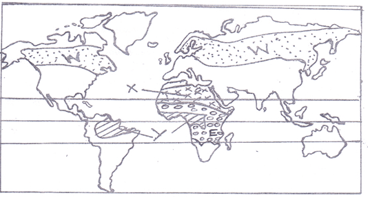
- Identify the vegetation labelled W, X and Y. (3 marks)
Equatorial/ tropical rain forest.
X – Desert vegetation.
W – Coniferous forest. - Describe the adaptive characteristics of the vegetation labeled E on the map. (6 marks)
- The grass dries up in the dry season as a preservation measure against drought and quickly sprouts at the onset of the rains.
- Most trees are thorny to protect them from browsing animals.
- Most trees have long roots to tap underground water.
- Most trees have thin waxy leaves to reduce loss of water through transpiration.
- Most trees are umbrella shaped to provide shade on the ground and thus reduce the rate of evaporation at the root area.
- Some trees such as baobab have thick-fleshy stems to store water.
- Some trees shed their leaves during the dry season to reduce loss of water through transpiration.
- Identify the vegetation labelled W, X and Y. (3 marks)
- Your class is to planning to undertake a field study on vegetation in Mau forest;
- State three preparations you would carry out. (3 marks)
- Seeking permission from the relevant authorities.
- Setting the objectives /and hypotheses.
- Reading more about the topic of study.
- Holding discussions on the topic of study.
- Carrying out a pre-visit.
- Preparing questions and questionnaires to be used during fieldwork for data collection.
- Deciding on means of travelling to the area of study.
- Obtaining a route map.
- Gathering the relevant materials and tools for the fieldwork.
- Conducting sampling in case the area is too large.
- Dividing the class into groups and appointing the group leaders.
- Preparing a working schedule.
- Give three sampling techniques you would use. (3 marks)
- Random sampling.
- Systematic sampling.
- Stratified sampling.
- Cluster sampling.
- Identify four challenges you are likely to face during the actual field study. (4 marks)
- Presence of thick vegetation cover which may hinder movement within the forest.
- Injuries from thorns.
- Tiredness/fatigue due to walking long distances.
- Uncooperative respondents.
- Adverse weather conditions such as heavy rainfall.
- Loss of direction in the forest which may lead to wastage of time.
(Any other topic relevant answer)
- State three preparations you would carry out. (3 marks)
- Differentiate between derived and cultivated vegetation. (2 marks)
-
-
- Differentiate between aridity and desertification (2 marks)
- A dry patch of land deficient in water leading to scarcity of vegetation while desertification is a slow but steady encroachment of desert like condition on to potentially productive agricultural land
- Explain the following processes of wind erosion
- Abrasion (2 marks)
- Wind blows over the desert surface carries a lot of materials like sand, gravel etc.
- The materials grinds, scratch, scrap and polish the rock surfaces in a process called abrasion.
- Deflation (2 marks)
- The process by which wind removes dry unconsolidated material from the earth’s surface
- Fine and light particles are blown away as dust storms
- The heavier materials are rolled along the ground thus lowering the surface to form hollows
- The lighter materials which are air-borne polish the surfaces of the rock outcrops.
- Abrasion (2 marks)
- Differentiate between aridity and desertification (2 marks)
- With a well labelled diagram, describe the formation of a mushroom block. (5 marks)
- A homogeneous rock outcrop lie on the path of the prevailing wind.
- Wind erodes the rock using the materials being transported through abrasion
- More abrasion occurs near the base of the rock where the abrasive material are more leading to a narrow base.
- Eventually a rock block with a narrow base and broad top forms called a mushroom block.
(Text=4mks
Diagram-1mk
Total=5mks
-
- State three factors which influence wind transport (3 marks)
- Presence of obstacles
- Strength and speed of wind
- Amount of load
- Vegetation cover
3 x 1= 3 mks
- Give three characteristics of a Barchan (3 marks)
- windward slope is gentle
- leeward slope is steep
- Made of massive deposition of sand
- it has hornlike slopes on the leeward side
- It experiences eddy currents on the leeward side
- State three factors which influence wind transport (3 marks)
- Form Four students carried out a field study near their school on action of water in arid areas.
- Give three reasons why they required in a route map (2 marks)
- It shows the route to be followed
- Maps help to show the locality of main features
- It enables the researcher to know obstacles likely to be encountered and prepare well to overcome them
- enables a research to prepare a work schedule
- helps the researcher to estimate the distance and prepare a budget
- enables the researcher to estimate time likely to be taken in the field study
- State three problems they are likely to encounter while in the field. (3 marks)
- fatigue due to difficult terrain
- attack by wild animals
- extreme weather conditions ie rainy
- sudden illness
- in accessibility of some areas
- accidents in the field ie falling down
- Name two features that likely to observe (2 marks)
- wadi
- dry river valley
- bajada
- inselbergs / pediments
- mesa
- buttes
- playa
- canyon/gorges
- salinas
- alluvial fans
- Give three reasons why they required in a route map (2 marks)
-
-
- State three factors necessary for the development of Karst scenery. (3 marks)
- Presence of hard and well jointed rocks to allow permeability.
- There surface rock should be thick layers of limestone/ dolomite or chalk.
- The climate should be hot and humid with abundant/ moderate rainfall to facilitate solution.
- The water table should be deep to allow formation of the features.
(Any 3x1=3mks)
- The diagram below shows an Artesian Basin. Use it to answer the question (i) and (ii).
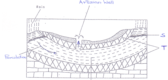
- Name the parts marked S and T. (2 marks)
S- Water table
T- Impermeable rock - State three necessary conditions for the formation of an artesian well. (3 marks)
- The aquifer must be made of the same permeable materials.
- Aquifer must be sandwiched between impermeable rocks.
- Aquifer must outcrop in the region of water intake
- The basin should dip towards a region where land surface is lower than the exposed end/ form a broad syncline/basin.
- The mouth of the well must be lower than the intake area.
(Any 3x1=3mks)
- Explain how a doline is formed. (4 marks)
- Rain water mixes with Carbon IV oxide in the atmosphere to form weak carbonic acid.
- The rain water containing the acid reacts with Calcium carbonate in the limestone rock to form Calcium bi-carbonate which is soluble.
- As the solution percolates into the rock though the joints, the rock is eroded by solution.
- The joints deepen and widen forming small hollows called swallow holes.
- Continued solution widens the hollows so the blocks of rock between the hollows are dissolved completely.
- *The swallow holes join/coalesce forming a large rounded / elliptical depression called a doline.
(6 ticks, steps be clear, *the last point must be there to score max.4mks)
- Name the parts marked S and T. (2 marks)
-
- Give reasons why some lakes are fresh. (3 marks)
- Some are located in areas of high rainfall which supply fresh water and dilute the salts keeping the lakes fresh.
- Some have surface outlets which drain away excess salts from the lakes.
- Some have subterranean outlets which drain off salts from the lakes.
- Some have regular inflow of fresh water from rivers which dilutes the salts in the lakes.
- Some are located in cool areas/areas of low temperatures hence low evaporation rates.
(Any 3 x 1 =3mks)
- Describe how a tarn is formed. (5 marks)
- Snow accumulates in shallow pre-existing hollow/depression on the mountain side.
- The snow gets compacted into ice
- Alternating freezing and thawing deepen the hollow.
- The accumulated ice erodes the hollow by abrasion and plucking making it deep and wide
- Eventually a deep steep-sided depression called a cirque is formed.
- Melt water and rain water collect in the depression to form corrie lake/ tarn.
- Give reasons why some lakes are fresh. (3 marks)
- Explain two negative effects of lakes. (4 marks)
- Excessive rainfall can cause a lake to expand causing its water to spill over flooding of the shores and the surrounding areas.
- The shallow waters of the fresh water lakes provide conducive environment for breeding of pests that causes diseases.
- Lakes can be an obstacle to land transport like roads and railways increasing the distance to be followed.
- Man-made lakes may lead to displacement of people and division of communities.
- Some lakes are habitats for wild animals like hippos which are dangerous to human life and destroy crops.
- Some lakes have saline water that is unsuitable for irrigation, domestic and industrial use.
(Any 2 explained points x 2=4marks)
- State three factors necessary for the development of Karst scenery. (3 marks)
Join our whatsapp group for latest updates
Tap Here to Download for 50/-
Get on WhatsApp for 50/-
Download Geography Paper 1 Questions and Answers - Kassu Joint Mock Examination 2021.
Tap Here to Download for 50/-
Get on WhatsApp for 50/-
Why download?
- ✔ To read offline at any time.
- ✔ To Print at your convenience
- ✔ Share Easily with Friends / Students


