
Instructions to candidates
- This paper consists of two sections; A and B
- Answer all the questions in section A in the spaces provided after each question.
- In section B, answer question 6 and any other two questions.
- Candidates should answer the questions in English.
SECTION A
Answer all the questions in this section
-
- Define the term agroforestry. (2 marks)
- Give three uses of the mangrove trees. (3 marks)
-
- Name two areas where diamonds are mined in South Africa. (2 marks)
- State three negative effects of mining on the physical environment. (3 marks)
-
- Name the spectacular wildlife activity across the Mara river that is considered one of the new wonders of nature. (2 marks)
- State three characteristics of package tourism. (3 marks)
-
- Name two types of railway rail currently operated in Kenya by railway services. (2 marks)
- State three conditions of roads in Kenya that may lead to motor vehicles accidents. (3 marks)
- Below is a map of the Ruhr industrial region in Germany. Use it to answer the questions that follow.
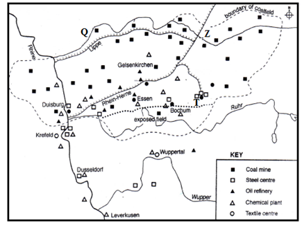
- Name:
- The river marked Q. (1 mark)
- The town marked T. (1 mark)
- The canal marked Z. (1 mark)
- Give two reasons why the Ruhr region has lost some of its importance as an industrial centre in recent years. (2marks)
- Name:
SECTION B
Answer question 6 and any other two questions in this section
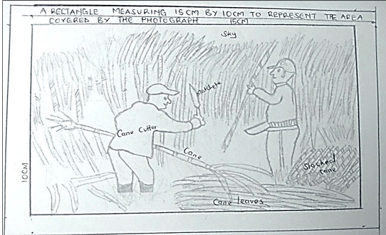
- Study the photograph below and use it to answer questions (a) and (b)
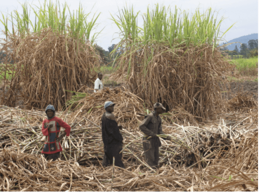
-
- Name the activity taking place in the photograph. (1 mark)
- Identify the type of photograph shown above. (1 mark)
- State three reasons for the identification in (ii) above. (1 mark)
- Identify four safety measures that the people in the photograph have taken as they carry out the above activity. (4 marks)
-
- Draw a rectangle measuring 15cm by 10cm to represent the area covered by the photograph. (2 marks)
- On the rectangle sketch and label four main features shown on the photograph (4 marks)
- Below is a flow chart showing the processing of sugar cane. Study it and answer questions, 6(b) (i) and (ii).
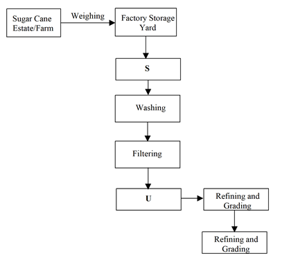
- Name the processes labeled S and U. (2 marks)
- Give two bi-products from the process labeled U. (2 marks)
- Explain three possible solutions to the problem of exploitation by the middle men in sugar cane farming. (6 marks)
-
-
-
- Give two disadvantages of using agro-chemicals as a method of controlling tsetse flies. (2 marks)
- State three physical factors which should be considered when selecting a waste land to be reclaimed for agricultural use. (3 marks)
-
- State three benefits that resulted from the reclamation of Yala swamp. (3 marks)
- Give three advantages of irrigation over rain fed agriculture. (3 marks)
- The map below shows some irrigation schemes in Kenya. Use it to answer questions (c) (i) and (ii).
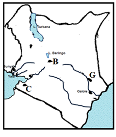
- Name the irrigation schemes above labeled B, C and G. (3 marks)
- State five challenges which the schemes labeled B faces. (5 marks)
-
- Name two main polders in the Netherlands. (2 marks)
- Give four ways in which the polders in the Netherlands have contributed to Horticultural farming in the country. (4 marks)
-
-
-
- Define the term fisheries. (2 marks)
- State two characteristics of pelagic fish. (2 marks)
- The map below shows major world fishing grounds. Use to answer the questions that follow.
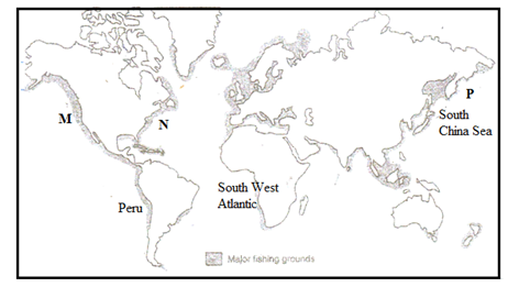
- Identify the two ocean currents that converge in the fishing ground marked P. (2 marks)
- Name two major fishing countries in the South West Atlantic fishing grounds (2 marks)
- State two physical factors favouring fishing in the South West Atlantic fisheries (2 marks)
-
- Identify the fishing method below (1 mark)
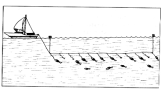
- Describe how the above fishing method is carried out. (4 marks)
- Identify the fishing method below (1 mark)
-
- What is fish cage farming? (2 marks)
- Give two reasons why tilapia is the most common fish species in fish farming. (2 marks)
- Compare fishing in Japan and Kenya under the following subtopics:
- Technology (2 marks)
- Market (2 marks)
- Tradition (2 marks)
-
-
- The sketch map below shows Hydro-Electric power stations along River Tana. Use it to answer the questions that follow.
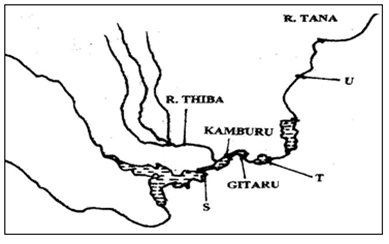
- Identify the hydroelectric power stations marked S and T. (2 marks)
- Name the proposed hydroelectric power station marked U (1 mark)
- State three physical factors that led to the establishment of seven forks hydroelectric power project along river Tana (3 marks)
- What is the name of the multi-purpose hydroelectric power dam recently commissioned by the Ethiopian government on the Blue Nile? (1 mark)
-
- Name three sources of green energy (3 marks)
- Students of Mawingo Secondary School carried out a field study on Geothermal sites in the Kenya Rift Valley. Name three Geothermal potential sites they may have identified. (3 marks)
- Name a method they used to record data
-
- Define biomass (2 marks)
- State four causes of energy crisis. (4 marks)
- Explain three effects of power rationing in Kenya. (6 marks)
- The sketch map below shows Hydro-Electric power stations along River Tana. Use it to answer the questions that follow.
-
- Define the following terms:
- Census (2 marks)
- Infant mortality rate (2 marks)
-
- Explain three efforts taken by the Kenya government to reduce cases of infant mortality. (6 marks)
- State three challenges the Kenyan Government faces in her effort to control the Covid-19 mortality in the country. (3 marks)
-
- Using the table below calculate the inter-census numerical population increase (2 marks)
Year Total population 1979 15,327,061 1969 10,942,705 - Give the meaning of brain drain. (2 marks)
- State three measures that the Kenya government should undertake to check on brain drain. (3 marks)
- Using the table below calculate the inter-census numerical population increase (2 marks)
-
- Name two Scandinavian countries with slow population growth. (2 marks)
- Give three measures taken by the above countries to increase their population growth (3 marks)
- Define the following terms:
MARKING SCHEME
SECTION A
Answer all the questions in this section
-
- Define the term agroforestry (2marks)
- This is the growing of trees, crops and keeping livestock on the same piece of land at the same time.
- Give three uses of the mangrove trees (3 marks)
- absorbs CO2 and purifies the atmosphere
- The bark has tannin used in tanning leather
- Used as firewood
- Timber for construct
- Aesthetic valve / environmental beauty Any 3 x 1 = 3 mks
- Define the term agroforestry (2marks)
-
- Name two areas where diamonds are mined in South Africa (2marks)
- Prestoria
- Koffle
- Jaggersfontein
- Kimberly Any 2 x 1 = 2 mks
- State three negative effects of mining on the physical environment (3 marks)
- pollution of air, water, land and noise
- Dereliction of land/ugly land surface
- Loss of biodiversity
- Disruption/ lowering of the water table
- Leads to soil erosion/degeneration Any 3 x 1 = 3 marks
- Name two areas where diamonds are mined in South Africa (2marks)
-
- Name the spectacular wildlife activity across the Mara river that is considered one of the new wonders of nature (2 marks)
- Wild beast migration
- State three characteristics of package tourism (3marks)
- The tourists travel in large numbers
- The tour is organized by an agency
- The tourist enjoy similar facilities
- The prices are fairly low 3 x 1 = 3 marks
- Name the spectacular wildlife activity across the Mara river that is considered one of the new wonders of nature (2 marks)
-
- Name two types of railway rail currently operated in Kenya by railway services. (2mark)
- Meter gauge
- Standard gauge Any 2 x 1
- State three conditions of roads in Kenya that may lead to motor vehicles accidents (3marks)
- Missing road sign
- Pot holes
- Sharp bends
- Narrow roads
- Misty /toppy or dusty conditions that reduce visibility
- Steepness
- Slippery conditions Any 3 x 1 = 3 marks
- Name two types of railway rail currently operated in Kenya by railway services. (2mark)
-
- Below is a map of the Ruhr industrial region in Germany
Name the:- The river marked Q
- Q – River lippe
- The town marked T
- T – Dortmund
- The canal marked Z
- Z – Dortmund Elms
- The river marked Q
- Give two reasons why the Ruhr region has lost some of its importance as an industrial centre in recent years. (2marks)
- The decline of use of coal as a source of energy in the industries
- Depletion of prime minerals especially coal and iron ore in the region
- Competition for activities from upcoming industrial areas. 2 x 1 = 2 marks
- Below is a map of the Ruhr industrial region in Germany
SECTION B
Answer question 6 and any other two questions from this section
- Study the photograph below and use it to answer questions (a)
-
- Name the activity taking place in the photograph (1mark)
- Sugarcane harvesting/ Cane cutting
- Identify the type of photograph shown above (1mark)
- Ground general view
- State three reasons for the identification above (3marks)
- A large area is covered
- Many features are shown
- The features diminish in size as one moves to the background
- The photograph has three parts, the fore ground, middle and back. 3 x 1 = 3 marks
- Identify four safety measures that the people in the photograph have taken as they carry out the above activity (4marks)
- Hands covered with gloves
- Gum boots to protect from sharp stumps stalks
- Cap to protect them from strong shine
- Bright cover all for easy identificatio
- Working at a distance from each other 4 x 1 = 4 marks
- Name the activity taking place in the photograph (1mark)
-
- Draw a rectangle measuring 15cm by 10cm to represent the area covered by the photograph(2marks)
- On the rectangle sketch and label four main features shown on the photograph (4 marks)
- Below is a flow chart showing the processing of sugar cane. Study it and answer questions,6(b)(i) and (ii)
- Name the processes labeled S and U (2marks)
- U – boiling / Crushing of cane
- S – evaporation
- Give two by-products from the process labeled U (2marks)
- Molasses
- Sugar wax
- Explain three possible solutions to the problem of exploitation by middle men in sugar cane farming (6marks)
- Formation of farmers’ co-operative societies to help them market their produce.
- Contract signing as out growers to ensure direct payment by sugar companies.
- Direct individual delivery by the farmer to any sugar factory. 3x2=6 marks
- Name the processes labeled S and U (2marks)
-
-
-
- Give two disadvantages of using agro-chemicals as a method of controlling tse tse flies. (2marks)
- May kill unintended organisms hence creating imbalance in biodiversity
- May cause soil, air and water pollution.
- Some contribute in the destruction of the ozone layer.
- Tse tse flies may develop immunity to insecticides hence becoming uncontrollable
2 x 1 =2 marks
- State any three physical factors which should be considered when selecting a waste land to be reclaimed for agricultural use (3marks)
- The size of the area is big enough to justify reclamation
- Soil fertility to minimize the cost of improving on them
- The climate – this should be suitable for the intended crop
- Terrain – Should be gentle / undulating for mechanization
- Pests and diseases – The area should have a low incidence of pests and diseases which lower production. 3 x 1 = 3 marks
- Give two disadvantages of using agro-chemicals as a method of controlling tse tse flies. (2marks)
-
- State three benefits that resulted from the reclamation of Yala swamp (3marks)
- Control of floods in the area
- Increased agricultural output i.e rice, maize
- Stimulated employment opportunities and raised standards of living.
- Increase of land for agriculture and settlement
- Controlled the cases of waterborne diseases i.e Malaria and bilhazia
- Opened up the remote area as roads, schools come up any 3 x 1 = 3 marks
- Give three advantages of irrigation over rain fed agriculture (3 marks)
- Cultivation can be done all year round
- River water contains fertile silt
- Enables cultivation of marginal dry areas.
- The irrigation dams may have other uses i.e H.E.P production
- Free of flooding as the amount of water is controlled. any 3 x 1 = 3 marks
- State three benefits that resulted from the reclamation of Yala swamp (3marks)
- The map below shows some irrigation schemes in Kenya. Use it to answer question c(i) and c(iii)
- Name the irrigation schemes above labeled B,C and G (3marks)
- B – Perkerre
- C – West kano
- G – Bura any 3 x 1 = 3 marks
- State five challenges which the schemes labeled B faces (5marks)
- Low fluctuation of water during the dry season
- Siltation of canals increasing cast of dredging
- Rapid growth of weeds which lower crop production
- High evaporation rates leading to salinization of soils.
- Flooding during heavy rains
- Tribal conflict between the Tugen and pastrolist Ngemps
- Conflict with the National irrigation board over titles for land ownership. any 5 x 1 = 5marks
- Name the irrigation schemes above labeled B,C and G (3marks)
-
- Name two main polders in the Netherland
- The zulder zee (South sea) any 2 x 1 = 2marks
- Give four ways in which the polders in the Netherlands have contributed to Horticultural farming in the country. (4 marks)
- The polders have fertile soils from the sea bed used in horticulture farming.
- The polders have increased area of land for large scale horticulture production.
- The fresh water lakes created in the area i.e lake Yssel provide water for irrigation and desalinization of soils.
- The polders are gentle/undulating allowing for mechanization.
- The walls of the dykes are used as roads to transport the produce to the market.
Any 4 x 1=4marks
- Name two main polders in the Netherland
-
-
-
- Define the term fisheries (2 marks)
- Fisheries are water bodies where aquatic organisms/fish are reared for exploitation
- State two characteristics of pelagic fish (2 marks)
- They are small in size
- Found near the surface
- Live in groups shoals
- Are migratory any 2 x 1 = 2marks
- Define the term fisheries (2 marks)
- The map below shows major world fishing grounds. Use to answer the questions that follow.
- Identify the two Ocean currents that converge in the fishing ground marked P. (2marks)
- The cold oya siwo and warm kuro siwa
- Name two major fishing countries in the South West Atlantic fishing grounds (2marks)
- South Africa
- Namibia
- Angola
- State two physical factors favouring fishing in the S.W Atlantic fisheries (2marks)
- The Coast is washed by the cold bengwela current
- The Coast is indented i.e in walvis bay in Namibia
- Shallow broad continental shelf which allows sunlight infiltration for plankton growth.
any 2 x 1 = 2 marks
- Identify the two Ocean currents that converge in the fishing ground marked P. (2marks)
-
- Identify the fishing method below (1mark)
- Commercial long line
- Describe how the above fishing method is carried out (4 marks)
- There is a long line about meters pulled by a boat.
- The long line has floats at the top from the long line are several small lines which are hooked at the end and baited
- The fish are trapped by their gills when they try to eat the bait.
- After sometimes the lines are pulled out of water and the fish emptied. any 4 x 1 = 4 marks
- Identify the fishing method below (1mark)
-
- What is fish cage farming (2 marks)
- This is the rearing of fish in water bodies using cage like structures 2 x 1 = 2marks
- Give two reasons why tilapia is the most common fish species in fish farming (2 marks)
- It breeds fast
- Resistant to diseases
- Most palatable (liked)
- Can survive in different environment 2 x 1 = 2 marks
- Compare fishing in Japan and Kenya under the following subtopics (2 marks)
- Technology
- The japan uses modern boats with refrigerator in deep waters while Kenya use simple boats in the shallow waters.
- Market
- The fish caught in Japan is for domestic and mainly export, Kenya is mainly for domestic market
- Tradition
- The Japanese have a seafaring tradition while in Kenya only the communities, around the Lake and the sea engage in major fishing
- Technology
- What is fish cage farming (2 marks)
-
-
- The sketch map below shows Hydro-Electric power stations along River Tana
- Identify the H.E.P stations marked Sand T (2 marks)
- S – Masinga station
- T – Kindaruma station
- Name the proposed H.E.P station marked U (1 mark)
- U – Mutonga
- State three physical factors that led to the establishment of seven forks hydroelectric power project along river Tana (3 marks)
- Regular and constant supply of water from River Tana
- Presence of large volume of water from River Tana
- Presence of hard basement rock that provided foundation for dam and power house construction.
- Presence of rapids and waterfalls that provided steep gradient (hydraulic head) for H.E.P production.
- Presence of deep and steep narrow gorges that provided enough space for large reservoirs and reduced cost of dam construction. 3 x 1 = 3marks
- What is the name of the Multi purpose H.E.P dam recently commissioned by the Ethiopian government on the blue Nile. (2marks)
- Grand Ethiopian Renaissance Dam
- Identify the H.E.P stations marked Sand T (2 marks)
-
- Name three sources of green energy (3marks)
- Sun
- Geothermal steam
- Water tides/waves
- Wind
- Biomass 3 x 1 = 3 marks
- Students of Mawingo Secondary school carried out a field study on Geothermal sites in the Kenya Rift Valley. Name three Geothermal potential sites they may have identified (3marks)
- Ol karia
- Suswa
- Lake bagoria and Magadi
- Longanol
- Eburu
- Mai Mahiu
- Menegai crater
- Name a method they used to record data (1mark)
- Video taping
- Photographing
- Field sketching 1 x 1 = 1mark
- Name three sources of green energy (3marks)
-
- Define the term Biomas? (2marks)
- Biomas are energy sources derived from organic matter 2x 1 = 2 marks
- What is energy crisis? (2 marks)
- This refers to a situation where the prices of fossil fuels rises uncontrollably as a result of demand surpassing supply. 2 marks
- Define the term Biomas? (2marks)
- Explain three effects of power rationing in Kenya (6 marks)
- Unemployment due to closure of industries leading to inability to pay workers.
- Slow industrial growth due to low energy to run machines in industries
- Drainage of foreign exchange from important of energy to cater for the shortage.
- Discourage foreign investors in the country because there is uncertainty of the future growth for their investments.
- Lowers the number of tourists in the country because their desired comfort offered by power is lacking.
- Reduction in government revenue got from taxation of goods from industries and from payments of consumed energy 3 x 2 = 6 marks
- The sketch map below shows Hydro-Electric power stations along River Tana
-
- Define the following terms (2marks)
- Census
- This is the official count of all persons in a defined area at a specific time
- Infant mortality rate (2marks)
- This is the number of children who die before attaining the age of one year
- Census
-
- Explain three efforts taken by the Kenya government to reduce cases of infant mortality (6marks)
- Improved nutrition, free children feeds given by the ministry of health.
- Mandatory prenatal and post natal clinic attendance to monitor child and mother and to take immunization
- Issuance of the malaria testing, drugs and nets to expectant mothers.
- Educating mothers on the importance of breast feeding and spacing children
3 x 2 = 6 marks
- State three challenges the Kenyan Government faces in her effort to control the Covid-19 mortality in the country (3marks)
- Mutation of the disease into new variants
- Corruption i.e embezzlement of donor funding by corrupt Government officials
- Limited donor support
- Uncooperative citizens towards Covid -19 containment measures. any 3 x 1 =3marks
- Explain three efforts taken by the Kenya government to reduce cases of infant mortality (6marks)
-
- Using the table below calculate the inter-census numerical population increase (2marks)
Year Total population 1979 15,327,061 1969 10,942,705 - Give the meaning of the term Brain drain (2marks)
- The migration of highly trained or qualified people from a particular country 2 x 1 = 2 marks
- State three measures that the Kenya government should undertake to check on Brain drain (3marks)
- Offer higher salary perks to the skilled man power
- Improving working conditions in their work places i.e safety
- Sponsoring them to take further studies locally and abroad.
- Educating them to be patriotic and help build their county. 3 x 1 = 3 marks
- Using the table below calculate the inter-census numerical population increase (2marks)
-
- Name two Scandinavian countries with slow population growth (2 marks)
- Norway
- Sweden
- Denmark
- Finland
- Ice land Any 2 x 1 = 2 marks
- Give three measures taken by the above countries to increase their population growth (3marks)
- Prolonged maternity for the women and also men as an incentive to give birth to more children
- The government give free medical services, tax help to the mother and child
- Educating the public on the need to have more children so as to reduce dependency on migrant workers.
- Free education to the children up to the university. 3 x 1 = 3 marks
- Name two Scandinavian countries with slow population growth (2 marks)
- Define the following terms (2marks)
Join our whatsapp group for latest updates
Tap Here to Download for 50/-
Get on WhatsApp for 50/-
Download Geography Paper 2 Questions and Answers - Bondo Mocks 2021 Exams.
Tap Here to Download for 50/-
Get on WhatsApp for 50/-
Why download?
- ✔ To read offline at any time.
- ✔ To Print at your convenience
- ✔ Share Easily with Friends / Students


