
INSTRUCTIONS TO CANDIDATES
- This paper has two sections: A and B
- Answer all the questions in section A
- Answer question 6 and any other two questions from section B
- This paper consists of 6 printed pages. Ensure ALL the 10 questions are printed.
For examiners use only
|
|
SCORE |
|
SECTION A |
|
|
QUESTION 6 |
|
|
QUESTION 7 |
|
|
QUESTION 8 |
|
|
QUESTION 9 |
|
|
QUESTION 10 |
|
|
TOTAL MARKS |
|

QUESTIONS
SECTION A.
-
- Define the following terms.
- Geography (1mk)
- Habitat (1mk)
- Give three branches of geography. (3mks)
- Define the following terms.
-
- Name two elements of weather that can be recorded at a school station. (2mks)
- Give three reasons why the recording of data at a school station may be inaccurate. (3mks)
-
- What is a hydrological cycle (2mks)
- State three factors that influence the amount of surface run-off. (3mks)
- Use the diagram below to answer questions that follow.
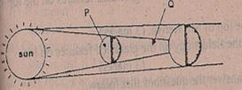 What type of eclipse is represented by the diagram? (1mk)
- Name the parts marked P and Q (2mks
- what is the effect of the international date line on crossing the line? (2mks)
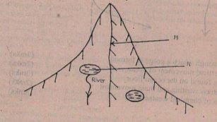
- The diagram represents zones of natural vegetation on a mountain in Africa. Use it to answer Question (a)
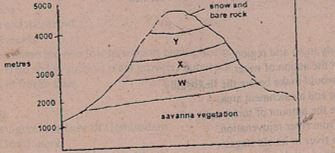
- Name the vegetation zones marked W, X, & Y.
- Give two reasons why mountains tops have no vegetation
SECTION B:ANSWER QUESTION SIX AND ANY OTHER TWO QUESTIONS .(75MKS)
- Study the map of Kisumu East 1:50,000 (sheet 116/2) provided and answer the following questions.
-
- Give the four figure grid reference of Obwolo school. (1mk)
- What is the approximate height of point 000960? (1mk)
- Name two physical features found at grid square 0384. (2mks)
- Name two types of natural vegetation in the area covered by the map (2mks
- Calculate the area of the Kisumu municipality. Give your answer in square kilometers (km²) (2mks)
- Measure the length of the all-weather road(bound surface) from the junction at grid reference 974911 to the edge of the map, grid reference 950968 (2mks)
- Citing evidence, give three social functions of Kisumu town. (6mks)
-
- Using a scale of 1cm to represent 200 metres, draw a cross-section from grid reference 970980 to 030989. (4mks)
- On it mark and name the following
- Steep slope (1mk)
- Motor able road (1mk)
- Nyangori river (1mk)
- Calculate the vertical exaggeration. (2mks)
-
-
-
- Define the term folding (2mk)
- State three factors that influence folding. (3mks)
-
- Briefly describe the continental drift theory. (5mks)
- State 2 evidences supporting the above theory of continental drift. (2mks)
-
- Using a well labelled diagram, explain how conventional currents theory may lead to formation of Fold Mountains. (6mks)
- Highlight the signifance of Fold Mountains to human activities. (5mks)
- Give two theories that explain the formation of Fold Mountains apart from convectional currents theory. (2mks)
-
-
- Define the following terms
- Glaciation (1mk)
- Ice-berg (1mk)
- Give two reasons why there are no ice sheets in Kenya (2mks)
- The diagram below shows a glaciated landscape use it to answer questions that follow.
- Identify the feature labelled M and N (2mks)
- Name two process through which N is formed. (2mks)
- Describe how feature marked N is formed. (5mks)
-
- Name two types of moraines. (3mks)
- Explain two factors that determine the speed of ice movement. (4mks)
- Students from a school near Mt. Kenya were planning to carry out afield study of the glaciated features on top of the mountain.
- State two reasons why they needed a route map. (2mks)
- Give three challenges they would likely face during their field study. (3mks)
- Define the following terms
-
-
- Define the term underground water. (1mk)
- Give three sources of underground water. (3mks)
- Explain 3 factors that influence the occurrence of underground water. (6mks)
- The diagram below shows an artesian well.
- Name the parts marked X and Y. (2mks)
- State four conditions necessary for the formation of artesian wells. (4mks)
- Explain two significance of underground water to human activities. (4mks)
- You intend to carry out a field study in a Karst landscape.
- Give two reasons why it is necessary to carry out a pre-visit before the study. (2mks)
- Give three follow –up activities that you were engaged in after the actual study.(3mks)
-
-
-
- Name three factors that influence the formation of soil. (3mks)
- Name three processes of soil formation. (3mks)
- Apart from texture, name other properties of soil. (3mks)
-
- What is soil degeneration? (2mks)
- Explain three ways in which farming practices may lead to loss of soil fertility.(6mks)
- State how soil acidity is reduced. (2mks)
-
- Draw a simple – labelled diagram of profile of a mature soil. (4mks)
- Distinguish between soil profile and soil catena. (2mks)
-
MARKING SCHEME
-
- Define the following terms.
- Geography (1mk)
- The scientific study of earth as the home of mankind
- Study of distribution and interrelationship of the natural and human phenomena on earth’s surface
- Habitat (1mk)
- Physical condition that influence development and behavior of living organisms
- Geography (1mk)
- Give three branches of geography.(3mks)
- Physical geography
- Human
- Practical Geography
- Define the following terms.
-
- Name two elements of weather that can be recorded at a school station.(2mks)
- Wind
- Rain
- Temperature
- Humidity
- Sunshine
- Atmosphere pressure
- Cloud cover
- Give three reasons why the recording of data at a school station may be inaccurate. (3mks)
- Human error
- Interference with instruments
- Poor siting of weather stations
- Extreme weather conditions
- Natural calamities
- Name two elements of weather that can be recorded at a school station.(2mks)
-
- What is a hydrological cycle(2mks)
- Hydrological cycle is the continuous interchange of water in a cycle between water bodies land and the atmosphere.
- State 3 factors that influence the amount of surface run-off. (3mks)
- Amount/Nature of rainfall
- Gradient of the land
- Nature of rocks/soil
- Water table/level of soil/saturation
- Vegetation cover
- Human activities
- What is a hydrological cycle(2mks)
- Use the diagram below to answer questions that follow.
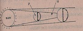
- What type of eclipse is represented by the diagram? (1mk)
- Solar eclipse
- Name the parts marked P and Q(2mks
- P – Moon
- Q – umbra
- What is the effect of the international date line on crossing the line?(2mks)
- On crossing this longitude while going to the east, a day is gained while crossing to the west a day is lost.
- What type of eclipse is represented by the diagram? (1mk)
- The diagram represents zones of natural vegetation on a mountain in Africa. Use it to answer Question (a)
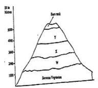
- Name the vegetation zones marked w,x,& y.
- W-Rainforest
- X-Bamboo
- Y- Health and Moorland
- Give two reasons why mountains tops have no vegetation
- Temperatures are two low to spport plant growth
- There is thin soil/no soil to support plant growth/bare rock.
- Water is in frozen state
- Name the vegetation zones marked w,x,& y.
-
-
- Give the four figure grid reference of Obwolo school.(1mk)
- 9995
- What is the approximate height of point 000960?(1mk)
- 1200m
- Name two physical features found at grid square 0384.(2mks)
- River
- River Valley
- Seasonal swamp
- Name two types of natural vegetation in the area covered by the map(2mks)
- scattered trees
- Scrub vegetation
- Woodland vegetation
- Papyrus swamp vegetation
- Give the four figure grid reference of Obwolo school.(1mk)
- Calculate the area of the Kisumu municipality. Give your answer in square kilometers (km²) (2mks)
- Full squares =5
- Half square =17/2
- = 5 + 17/2 =13.5 km² - +0.5
- Measure the length of the all-weather road(bound surface) from the junction at grid reference 974911 to the edge of the map, grid reference 960959.(2mks)
- 5.4km + 0.1
- (5.3 – 5.5 km)
- Citing evidence explain three social functions of Kisumu town.(6mks)
- Water supply centre evidenced by water works
- Education center evidenced by prison
- Health center evidenced by a school
- Religious center evidenced by church
- Administrative center evidenced by prison
-
- Using a scale of 1cm to represent 200 metres, draw a cross-section from grid reference 970980 to 030989. (4mks)
- On it mark and name the following
- Steep slope(1mk)
- Motor able road(1mk)
- Nyangori river(1mk)
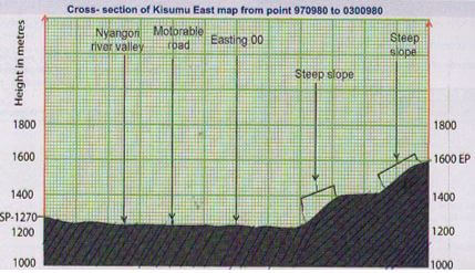
(T-1mrk, y-1mk, SP and EP-1mk, labelled y axis- 1mk)
- Calculate the vertical exaggeration.(2mks)
- V.E= Vertical scale
- Horizontal scale
- 1/200m ÷ 1/500
1/200m x 500/1 = 2.5 times
-
-
-
- Define the term folding(2mk)
- Folding is the bending or distortion of crustal rocks which make them bend upwards and downwards due to compressional forces.
- State three factors that influence folding.(3mks)
- Rock type/flexibility or elasticity of a rock
- Strength or intensity of the compressional forces
- Temperature within rocks
- The age of sedimentary rocks
- Define the term folding(2mk)
-
- Briefly describe the continental drift theory. (5mks)
- It states the earth was initially a large land mass called Pangae. It was surrounded by a great sea called panthalasa
- Later pangea broke up into two blocks namely Laurasia and Gondwanaland.The blocks were separated by a narrow sea called Tethys – Eventually laurasia broke and formed the Northern continents e.g Europe and America while Gondwanaland formed southern like Africa
- State 3 evidences supporting the above theory of continental drift.(3mks)
- The jig – saw fit of continental margins
- Geological /structure
- Sea floor spreading
- Climatology
- Distribution of ancient glacial deposits
- The mid atlantic ridge
- Paleontological evidences
- Palaeomagnetic studies
- Briefly describe the continental drift theory. (5mks)
-
- Using a well labelled diagram, explain how conventional currents theory may lead to formation of fold mountains.(6mks)
- The hot molten mantle rocks has convectional currents that move in a circular motion from the bottom towards the crust.
- The currents exert a frictional drag on the sima rocks
- This make the crustal rock to move horizontally which generates the compressional forces .
- The compressional forces squeeze sedimentary rocks materials which bend to form fold mountains.
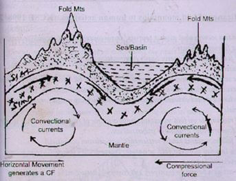
D-2mks
T-4mks
- Highlight the signifance of Fold Mountains to human activities. (4mks)
- Fold mountains provide beautiful scenery that attract tourist hence bring foreign exchange
- Wind ward slopes of fold mountain receive heavy precipitation rainfall which encourage settlement/agriculture
- Some fold mountains have exposed valuable mineral deposits which are mined for income/industrial raw materials
- Some fold mountains act as a barrier to transport and communication lines difficult and expensive.
- Rugged nature of Folds Mountains hinder settlement/agricultural activities.
- Give two theories that explain the formation of Fold Mountains apart from convectional currents theory.(2mks)
- Contraction theory
- Plate tectonics theory
- Using a well labelled diagram, explain how conventional currents theory may lead to formation of fold mountains.(6mks)
-
-
- Define the following terms
- Glaciation(1mk)
- Process through which moving ice erodes,transport and deposits material on the earth’s surface to form glacial features
- Ice-berg(1mk)
- A large block of ice broken from ice sheets and floating in seas/oceans
- Glaciation(1mk)
- Give two reasons why there are no ice sheets in Kenya(2mks)
- Kenya experiences high temperatures under which ice cannot form
- Most parts of Kenya have low altitude/lowlands.
- Kenya is found at low latitude regions/equatorial areas
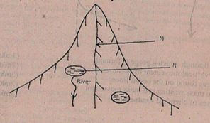
- The diagram below shows a glaciated landscape use it to answer questions that follow.
- Identify the feature labelled M and N (2mks)
- M- Arete
- N- Tarn/corrie lakes/ cirque lake
- Name two process through which N is formed.(2mks)
- Plucking process
- Abrasion process
- Describe how feature marked N is formed.(5mks)
- Snow accumulates in a pre-existing hallow on a mountain side
- Snow gets compacted into ice to form cirque glacier
- Through abrasion the floor aand the sides are eroded deepening the hollow
- Plucking process erodes the back walls steepening them
- A series of these processes results to formation of deep arm –shaped depression called corrie
- The depression filled melt water to form a lake called a tarn
- Identify the feature labelled M and N (2mks)
-
- Name two types of moraines.(3mks)
- Lateral moraine
- Media moraine
- Terminal moraine
- Ground/sub-glacial moraine
- Recessional moraine
- Glacial moraine
- Explain two factors that determine the speed of ice movement.(4mks)
- Temparature changes
- Width of the glacier channel
- Thickness and height of the glacier
- Gradient of the slope
- Nature of the rock surface/friction
- Name two types of moraines.(3mks)
- Students from a school near Mt. Kenya were planning to carry out afield study of the glaciated features on top of the mountain.
- State two reasons why they needed a route map.(2mks)
- To identify direction to take
- To estimate distance they would cover
- To estimate time they are likely to take
- To plan a schedule of a activities/working programme
- Give three challenges they would likely face during their field study. (3mks)
- Ice – accumulation may hinder transportation
- Steep landcape making roads impassible
- Attack by wild animals eg. snakes.
- Accidents may occur eg. falling due to the steep slopes
- State two reasons why they needed a route map.(2mks)
- Define the following terms
-
-
- Define the term underground water.(1mk)
- It is water that is found beneath the earth surface
- Is water found in the pores of a permeable rock underground and above an impermeable rock layer.
- Give three sources of underground water.(3mks)
- Rain water
- lakes /seas/rivers
- Melt water/melting ice
- Magmatic water/plutonic water
- Explain 3 factors that influence the occurrence of underground water. (6mks)
- Evaporation rate- high evaporation leads to less infiltration
- Low evaporation leads to more infiltration
- Level of ground saturation – dry soil absorb more water to make underground water while saturated& wet soils have little infiltration.
- Vegetation cover- presence of vegetation cover reduce run-off//hold water on the ground & water has enough time to infiltrate, while bare grounds has more run-off hence little infiltration.
- Amount of precipitation/rainfall.
- Slope/gradient- flat ground has more infiltration as water remains in place and has enough time to sink steep slopes have ru-off and little water infiltration.
- Define the term underground water.(1mk)
- The diagram below shows an artesian well.
- Name the parts marked X and Y.(2mks)
- x – Aquifer/permeable rock
- y – Impermeable rock
- State four conditions necessary for the formation of artesian wells.(4mks)
- The mouth of the well must be lower than the water intake area for water to flow out naturally.
- The artesian well be sunk to reach below water table in the permeable rock for it to have water permanently.
- Permeable rock/aquifer must be sandwiched between two impermeable rocks to hold water.
- The permeable rock/aquifer must outcrop in a region of adequate water supply/high rainfall/ a lake bed in order to absorb water of underground water.
- Explain two significance of underground water to human activities. (4mks)
- Form springs which are a source of rivers that provide water for domestic/industrial/irrigation uses.
- Underground water forms oasis/wells that provide water for domestic/industrial uses.
- Underground water sustains growth of crops/plant animal life.
- Spring /oasis/wells attract settlement/development of towns
- Hot springs/geysers formed by underground water during vulcanicity are used to generate geothermal power
- Name the parts marked X and Y.(2mks)
- You intend to carry out a field study in a Karst landscape.
- Give two reasons why it is necessary to carry out a pre-visit before the study. (2mks)
- To familiarizes the students with the area
- To determine the suitability of the area of study
- To estimate the cost of study and plan accordingly.
- To identify any problem is likely to encounter during the study
- It is useful in designing a working schedule
- Give three follow –up activities that you were engaged in after the actual study.(3mks)
- Discussing the findings
- Drawing sketches
- Analyzing the data
- Interpreting the data
- Writing reports
- Give two reasons why it is necessary to carry out a pre-visit before the study. (2mks)
-
-
-
- Name three factors that influence the formation of soil. (3mks)
- Parent material
- Time
- Climate
- Living organisms
- Gradient/relief
- Name three processes of soil formation.
- Lateralization
- Humification
- Salinization
- podzolisation
- Name three factors that influence the formation of soil. (3mks)
- Apart from texture, name other properties of soil. (3mks)
- Thickness
- Water
- Porosity
- Colour
- Temperature
- Lime content
-
- What is soil degeneration? (2mks)
- It is the loss of soil fertility or soil deterioration/decline in usefulness of soil due to physical chemical and biological factors.
- Explain three ways in which farming practices may lead to loss of soil fertility.(6mks)
- Overgrazing leads to removal of vegetation exposing soil to agent of erosion.
- Frequent ploughing –weaken soil structure & make it easy for agents of soil erosion.
- Burning crop remains and bushes destroy, organic matter.
- Over use of agro – chemicals – change soil P.H and make it poor.
- Plough up and down the slope create channels for run-off which takes away soil nutrients.
- State how soil acidity is reduced. (2mks)
- Adding lime content i.e calcium hydroxide to the soil
- Draining of swampy/stagnant environment to improve soil aeration
- Planting of water tolerant/sapping plants in swampy zones to improve the drainage condition.
- What is soil degeneration? (2mks)
-
- Draw a simple – labelled diagram of profile of a mature soil. (4mks)
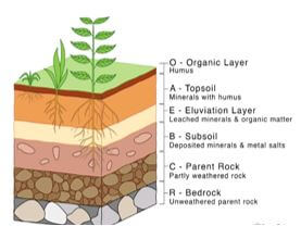
- Distinguish between soil profile and soil catena.(2mks)
- Soil profile is the vertical/arrangement of different layers of soil from the surface to the bed rock while soil catena is the sequence of different soils layers down a slope.
- Draw a simple – labelled diagram of profile of a mature soil. (4mks)
-
Join our whatsapp group for latest updates
Tap Here to Download for 50/-
Get on WhatsApp for 50/-
Download Geography Paper 1 Questions and Answers - MECS Pre Mock Exams 2023.
Tap Here to Download for 50/-
Get on WhatsApp for 50/-
Why download?
- ✔ To read offline at any time.
- ✔ To Print at your convenience
- ✔ Share Easily with Friends / Students