
QUESTIONS
-
- Define the term rotation of the earth ( 2 mks)
- State three effects of revolution ( 3 mks)
-
- Apart from simple symmetrical fold, Name three types of folds ( 3 mks)
- Name two fold mountains in Africa ( 2 mks)
-
- Use the diagram below to answer the following question.
Identify and name the parts labelled P, Q & R ( 3mks)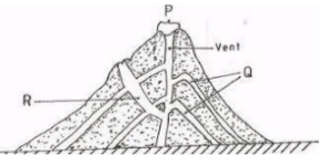
- List two intrusive features as a result of vulcanicity ( 2 mks)
- Use the diagram below to answer the following question.
-
- Give the three main types of river erosion ( 3 mks)
- State two conditions for river capture to take place ( 2 mks)
-
- Define the term Ice berg ( 2 mks)
- List three types of moraine ( 3 mks)
- Study the Map of Kisumu East 1: 50 000 (sheet 116/2) provided and answer the following questions
-
- Apart from topographical maps name two other types of maps. (2m) (1 X2=2m)
- What is the trigonometrically station at grid reference 081980 from the rock outcrop at grid reference 091992. (2m)
- Measure the length of the all-weather road bound surface B from the grid reference 974911 to the edge of the map, grid reference 947967. Give your answer in Kilometers. (2m)
- Describe the relief of the area covered by the map (5m)
- Citing evidence from the map give three economic activities apart from crop growing carried out in the area covered by the map. (4m)
- Students from the school at Masogo (grid square 0681) carried out a field study of the course of river Ombeyi
- State four findings they are likely to come up with. (4m)
- State three advantages of studying rivers through fieldwork. (3m)
- What problems were the students likely to face during their field study? (3m)
-
-
-
- Describe the following characteristics of minerals:
- Texture (1mk)
- Tenacity
- Describe how mechanically formed sedimentary rocks are formed. (4mks)
- Describe the following characteristics of minerals:
- For each of the following rocks, name the resultant rock that forms after metamorphism.
- Sandstone (1mk)
- Limestone (1mk)
- Granite (1mk)
- The diagram shows the rock cycle. Study it and answer the questions that follow.
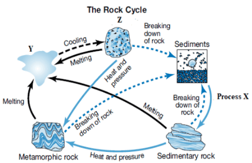
Identify the following:- Process X (1mk)
- Material Y (1mk)
- State three characteristics of rock Z (3mks)
- Explain the economic significance of rocks in Kenya under the following sub-headings.
- Tourism (2mks)
- Agriculture (2mks)
- Industry (2mks)
- Students carried out a field study on rocks around their school.
- State two importance of stating the objectives for their study. (2mks)
- Give three reasons why they prepared a route map of the study area.(3mks)
-
-
-
- Define the term vegetation (2m)
- Draw a well labelled diagram showing the vegetation zones found on the mountain zone. (5m)
- Describe four adaptations of succulent perennials of tropical desert vegetation. (4m)
- Form four students carried out a field study on a tropical rain forest in a certain area in Africa.
- Name three hardwood tree species they are likely to observe. (3m)
- Formulate a hypothesis for their study. (2m)
- State three methods of recording data that the students used in their field study. (3m)
-
-
- Define the term Oceans ( 2 mks)
- Name four features formed as a result of wave deposition ( 4 mks)
- State five differences between oceans and seas ( 5 mks)
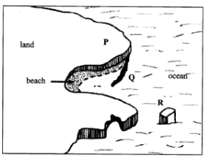
- Describe the formation of a cave ( 4 mks)
- Identify and name the features marked P, Q, & R ( 3 mks)
- Give three main types of submerged upland coasts ( 3 mks)
- Explain two negative significance of coasts and coastal features ( 4 mks)
MARKING SCHEME.
SECTION A
-
- Define the term rotation of the earth ( 2 mks)
- The spinning of the earth on its axis from west to east. ( takes 24 hrs to complete one rotation)
- State three effects of revolution ( 3 mks)
- Revolution causes lunar eclipse
- Revolution causes the four seasons
- Revolution causes changes in midday sun in different times of the year
- Revolution causes changes in length of the day at different times of the year
- Define the term rotation of the earth ( 2 mks)
-
- Apart from simple symmetrical fold, Name three types of folds ( 3 mks)
- Asymmetrical fold
- Overfold
- Isoclinal fold
- Recumbent fold
- Overthrust fold/Nappe
- Anticlinorium-synclinorium complex
- Name two fold mountains in Africa ( 2 mks)
- Atlas
- Cape ranges
- Apart from simple symmetrical fold, Name three types of folds ( 3 mks)
-
- Use the diagram below to answer the following question.
Identify and name the parts labelled P, Q & R ( 3mks)- P- Crater
- Q- Lava layers
- R- subsidiary/side vent
- List two intrusive features as a result of vulcanicity ( 2 mks)
- Dyke
- Sill
- Laccolith/laccolite
- Lopolith
- Phaccolith/phacolite
- Batholith
- Use the diagram below to answer the following question.
-
- Give the three main types of river erosion ( 3 mks)
- Vertical erosion
- Lateral erosion
- Headward erosion
- State two conditions for river capture to take place ( 2 mks)
- The powerful river and misfit river must flow in adjacent valleys
- The pirate river should have a wider valley than the misfit river
- The pirate river must have more active headward erosion than the neighbouring river.
- The pirate river ought to be flowing at a lower level
- Give the three main types of river erosion ( 3 mks)
-
- Define the term Ice berg ( 2 mks)
- Permanent floating ice in large waterbodies
- List three types of moraine ( 3 mks)
- Recessional moraine
- Ground moraine
- Lateral moraine
- Medial moraine
- Terminal moraine
- Define the term Ice berg ( 2 mks)
- Study the Map of Kisumu East 1: 50 000 (sheet 116/2) provided and answer the following questions
-
- Apart from topographical maps name two other types of maps. (2m)
- Sketch maps
- Atlas maps (1 X2=2m)
- What is the trigonometrically station at grid reference 081980 from the rock outcrop at grid reference 091992. (2m)
- 1390 (+ or – 10) (1380 – 1400) (2 X1=2m)
- Measure the length of the all-weather road bound surface B from the grid reference 974911 to the edge of the map, grid reference 947967. Give your answer in Kilometers. (2m)
- 7.2km (7.1km – 7.3km) Accept 7km 200m (2 X1=2m)
- Apart from topographical maps name two other types of maps. (2m)
- Describe the relief of the area covered by the map (5m)
- The highest area is Nandi escarpment/1872m above sea level
- The lowest area is to the south west/about 1140m above sea level
- The East is a plain/plateau/kano plains evidenced by spaced contours
- The North Western part is hilly, with some steep slopes evidenced by close contours
- To the North East is Nandi Escarpment evidenced by close contours
- The landscape on the northern part is dissected by rivers
- To the south west is a basin occupied by a lake
- There are numerous river valleys
- The river valleys are steep sided in the highlands
- The river valleys are broad in the lowland (1 X 5=5m)
- Citing evidence from the map give three economic activities apart from crop growing carried out in the area covered by the map. (4m)
- Quarrying - Quarry
- Trading -Markets/trading centers
- Processing - Sisal factory/Cotton ginnery/Flour mills
- Transportation - Roads/Railway/Main tracks/foot path (1 X4= 4m)
- Students from the school at Masogo (grid square 0681) carried out a field study of the course of river Ombeyi
- State four findings they are likely to come up with. (4m)
- The river has many meanders
- The river has tributaries/confluence
- The river disappears into a swamp
- The river has a wide flood plain
- The river is at its old stage
(Any four points 1 X 4 =4m)
- The river has many meanders
- State three advantages of studying rivers through fieldwork. (3m)
- It enables students to relate what is learnt in the classroom to what is in the field/firsthand information/makes Geography real
- Students are able to measure and calculate the velocity of a river and its size - Students are able to count the number of tributaries therefore understand their environment
- It allows students to use their observation skills to make conclusion/analyzing skills/presenting skills
- It breaks the classroom monotony for the students and teachers
- The students are able to find out for themselves the uses of rivers
- Students can reason out and make objective judgment
- Fieldwork in groups encourages human relations(1 X 3=3m)
- What problems were the students likely to face during their field study? (3m)
- Slippery banks of the river can cause accidental falls
- Heavy rainfall may interfere with data collection
- Glare of the sun may interfere with data collection
- Fatigue and tiredness
- Sickness such as nose bleed due to high temperatures
- Thick vegetation causes problems of accessibility (1 X3=3m)
- State four findings they are likely to come up with. (4m)
-
-
-
- Describe the following characteristics of minerals:
- Texture (1mk) − the sizes and shapes of individual mineral particles vary/differs.
- Tenacity (1mk) − the ability of a mineral to resist/to withstand tearing, crushing or breaking differs/vary.
- Describe how mechanically formed sedimentary rocks are formed. (4mks)
- Sediments used to form the rocks are derived from weathering of existing rocks. ▪ The weathered materials are transported by wind/ice/water.
- The weathered materials are deposited in layers on land or sea.
- They are then compacted, and cemented into sedimentary rocks.
- Describe the following characteristics of minerals:
- For each of the following rocks, name the resultant rock that forms after metamorphism.
- Sandstone (1mk)
- Quartzite
- Limestone (1mk)
- Marble
- Granite (1mk)
- Gneiss
- Sandstone (1mk)
- The diagram shows the rock cycle. Study it and answer the questions that follow.
Identify the following:- Process X (1mk)
- Compaction and cementation
- Material Y (1mk)
- Magma
- State three characteristics of rock Z (3mks)
- Process X (1mk)
- Explain the economic significance of rocks in Kenya under the following sub-headings.
- Tourism (2mks)
- Granitic tors of W. Kenya and high volcanic peaks such as those of Mt. Kenya are a tourist attraction which brings foreign exchange.
- Agriculture (2mks)
- Volcanic Rocks weather to form soil which is important in crop production
- Phosphate and nitrate rocks are used to make fertiliser used in agriculture.
- Industry (2mks)
- Some rocks such limestone is used in industry in the manufacture of cement
- Tourism (2mks)
- Students carried out a field study on rocks around their school.
- State two importance of stating the objectives for their study. (2mks)
- They direct the actual activities to be carried out during the study.
- They guide the possible areas of data collection to obtain required information.
- They give the aims/purposes for carrying out the field study.
- They guide on the appropriate methods/tools for data collection.
- Give three reasons why they prepared a route map of the study area.(3mks)
- To identify direction they would take
- To show the features/rocks they are likely to see.
- To help estimate the distance to be carried
- To help estimate the time to be taken.
- To help make/prepare time schedule.
- State two importance of stating the objectives for their study. (2mks)
-
-
-
- Define the term vegetation (2m)
- Vegetation is the collective plant cover growing in a region.
- Draw a well labelled diagram showing the vegetation zones found on the mountain zone. (5m)
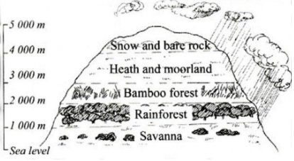 (1 X 5=5m)
- Define the term vegetation (2m)
- Describe four adaptations of succulent perennials of tropical desert vegetation. (4m)
- Plants are leafless and have fibrous stems due to low photosynthesis and slow growth
- Plants have shallow root systems to absorb water from the top soil
- Plants have spines to protect them from destruction by animals
- Some swell to cylindrical shape during short rainy periods to survive the long drought
- The plants outer surfaces are hard, waxy to protect water storage cells/thick cuticle (1 X 4=4m)
- Form four students carried out a field study on a tropical rain forest in a certain area in Africa.
- Name three hardwood tree species they are likely to observe. (3m)
- Sapele -Teak - Mahore
- Camphor - Ebony - Dahoma
- Okoume - Rosewood - Green heart
- Mahogany - Azobe - Guarea
- Iroko -Zebrano (1 X 3=3m)
- Formulate a hypothesis for their study. (2m)
- Most of the trees in the forest have canopies
- The trees are mainly exploited for fuel
- The main problem experienced in exploiting trees is inaccessibility (2 X 1=2m)
- State three methods of recording data that the students used in their field study. (3m)
- Taking photographs/video taping of trees
- Note taking form observation of vegetation done
- Tape recording of resource persons/local community
- Tallying of tree species counted
- Drawing/sketching of trees in the forest
- Mapping of the forest
- Name three hardwood tree species they are likely to observe. (3m)
-
-
- Define the term Oceans ( 2 mks)
- A vast body of salty water on the earth surface that surrounds the land or continent
- Name four features formed as a result of wave deposition ( 4 mks)
- Beaches
- Spits
- Mudflats
- Cuspate foreland
- Dune belts
- Bars
- Tombolo
- Salt-Marshes
- State five differences between oceans and seas ( 5 mks)
- Oceans are affected by tides while only marginal seas are affected by tides
- Oceans have strong ocean currents while only marginal seas are affected by ocean currents
- Oceans experience strong winds which cause hurricanes /tornadoes while only a few marginal seas experience strong winds which cause whirl winds called waterspouts.
- Sunlit eastern coasts of oceans lead to coral formation while in seas there is no coral formation.
- Oceans surround continents or vast lands while seas are surrounded by land / marginal seas bound continents.
- Describe the formation of a cave ( 4 mks)
- It mainly forms at the base of a cliff;
- Abrasion and hydraulic force enlarge initial hollow/line of weakness in the coastal rock;
- Corrosion at the base of cliff enlarges the hollow which extends inward into the cliff;
- The process continues until the hollow is transformed into a cylindrical chamber called a cave;
- Identify and name the features marked P, Q, & R ( 3 mks)
- P- headland
- Q-Spit
- R-Stack
- Give three main types of submerged upland coasts ( 3 mks)
- Rias
- Fjords/fiords
- Dalmatian coasts
- Explain two negative significance of coasts and coastal features ( 4 mks)
- Coasts that have emerged recently generally have poor sandy soils which are unsuitable for growing variety of crops.
- Sand and formation of corals inhibits water transport and development of ports / tankers which hit coral reefs causes oil spills.
- Define the term Oceans ( 2 mks)
Join our whatsapp group for latest updates
Tap Here to Download for 50/-
Get on WhatsApp for 50/-
Download Geography Paper 1 Questions and Answers - Sukellemo Joint Pre Mock Exams 2023.
Tap Here to Download for 50/-
Get on WhatsApp for 50/-
Why download?
- ✔ To read offline at any time.
- ✔ To Print at your convenience
- ✔ Share Easily with Friends / Students