
INSTRUCTION TO STUDENTS.
- This paper has two sections A and B.
- Answer ALL the questions in section A.
- Answer question 6 and any other TWO questions from section B. .
- Candidates should answer the questions in English.
SECTION A: 25 MARKS
Answer ALL questions in this section.
-
- What is physical Geography? (2marks)
- Give three divisions of physical Geography. (2marks)
- State four effects of rotation of the earth (4marks)
- The diagram below represents zones of natural vegetation on a mountain. Use it to answer questions that follow
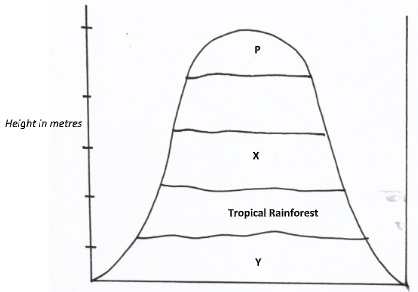
- Identify the vegetation zones marked X and Y. (2marks)
- State four characteristics of tropical rainforest vegetation. (4marks)
-
- Identify two erosional processes in a desert landscape. (2marks)
- Describe the formation of a mushroom block (3marks)
-
- Define a lake (2marks)
- Give three reasons why some rift valley lakes are fresh water. (3marks)
SECTION B
Answer question 6 and any other two question in this section
-
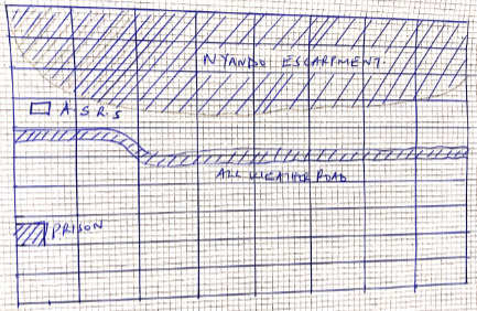
- Study the map of Kisumu East 1:50,000 (sheet 116/2) provided and answer the following questions.
- What type of map is Kisumu East map extract? (1mark)
- Give two scales that have been used in the map extract. (2marks)
- What is the bearing of the trigonometrical station at grid square 0383 from the Air Photo Principal Point at grid square 0281? (2marks)
-
- Measure the length of the All Weather Road Bound Surface B2/1 from the junction at Grid square 9793 to the western edge of the map extract. Give your answer in kilometer. (2marks)
- What is the altitude of the highest point in the area covered by the map? (2marks)
- Draw a rectangle measuring 16cm by 10cm to represent the area enclosed by Eastings 02 and 10 and Northing 90 and 00. (1mark)
On the rectangle, mark and name the following. (4marks)- Nyando escarpment.
- All Weather Road Bound Surface C543/1
- Prison
- Agricultural Sugar Research Station.
-
- Describe the drainage of the area covered by the map. (5marks)
- Citing evidence from the map, identify three social services offered in Kisumu Municipality. 6marks)
- Study the map of Kisumu East 1:50,000 (sheet 116/2) provided and answer the following questions.
-
- The diagram below shows the structure of the earth. Use it to answer the question that follows.
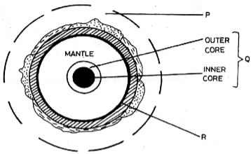
- Name the parts marked : (2marks)
- P
- Q
- Describe the composition of the crust (5marks)
- Name the parts marked : (2marks)
-
- Define the term solar system. (2marks)
- Using a well labelled diagram describe the occurrence of the solar eclipse. (5marks)
-
- What is climate change? (2marks)
- State four human activities which contribute to greenhouse effect. (4marks)
- Mention effects of global warming on human activities. (5marks)
- The diagram below shows the structure of the earth. Use it to answer the question that follows.
-
-
- What are earth movements? (2marks)
- State three causes of earth movements? (3marks)
-
- Define folding
- Describe how a recumbent fold is formed. (4marks)
-
- Apart from a recumbent fold, name two other types of folds. (2marks)
- Name four features resulting from folding apart from fold mountains. (4marks)
- Name two examples of fold mountains in Africa. (2mks)
- Explain four significance of folding to human activities. (8marks)
-
-
-
- Define the term hydrological cycle. (2marks)
- Give three processes of hydrological cycle. (3marks)
-
- State three factors that influence river erosion. (3marks)
- Describe the following river erosion processes.
- Abrasion (3marks)
- Solution. (3marks)
-
- Apart from arcuate delta, name two other types of coastal delta. (2marks)
- Explain three conditions necessary for delta formation. (6marks)
- State three factors which influence the formation of river drainage patterns. (3marks)
-
-
- Give two places in East Africa that are permanently covered by ice (2marks)
-
- Identify three ways in which glaciers move (3marks)
- Explain factors that influence the movement of ice. (4marks)
-
- Describe how the hanging valleys are formed (6marks)
- State three significance of lowland glacial features to human activities (3marks)
- Your class plans to carry out a field study on glaciation on the slopes of Mt. Kenya.
- What preparations will you make before the actual study (4 marks)
- Identify three methods that you will use to collect data during your study (3 marks)
MARKING SCHEME
SECTION A: 25 MARKS
Answer ALL questions in this section.
-
- What is physical Geography? (2marks)
- It is the branch of geography that deals with the formation of physical features/land forming processes.
- Name three divisions of physical Geography. (3marks)
- geomorphology
- spatial geography
- climatology
- oceanology
- pedology
- What is physical Geography? (2marks)
- State four effects of rotation of the earth. (4marks)
- Cause day and night
- Causes falling and rising of ocean tides.
- Causes deflection of winds and ocean currents.
- Causes variation in the speed of air masses.
- Causes differences in time between longitudes.
- Study the diagram showing vegetation zones of a mountain slope. Use it to answer questions [a] and [b]
- identify the vegetation zones marked X and Y (2marks)
- X – Bamboo vegetation
- Y – Savana grassland vegetation
- State four characteristics of tropical rainforest. (4marks)
- Most trees are hard woods
- Most trees are evergreen
- Most trees have broad leaves
- Trees are of mixed species
- Have thick under growth
- Trees are tall and form canopies
- identify the vegetation zones marked X and Y (2marks)
-
- Identify two erosional processes in a desert landscape. (2marks)
- Abrasion
- Deflation
- Describe the formation of a mushroom block. (3marks)
- Amass of rock with uniform rock resistance/ homogenous rock stands on a desert surface.
- Weathering and abrasion attacks the rock mass such that undercutting is more at the base and smoothening /polishing at the top forming a mushroom shaped block of rock having a narrow base and broad rounded top called Mushroom block.
- Identify two erosional processes in a desert landscape. (2marks)
-
- What is a lake? (2marks)
- An extensive mars of water body that has accumulated / collected in a depression / hollow on the earth’s surface.
- Give three reasons why some rift valley lakes are fresh water. (3marks)
- Some have surfaces outlets that carry away excess salts.
- Some are situated in high rainfall areas supplying fresh water.
- Some are located in high rainfall receiving low temperature reading evaporation.
- Some have regular inflow of fresh water.
- Some have underground / subterranean outlets draining away salts on the lake bed.
- What is a lake? (2marks)
SECTION B
Answer question 6 and any other two question in this section.
-
- Study the map of Kisumu East 1:50,000 (sheet 116/2) provided and answer the following questions.
- What type of map is Kisumu East map extract? (1mk)
- Topographical map.
- Give two scales that have been used in the map extract. (2mks)
- Linear scale.
- Representative scale.
- What is the bearing of the trigonometrical station at grid square 0383 from the Air Photo Principal Point at grid square 0281? (2mks)
- 053°/N53°E
- What type of map is Kisumu East map extract? (1mk)
-
- Measure the length of the All Weather Road Bound Surface B2/1 from the junction at Grid square 9793 to the western edge of the map extract. Give your answer in kilometer. (2mks)
4.9 ±1km - What is the altitude of the highest point in the area covered by the map? (2mks)
- 1872 meters above the sea level.
- Measure the length of the All Weather Road Bound Surface B2/1 from the junction at Grid square 9793 to the western edge of the map extract. Give your answer in kilometer. (2mks)
- Draw a rectangle measuring 15cm by 10cm to represent the area enclosed by Eastings 02 and 10 and Northing 90 and 00. (1mk)
On the rectangle, mark and name the following. (4mks)- Nyando escarpment.
- All Weather Road Bound Surface C543/1
- Prison
- Agricultural Sugar Research Station.
-
- Describe the drainage of the area covered by the map. (5mks)
- The main drainage features are rivers/lake/seasonal swamp.
- Most rivers are permanent
- Some rivers in the north eastern part are disappearing/vanishing.
- River Nyamasaria and its tributaries form dendritic drainage pattern.
- River Ombeyi flows from the East towards the West.
- Most rivers have meanders along their course.
- River Luando has a delta on its mouth.
- There are seasonal swamps and papyrus swamp in the area covered by the map.
- Some rivers originate from Nyando escarpment.
- Citing evidence from the map, identify three social services offered in Kisumu Municipality. (6mks)
- Health/medical service evidenced by hospitals/dispensary.
- Religious services evidenced by church/mission.
- Security services evidenced by police station.
- Housing evidenced by built up areas.
- Water supply evidenced by water pipes.
- Burial service evidenced by cemetery
- Recreational services evidenced by stadium
- Correctional/rehabilitation services evidenced by prison.
- Describe the drainage of the area covered by the map. (5mks)
- Study the map of Kisumu East 1:50,000 (sheet 116/2) provided and answer the following questions.
-
- The diagram below shows the structure of the earth. Use it to answer the question that follows.
- Name the parts marked : (2mks)
- P. Atmosphere.
- Q. Core.
- Describe the composition of the crust (5mks)
- Made of soils and other loose deposits of sand
- The dominant rocks are granites.
- Has 2 layers ie the continental layer and the oceanic layer.
- The continental crust is made up of light coloured rocks
- The dorminant mineral of the sial are silica and aluminium.
- The oceanic layer is mainly made of basaltic rocks which are brittle.
- The dorminant minerals of the oceanic layer are silica and magnesium.
- Name the parts marked : (2mks)
-
- Define the term solar system. (2mks)
- The composition of the sun, planets and other heavenly bodies orbiting around the sun.
- Using a well labelled diagram describe the occurrence of the solar eclipse. (5mks)
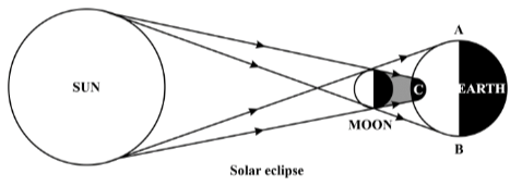
- The moon comes between the earth and the sun
- The moon’s shadow is cast on the earth
- The earth appears to be covered by darkness
- Define the term solar system. (2mks)
-
- What is climate change? (2mks)
- Is the establishment of a new climatic state or system in an area due to change in weather elements such as temperature and precipitation over time.
- State four human activities which contribute to greenhouse effect. (4mks)
- Burning of fossil fuels.
- Deforestation and land use changes.
- Agricultural activities
- Industrial developments.
- State effects of global warming on the environment. (5mks)
- Increased rainfall.
- Changes in natural ecosystem
- Flooding leading to rise in sea level
- Shifting of climatic and vegetation zones
- Abundant growth of plants.
- Occurrence of flash floods.
- Increased ultra-violet radiation that results in sunburn.
- What is climate change? (2mks)
- The diagram below shows the structure of the earth. Use it to answer the question that follows.
-
-
- what are earth movements? (2marks)
- These are movements of the rocks of the crust caused by tectonic force in the interior of the earth.
- State three causes of earth movements. (3marks)
- Magma movements within the earth’s crust.
- Convectional currents in the mantle
- Isolation adjustments of the earth’s crust.
- Gravitative pressure/force of gravity.
- what are earth movements? (2marks)
-
- Define folding (2marks)
- The bending of crustal rocks due to compressional forces.
- Describe how a recumbent fold is formed (4marks)
- The crustal rocks are subjected to strong compressional forces on one side leading to formation of a symmetrical fold.
- The strong compressional forces confines to push over folds on one side of asymmetrical fold such that the outline gets pushed over the limb of the next fold forming over-fold.
- Continued compressional force causes the over fold to be puddled over completely such that they lie in horizontal position forming a recumbent fold.
- Define folding (2marks)
-
- Apart from a recumbent fold, name two other types of folds. (2marks)
- Simple/symmetrical fold
- Asymmetrical fold
- Overfold
- Overthrust fold
- Isoclinal fold
- Anticlinorium-synclinorium complex
- Name four features resulting from folding apart from fold mountains. (4marks)
- Synclinal valleys/depressions
- Rolling plains
- Ridge and valley landscape
- Inter-montane plateau
- Inter-montane basin
- Escarpments
- Name two examples of Fold Mountains in Africa. (2mks)
- Atlas
- Cape Ranges
- Akwapin Hills.
- Apart from a recumbent fold, name two other types of folds. (2marks)
- Explain four significant of Fold Mountains to human activities. (8marks)
- Fold mountains forms windward slopes receiving high rainfall supporting agricultural activities / farming forestry / human settlement.
- Fold Mountains with lee ward slope are suitable for establishment of game parks / game reserve/passion since E receives low unreliable rainfall.
- Windward slopes receive high rainfall for the development of rivers supplying water for domestic / irrigation.
- Fold Mountains are tall and may be snowcapped forming beautiful scenery that attracts tourist promoting tourism.
- Some fold mountains may contained valuable minerals due to rock metamorphism enhancing mining.
-
-
-
- Define the term hydrological cycle. (2mks)
- Hydrological cycle is the continuous movement of water from the air to the earth surface and back to the air.
- Give three processes of hydrological cycle. (3mks)
- Evaporation/evapotranspiration/moist air rising.
- Condensation/moist air cooling.
- Percolation/infiltration.
- Surface run-off/overland flow.
- Precipitation/rainfall/snow fall.
- Define the term hydrological cycle. (2mks)
-
- State three factors that influence river erosion. (3mks)
- The volume of the river.
- The gradient of the river channel.
- The nature of the river load.
- The nature of the rock.
- Describe the following river erosion processes.
- Abrasion (3mks)
- The load carried by a river is used to erode a river channel.
- The river uses the load (sand/pebbles/silt) to scrub/rub/scratch/grind and polish its bed and banks.
- It leads to deepening and widening of the river channel.
- Solution. (3mks)
- Occurs on rocks of river channels which contain soluble minerals.
- The flowing river water comes across rocks which contain soluble minerals.
- The soluble minerals are dissolved in the river water and carried downstream within the water currents.
- Abrasion (3mks)
- State three factors that influence river erosion. (3mks)
-
- Apart from arcuate delta, name two other types of coastal delta. (2mks)
- Birds foot delta.
- Estuarine delta.
- Explain three conditions necessary for delta formation. (6mks)
- There must be large quantities of silt or sediments ro be deposited at the river mouth.
- There should be low velocity of the river at the river mouth.
- There should be a shallow continental shelf or shore around the river mouth.
- High rate of deposition than rate of removal silt at the river mouth/presence of calm sea/weak sea waves/weak tidal currents at the coast.
- Absence of obstacles/filters in the river course.
- Apart from arcuate delta, name two other types of coastal delta. (2mks)
- State three factors which influence the formation of river drainage. (3mks)
- The angle of the slope of the land.
- The difference in rock resistance.
- The arrangements of the rock layers/rock structure.
- Faulting of rocks of thereaths crust.
-
-
- Give two places in East Africa that are permanently covered by ice (2mks)
- Peak of Mt. Kenya
- Peak of Mt. Ruwenzori
- Peak of Mt. Kilimanjaro
-
- Identify three ways in which glaciers move (3mks)
- Plastic Flowage
- Basal Slip
- Extrusion Flow
- Internal Shearing
- Explain factors that influence the movement of ice from a place where it has accumulated (4mks)
- Gradient of the Land-Ice moves faster on steep slopes than on gentle slopes due to the influence of gravity i.e. greater gravity on steep slopes and thus high speed.
- Season- Ice movement is faster in summer due to frequent thawing and melting compared to winter when thawing is rare
- Friction-Central parts of ice move faster than sides and bottom which are in contact with rock beneath and thus face resistance due to friction.
- Thickness of Ice- Thicker masses of ice cause more pressure between them and rocks beneath which cause slight melting and therefore faster movement. Thicker ice moves fast while thin ice moves slowly.
- Identify three ways in which glaciers move (3mks)
-
- Describe how the hanging valleys are formed (5mks)
- Ice occupies pre-existing main valley and tributary valley
- The main valley and tributary valley are eroded by glaciers through abrasion and plucking
- More erosion is experienced on the main valley than the tributary valley due to more glaciers.
- The main valley is deepened and widened through vertical and lateral erosion forming glacial trough
- The eroded tributary valley remains suspended on the upper edge of the main valley and is called the hanging valley
- State significances of lowland glacial features to human activities (4 marks)
- Some outwash plains have fertile morainic soils suitable for agriculture e.g. Canadian prairies where wheat is grown.
- Glacial lakes such as great lakes of North America provide natural route ways and fish sources thus influencing fishing and transport.
- Sheltered water of fiords is a suitable breeding ground of fish therefore encouraging fishing.
- Sand excavated from outwash plains and eskers is used for construction enhancing the construction industry.
- Describe how the hanging valleys are formed (5mks)
- Your class plans to carry out a field study on glaciation on the slopes of Mt. Kenya.
- What preparations will you make before the actual study (4 marks)
- Assembling necessary tools
- Drawing work schedule
- Drawing route maps
- Dividing into groups
- Reading more on the topic
- Seeking permission
- Identify three methods that you will use to collect data during your study. (3 marks)
- Observing
- Administering questionnaires
- Interviewing
- Reading through relevant books / content analysis
- Taking photographs
- What preparations will you make before the actual study (4 marks)
- Give two places in East Africa that are permanently covered by ice (2mks)
Join our whatsapp group for latest updates
Tap Here to Download for 50/-
Get on WhatsApp for 50/-
Download Geography Paper 1 Questions and Answers - Mokasa Pre Mock Exams 2023.
Tap Here to Download for 50/-
Get on WhatsApp for 50/-
Why download?
- ✔ To read offline at any time.
- ✔ To Print at your convenience
- ✔ Share Easily with Friends / Students