
INSTRUCTIONS TO CANDIDATES
- This paper has two sections: A and B.
- Answer all the questions in section A.
- Answer question 6 and any other two questions from section B.
SECTION A
Answer all questions in this section
-
- What is the relationship between Geography and Physics. (2 marks)
- Name three main layers of the atmosphere from the earth’s surface upwards. (3 marks)
- The diagram below shows a barchan.
- Name the feature marked N. (1 mark)
- Name the air currents marked P. (1 mark)
- Give three reasons why wind erosion is dominant in hot deserts (3 marks)
-
- Differentiate between vulcanicity and volcanicity? (2 marks)
- State three effects of vulcanicity on agriculture (3 marks)
-
- State three causes of earth movements (3 marks)
- Name two main earthquake zones in world (2 marks)
-
- Define the term oceans (2 marks)
- State three reasons why ocean waters are salty (3 marks)
SECTION B
Answer question 6 and any other two questions from this section
- Study the map of Kisumu East 1: 50,000 (Sheet 116/2) provided to answer questions that follow.
-
- Give the sheet title. (2 marks)
- Give the longitudinal extent of the area covered by the map. (2 marks)
- Measure the length of the all-weather road bound surface 1321, from the junction at grid reference 974911 to the western edge of the map. Give your answer in kilometres. (2 marks)
-
- Calculate the area of Kisumu Town. Give your answer in km². (2 marks)
- Name three human made features in the grid reference 0383 (3 marks)
- Describe the drainage of the area covered by the map. (5 marks)
-
- Using a vertical scale of 1cm represents 20 metres, draw a cross section between Eastings 95 and 01 along Northing 98. (4 marks)
On the cross section, mark and label:- Regional boundary (1 mark)
- River (1 mark)
- Road (1 mark)
- Calculate the vertical exaggeration, (V.E) of the cross section. (2 marks)
- Using a vertical scale of 1cm represents 20 metres, draw a cross section between Eastings 95 and 01 along Northing 98. (4 marks)
-
-
-
- Apart from simple fold, name three other types of fold. (3 marks)
- Identify two characteristics of simple fold. (2 marks)
- Give two factors that influence the magnitude of folding (2 marks)
- Mention three fold-mountain forming periods. (3 marks)
-
- Using a well-labelled diagram, describe the formation of a fold mountain. (7 marks)
- State three significance of fold mountain to man (3 marks)
- Suppose you carried out study in an area affected by folding.
- List three methods you used to collect data. (3 marks)
- Give two reasons why you could conduct a pre-visit. (2 marks)
-
-
-
- What is soil catena? (2 marks)
- Give three components of soil. (3 marks)
-
- List characteristics of desert soils. (3 marks)
- Give two factors that contribute to soil leaching (2 marks)
-
- state two economic uses of soils. (2 marks)
- Explain how the following farming practices may lead to loss of soil fertility:
- Overgrazing (2 marks)
- Frequent ploughing (2 marks)
- Continuous irrigation (2 marks)
- You are supposed to carry out a field study of an eroded area.
- What information would you collect through observation that would indicate that the area is severely eroded? (3 marks)
- State four recommendations you would give to control soil erosion. (4 marks)
-
-
-
- List any three sources of underground water (3marks)
- Differentiate pervious rocks from porous rocks (2marks)
- Explain four factors that influence the occurrence of underground water. (8marks)
-
- Mention any three factors necessary for the formation of karst features. (3marks)
- List any three underground features of karst areas (3marks)
- Explain any three significance of karst features to man. (6marks)
-
-
- What is river capture? (2 marks)
-
- List three types of meanders at a lower course of a river. (3 marks)
- State three factors influencing the rate of erosion. (3 marks)
-
- Give three processes of river erosion (3 marks)
- Describe four processes through which a river transports its load (8 marks)
- Explain three negative influences of rivers on human activities (6 marks)
MARKING SCHEME
SECTION A
Answer all questions in this section
-
- What is the relationship between Geography and Physics?
- Physics deal with matter, energy, light, heat, sound, gravity and magnetism while studying the atmosphere;
- Geography focuses on heat from the sun as it’s responsible for movement of air, vaporation of water and distribution of moisture in the atmosphere.
- Physics is a branch of Science concerned with study of matter and its properties; Physics is important in Geography as it is used to explain how important process such as faulting, folding, weather and vulcanicity happen. (1 x 2 = 2 marks)
- Name three main layers of the atmosphere from the earth’s surface upwards.
- Troposphere
- Stratosphere
- Mesosphere
- Thermosphere/ionosphere (any 3 x 1 = 3 marks)
- What is the relationship between Geography and Physics?
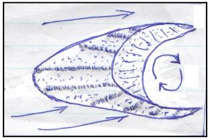
- The diagram below shows a barchan
- Name the feature marked N
- N- horn (1 mark)
- Name the air currents marked P.
- Wind eddies /eddying winds (1 mark)
- Give reasons why wind erosion is dominant in hot deserts
- The area is devoid of vegetation
- The unconsolidated nature of the materials
- Absence of moistures
- Presence of strong tropical winds within the hot deserts (3 x 1 = 3marks)
- Name the feature marked N
-
- Differentiate between vulcanicity and volcanicity
- Vulcanicity is the process through which igneous materials are intruded into the earth’s crust while volcanicity is the process through which igneous materials are extruded onto the earth’s surface. 2 marks (double tick)
- State three effects of vulcanicity on agriculture
- Some weathered volcanic materials form fertile soils which encourage agriculture
- Some weathered volcanic soils/freshly erupted lava produce infertile soils which discourages agriculture
- Windward side of volcanic mountains receives high rainfall which encourages agriculture
- Leeward side of volcanic mountains receives low rainfall which discourages agriculture (Any 3x1=3 marks)
- Differentiate between vulcanicity and volcanicity
-
- State three causes of earth movements
- Isostatic adjustment
- Gravitational pressure
- Magma movement within the crust
- Convectional currents in the mantle (Any 3x1 = 3 marks)
- Name two main earthquake zones in word
- The curcum pacific belt
- The mid-Atlantic ridge
- Mediterranean – Himalayan belt
- Rift Valley (Any 2x1=2 marks)
- State three causes of earth movements
-
- Define the term oceans
- Large and extensive body of saline water occupying a basin between continents (2 marks)
- State three reasons why ocean waters are salty
- Volcanic materials add salt to ocean water
- Mineral salts were present during formation of oceans
- Sea water dissolves salt water directly from rocks on the sea floor
- Rivers carry dissolved salt from land and deposit them in oceans (Any 3x1=3 marks)
SECTION B
Answer question 6 and any other two questions from this section
- Define the term oceans
- Study the map of Kisumu East 1: 50,000(Sheet 116/2) provided to answer questions that follow.
-
- Give the sheet title.
- EAST AFRICA 1:50,000(KENYA) (2 marks)
- Give the longitudinal extent of the area covered by the map.
- 34˚45̍ E -35˚00ˈE (2 marks )
- Measure the length of the all-weather road bound surface from the junction at grid reference 974911 to the western edge of the map. Give your answer in kilometres.
- 7.2km ±0.1(7.1km,7.2km,7.3km) (2 marks)
- Give the sheet title.
-
- Calculate the area of Kisumu Town. Give your answer in km²
- Complete squares = 5
- Incomplete squares = 16
- Area = 5+ 16/2
= 13.0km² ±0.5(12.5 km².13.0 km13.5 km²) ( 2 marks)
- Name three human made features in the grid reference 0383
- Health centre
- Market
- Road
- Chief’s office
- Houses/villages
- Foot path (Any 3x1=3 marks)
- Calculate the area of Kisumu Town. Give your answer in km²
- Describe the drainage of the area covered by the map.
- The main drainage feature is rivers.
- Most rivers are permanent.
- The main rivers in the area are Ombeyi,Luando,Nymasaria
- Most rivers flows southwards
- There are seasonal swamps to the southern part of the area covered by the map
- There is a lake to the south western part of the area covered by the map
- Some rivers form dendritic drainage pattern
- There are papyrus swamps on the area covered by the map (Any 5x1=5 marks)
-
- Using a vertical scale of 1cm represents 20 metres, draw a cross section between Eastings 95 and 01 along Northing 98.
On the cross section, mark and label:- Regional boundary
- River
- Road
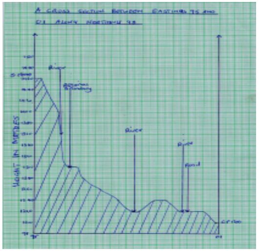
- Title= 1 mark
- labeled y-axis= 1 mark
- Starting (1460m) = ½ mark
- end points (1200m) = ½ mark
- Trend= 1 mark
- River = 1 mark
- Road= 1 mark
- Boundary= 1 mark (total= 7 mark)
- Calculate the vertical exaggeration (V.E) of the cross section.
- V.E =VS/HS
- V.E=1:2,000/1:50,000 = 25 times (2 marks)
- Using a vertical scale of 1cm represents 20 metres, draw a cross section between Eastings 95 and 01 along Northing 98.
-
-
-
- Apart from simple fold, name other three types of fold.
- Asymmetrical fold
- Isoclinal fold
- Recumbent fold
- Nappe/over thrust fold
- Anticlinorium fold
- synclinorium fold (Any 3x1=3 marks)
- Identify two characteristics of simple fold.
- The rocks bend evenly
- The limbs dip uniformly/evenly in opposite direction
- The anticline shows a degree of symmetry about the axis /the axis is perpendicularly to the anticline
- Formed due to compressional forces of equal magnitude
- Formed due to mild compressional forces (Any 2x1=2 marks)
- Give two factors that influence the magnitude of folding
- Amount of force involved
- Amount of rock materials
- Nature of rock material (Any 2x1=2 marks)
- Apart from simple fold, name other three types of fold.
-
- Mention three fold-mountain forming periods.
- Charnian orogeny
- Caledonian orogeny
- Alpine orogeny
- Hercynian orogeny (Any 3x1=3 marks)
- Mention three fold-mountain forming periods.
-
- Using a well-labelled diagram, describe the formation of a fold mountain.
- An extrusive depression called geosyncline is formed on the earth surface
- It became filled with water forming a sea
- The surrounding land masses is eroded and the sediments are deposited in the geosynclines in layers
- Their weight cause the geosynclines to subside even further
- These sediments are subjected to compression force triggered by conventional currents in the mantle
- The layers in the sediments in the geosynclines are then folded /bent upward to form Fold Mountains
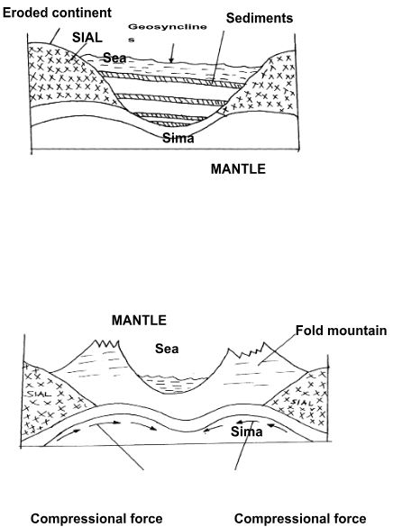
(Description=4 marks,diagram( geosycline,sendments and fold mountain-1 mark each =3 marks)
- State three significance of fold mountain to man
- Heavy rainfall on windward side supports luxuriant growth of forest which are a source of valuable timber for making furniture ,building and construction
- The heavy rainfall received on fold mountains together with snow that collects on some of them give rise to rivers which in turn provide water for irrigation and generation of H.E.P
- Cold winds descends to the low land and valley causing a lot of harm to crops
- Fold mountains could bring valuable mineral to the surface making their exploitation /mining easy
- Fold mountains areas discourages settlement due to ruggedness
- Fold Mountains are a barrier to transport and communication (Any 3x1=3 marks)
- Using a well-labelled diagram, describe the formation of a fold mountain.
- Suppose you carried out a field study in an area affected by folding.
- List three methods you used to collect data.
- Oral interview
- Direct observation
- Administering questionnaires
- Taking measurements
- Taking Photography
- Collecting Samples (Any 3x1=3marks)
- State two reasons why they could conduct a pre-visit.
- Helps to estimate the distance
- Helps in sampling of the area thus saving time
- Helps to estimate the cost of travel
- Helps to familiarizing with the area authority
- Helps to assemble necessary tools
- Helps decide on the methods of data collection to be used (Any 2x1=2marks)
- List three methods you used to collect data.
-
-
-
- What is soil catena?
- Soil catena refers to the sequence of different soils down a slope (2 marks)
- Give three components of soil.
- Soil water
- Soil mineral matter/inorganic matter
- Soil air
- Soil living organisms/micro-organisms
- Soil organic matter (Any 3x1=3 marks)
- What is soil catena?
-
- List three characteristics of desert soils.
- They are thin/shallow
- They have limited humus/low organic content
- They are saline
- They are coarse textured/loose grained
- They are porous/have large pores
- Are light coloured
- Have poorly developed profile
- Have limited /low moisture (Any 3x1=3 marks)
- Give two factors that contribute to soil leaching
- Presence of high rainfall/alternative wet and dry seasons
- Presence of fairly leveled ground/gentle slopes
- Presence of Soluble soil minerals/inorganic matter (Any 2x1=2marks)
- List three characteristics of desert soils.
-
- State two economic uses of soils.
- Some soils are sources of valuable minerals
- Some soils eg clay soils are raw materials for pottery/ceramics/making tiles/bricks
- Some soils are used in building/construction industry
- Soils rich in nutrients promote agriculture
- Some soils are mixed with herbs and sold for medicinal purposes e.g clay/
- Some soils are eaten directly as food (Any 2x1=2marks)
- Explain how the following farming practices may lead to loss of soil fertility:
- Overgrazing
- Overgrazing leads to removal of vegetation cover thereby exposing soils to various agents of erosion (2 marks)
- Frequent ploughing
- It weakens the soil structure making it easy to be carried away by various erosion agents
- Increases oxidation which results in loss of organic matter (2 marks)
- Continuous irrigation
- Cause leaching of the soil nutrients making the top soil deficient of soluble minerals. (2 marks)
- Overgrazing
- State two economic uses of soils.
- You are supposed to carry out a field study of an eroded area.
- What information would you collect through observation that would indicate that the area is severely eroded?
- Presences of gullies/deep trenches
- Absences of/limited vegetation
- Little/absence of top soils/thin soils
- Exposed plant roots (Any 3x1=3 marks)
- State four recommendations you would give to control soil erosion.
- Afforestation/reafforestation
- Construction of gabions
- Filling in the gullies
- Construction of check dams.
- Practicing appropriate methods of farming/planting cover crops/mulching/terracing/contour ploughing/strip cropping/crop rotation
- Construction of drainage trenches (Any 4x1=4 marks)
- What information would you collect through observation that would indicate that the area is severely eroded?
-
-
-
- List any three sources of underground water
- Rainwater
- Meltwater
- Lake and sea water
- Magmatic water (Any 3x1=3 marks)
- Differentiate pervious rocks from porous rocks
- Pervious rocks are rocks that allow water to pass through them through their cracks /joint/ fissures while porous ones allow water to pass through them via their spaces/pores. (2 marks, double tick)
- List any three sources of underground water
- Explain four factors that influence the occurrence of underground water.
- Precipitation and evaporation rate - Areas receiving high precipitation and low rate of evaporation, there will be high rate of percolation underground
- The nature of the slope of an area - Water percolation is greater on gentle slopes
- Steep slopes experience very little percolation - Nature of the rocks - Porous and pervious rocks are permeable thus allow water to pass through them to underground.
- Amount of vegetation cover in an area - Areas with a lot of vegetation cover, percolation of water underground is higher because water is held for a longer time.
- Level of saturation of the ground - The drier the ground the higher rate of infiltration. (Factor = 4 marks, explanation=4 marks) Nb factor can score without explanation but vice versa cannot score
-
- Mention any three factors necessary for the formation of karst features.
- Occurrence of thick limestone, chalk or dolomite rock
- Rocks must be hard and well jointed
- Presence of hot and humid climate
- Water table should be deep below the ground (Any 3x1=3 marks)
- List any three underground features of karst areas
- Stalactites
- Stalagmites
- Limestone pillars
- Underground caves
- Underground rivers (Any 3x1=3 marks)
- Mention any three factors necessary for the formation of karst features.
- Explain any three significance of karst features to man.
- Features like stalagmites, stalactites poljes attract tourist improving tourism industry.
- The lime stone block can be used in building houses.
- Limestone rocks are also used as raw materials in the cement making industries.
- The limestone grounds are dry and therefore provide good grounds for rearing of sheep.
- Underground caves are used as a storage of grains
- Roads /railways can connect countries/regions through underground caves (Any 3x2 = 6marks)
-
-
- What is river capture
- River capture is the diversion of the head waters of the weak river into the system of the adjacent powerful river (2marks)
-
- List three types of meanders at a lower course of a river
- Incised meanders
- Ingrown meanders
- Intrenched meanders (3 x 1 = 3marks)
- State three factors influencing the rate of erosion
- Gradient and velocity
- Volume of water
- Nature of bedrock
- Nature and amount of load ( Any 3 x 1 = 3 marks)
- List three types of meanders at a lower course of a river
-
- Give three processes of river erosion
- Solution /corrosion
- Corrasion
- Attrition
- Hydraulic action (Any 3 x 1 = 3marks)
- Describe four processes through which a river transports its load
- Suspension – light and insoluble materials are transported downstream in form of mixture/ They float on the surface of water
- Saltation – large materials are moved by water in a series of hops and jumps
- Traction – heavy materials like boulders are pushed and rolled along the bed by hydraulic action (force of gravity)
- Solution – the load is dissolved in water and transported downstream (Process= 4, description=4)
- Give three processes of river erosion
- Explaining three negative influences of rivers on human activities
- When river floods properties and human life are lost
- Water borne diseases – river water can be a medium of spreading diseases e.g. bilharzias, malaria
- Habitat of dangerous animals’ e.g. crocodiles, hippos, which kill people and livestock
- Wide rivers valleys are barriers to transport and communication among communities living on both sides of the rivers
(Any 3 x 2 = 6marks)
- What is river capture
Join our whatsapp group for latest updates
Tap Here to Download for 50/-
Get on WhatsApp for 50/-
Download Geography Paper 1 Questions and Answers - Lainaku 1 Joint PreMock Exams 2023.
Tap Here to Download for 50/-
Get on WhatsApp for 50/-
Why download?
- ✔ To read offline at any time.
- ✔ To Print at your convenience
- ✔ Share Easily with Friends / Students