
Questions
-
- Name two branches of Geography. (2mks)
- What is the relationship between Geography and Mathematics? (2mks)
- The diagram below represents the internal structure of the earth. Use it to answer question (a)
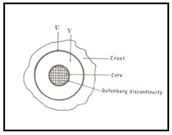
- Name the parts marked U and V. (2mks)
- Describe the composition of the
- Crust. (4mks)
- Core. (4mks)
-
-
- Describe the solar system. (2mks)
- The local time at manual 600W is 11.30am. What is the time in Nairobi 370E. (3mks)
- Give five proofs that the earth is spherical. (5mks)
- State two effects of the rotation of the earth. (2mks)
-
-
-
- Define the term weather. (2mks)
- Explain how the following factors influence weather
- Cloud cover. (4mks)
- Local winds. (4mks)
- The diagram below represents a weather measuring instrument. Use it to answer question (i) and (ii)
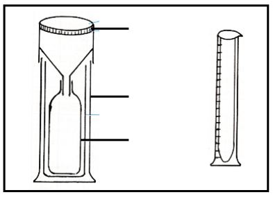
- Which element of weather is measured using the instrument shown above? (1mk)
- Describe how the instrument is used. (3mks)
- The table below shows the temperature and rainfall readings for station T in one week. Use it to answer question (c)
Day Mon Tue Wed Thur Fri Sat Sun Temperature °C 23 23 24 21 25 25 23 Rainfall in mm 50 49 49 45 60 60 49
-
- Calculate:
- The range of temperature for the week. (1mk)
- The mean weekly rainfall. (2mks)
- State four benefits of weather forecasting. (4mks)
- Calculate:
- Give four characteristics of the stratosphere. (4mks)
-
- Suppose your class carried out a field study on weather around your school environment;
- Give four methods the class used to collect data in the field. (4mks)
- State three advantages of studying weather through fieldwork. (3mks)
- State three problems likely to be encountered during fieldwork. (3mks)
-
- Give three types of maps. (3mks)
- State any two uses of maps. (2mks)
-
- Name two types of scales. (2mks)
- Give the uses of scales in a map. (2mks)
Marking Scheme
-
- Name two branches of Geography. (2mks)
- Physical Geography
- Human Geography
- What is the relationship between Geography and Mathematics? (2mks)
- Geography information can be analyzed or presented accurately through application of Mathematical techniques
- Name two branches of Geography. (2mks)
- The diagram below represents the internal structure of the earth. Use it to answer question (a)
- Name the parts marked U and V. (2mks)
- U – Mohorovicic discontinuity (moho)
- V – Mantle /Asthenosphere
- Describe the composition of the
- Crust. (4mks)
- Divided into two layers ie sime and Sisal
- Made of solid rocks
- Sial is rich in silica and Aluminium
- Sima is rich silica and Magnesium.
- Sima is made up of dense rocks 2.8 – 3.0gm/cc
- Sial is made of lighter rocks 2.7gm/cc it floats on Sima.
- Core. (4mks)
- Composed of two parts (inner core and Outer core)
- Outer ore has a density of 10 - 12gm/cc
- Temperature of the outer core is 37000C
- Inner core has a temperature of 55000C
- Both the inner and the outer core have iron and Nickel Minerals.
- Outer core is in molten state.
- The inner core exists in a solid state.
- Inner core has higher density of 16 -17gm/cc
- Crust. (4mks)
- Name the parts marked U and V. (2mks)
-
-
- Describe composition of the solar system. (2mks)
- The sun is the only star in the solar system. Several planets revolve round the sun.
- Smaller heavenly bodies include: natural satellite, meteoroids, asteroids and comets.
- The local time at Manaus 600W is 11.30am. What is the time in Nairobi 370E. (3mks)
- Answer 5:58 P.M
- Describe composition of the solar system. (2mks)
- Give five proofs that the earth is spherical. (5mks)
- Lunar eclipse
- Circular horizons
- Photograph taken by satellites
- Resemblance to other planets
- The approach of a ship in the port
- State two effects of the rotation of the earth. (2mks)
- Day and Night
- Deflection of winds
- Rising and falling of ocean tides
- Variation in speed of air masses
- Difference of one hour between meridians 150 apart
-
-
-
- Define the term weather. (2mks)
- Condition of the atmosphere of a given place over a short period of time
- Explain how the following factors influence weather
- Cloud cover. (4mks)
- Reduce the amount of solar radiation reaching the earth’s surface.
- Heavy cloud cover moderate both day and night temperature
- Absent of Clouds results in high day temperature and very low temperature.
- Local winds. (4mks)
- Land and sea breezes verse direction of prevailing winds
- Sea breeze also lower the temperatures of the surrounding areas
- Sea breeze may also increase precipitation by supplying extra moisture content through evaporation.
- Cloud cover. (4mks)
- Define the term weather. (2mks)
- The diagram below represents a weather measuring instrument. Use it to answer question (i) and (ii)
DIAGRAM- Which element of weather is measured using the instrument shown above? (1mk)
- Rain gauge
- Describe how the instrument is used. (3mks)
- Erected outside in open ground
- Water collects into the collecting jar though the funnel
- At time of taking measurements the funnel is removed from the barrel
- Water is poured into the measuring Cylinder
- A reading in millimetres is taken and recorded
- Which element of weather is measured using the instrument shown above? (1mk)
- The table below shows the temperature and rainfall readings for station T in one week. Use it to answer question
-
- Calculate:
The range of temperature for the week. (1mk)- Maximum – Minimum
25 -21 =0C
- Maximum – Minimum
- The mean weekly rainfall. (2mks)
50 + 49 + 55+ 45 + 60 + 60 + 49 = 368
7 7
= 52.57mm
- Calculate:
- State four benefits of weather forecasting to people. (6 marks)
- It enables farmers to plan their farming activities.
- It helps people to choose the clothing for the day.
- It influences design of houses.
- It guides in the timing of sporting / tourist activities.
- It helps in averting natural disasters related to weather.
- It guides in landing and taking off of aircrafts.
- It helps in planning military activities.
- It guides fishing activities
- Give four characteristics of the stratosphere. (4mks)
- Increase in temperature with increase in height has the ozone which absorbs UV light contains very little dust and water vapour. Atmospheric pressure containers to fall with increase in height
-
-
- Suppose your class carried out a field study on weather around your school environment;
- Give four methods the class used to collect data in the field. (4mks)
- Taking measurements
- Observation
- Experimentation
- Extracting from secondary source
- State three advantages of studying weather through fieldwork. (3mks)
- First hand information
- Reliable data
- Data obtained is accurate
- Saves time
- Highlight problems likely to be encountered during fieldwork. (3mks)
- Dishonest respondents
- Environmental
- Constraints Sickness
- Failure in keeping time
- Give four methods the class used to collect data in the field. (4mks)
-
- Give three types of maps. (3mks)
- Atlas maps
- Topographial
- Sketch
- State any two uses of maps. (2mks)
- Weather trends indications
- Political boundaries
- Direction and Location of places
-
- Name two types of scales. (2mks)
- Statement Scale
- Linear scale
- Representative Fraction scale
- Give the uses of scales in a map. (2mks)
- Measuring Distance on maps
- Calculated on maps
- Name two types of scales. (2mks)
- Give three types of maps. (3mks)
Join our whatsapp group for latest updates
Tap Here to Download for 50/-
Get on WhatsApp for 50/-
Download Geography Questions and Answers - Form 1 End Term 2 Exams 2022.
Tap Here to Download for 50/-
Get on WhatsApp for 50/-
Why download?
- ✔ To read offline at any time.
- ✔ To Print at your convenience
- ✔ Share Easily with Friends / Students


