
QUESTIONS
Instructions:
Answer all the questions in the spaces provided
-
- State three types of plate tectonic boundaries. (3mks)
- Give two evidences of continental drift. (2mks)
- List four major plates in plate tectonic theory. (4mks)
- State three significance of folding to human activities. (3mks)
- What is the difference between folding and faulting? (2mks)
- With the aid of labeled diagram, explain how a dyke is formed. (5mks)
-
- Give a definition of earthquakes. (2mks)
- Differentiate between sesmic focus and epicentre. (2mks)
- State the significance of rocks and minerals. (2mks)
- You are to carry out a field study on weather around your school.
- Give three methods of data collection. (3mks)
- State two follow up activities for the field study. (2mks)
MARKING SCHEME
-
- State three types of plate tectonic boundaries. (3mks)
- Extension boundaries (constructive margins)
- Compressional boundaries (destruction margins)
- Transform faults (conservative margin)
- Give two evidences of continental drift. (2mks)
- The jig-saw fit of continental drift.
- Geological structure distribution of ancient glacial deposit, paleontological evidence, palemagnetic.
- List four major plates in plate tectonic theory. (4mks)
- The eurasion plate
- The Australia plate
- The austrictic plate
- The north America plate, the African plate
- The south America plate, the pacific plate
- State three types of plate tectonic boundaries. (3mks)
- State three significance of folding to human activities. (3mks)
- Leads to the formation of mountain which receive heavy rainfall give rise to rivers.
- The process creates areas of crustal weakness which may trigger off volcanicty.
- Folding is significance in the formation of some minerals and brings minerals to the surface.
- Fold mountain forms unique scenery for tourist attraction.
- What is the difference between folding and faulting? (2mks)
- Folding is the bending of rocks of earths crust due to the earth movement while faulting is the cracking or fracturing of the rocks of the earth’s crust
- With the aid of labeled diagram, explain how a dyke is formed. (5mks)
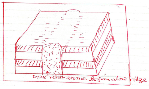
- Dyke is a mass of intrusive rock which is cuts across the bedding plane of existing rock.
- It can be vertical or inclined
- When the rock around is softer it will be eroded and will stand as a ridge.
- When dyke is softer than the surrounding rock it will be eroded to form along narrow depression.
- Give a definition of earthquakes. (2mks)
-
- Earthquake is the shaking or trembling of the rocks of the surface of the earth caused by shock waves that originating below the surface of the earth.
- Give the main difference between contours and form lines. (2mks)
- Contours are lines drains on a map to show all points with the same height above sea level. Form lines are lines drawn on a map which are not sufficiently mapped, form line are not accurately surveyed.
-
- State the significance of rocks and minerals. (2mks)
- Rocks form spectacular scene which act as tourist attraction.
- Certain type of rock act as water reservoirs and store a lot of water in the underground.
- Rocks provide the parent material for the formation of rich soil which are used for agriculture.
- You are required to carry out a field study on weather around your school.
- Give three methods of data collection. (3mks)
- Questionnaires
- Interviews
- Observation
- Experimentation
- Content analysis.
- State two follow up activities for the field study. (2mks)
- Writing a report.
- Analyzing and classifying the data collected.
- Conducting group discussion
- Giving a lecture to other students.
- Give three methods of data collection. (3mks)
Join our whatsapp group for latest updates
Tap Here to Download for 50/-
Get on WhatsApp for 50/-
Download Geography Questions and Answers - Form 2 Mid-term Exams Term 1 2022.
Tap Here to Download for 50/-
Get on WhatsApp for 50/-
Why download?
- ✔ To read offline at any time.
- ✔ To Print at your convenience
- ✔ Share Easily with Friends / Students


