
SECTION A
Answer all the question in this section
-
- What is nodamism? (2 mks)
- Nomadism is the traditional extensive livestock grazing on natural pasture with seasonal migration in search of water and pasture. 1*2= 2 mks
- State three characteristics of shifting cultivation. (3 mks)
- Involves clearing and slashing/burning
- The plots are small.
- There is little or no use of manure
- The plots are widely distributed.
- It involves subsistence farming.
- They rely on family labour. 3*1=3 mks
- What is nodamism? (2 mks)
-
- Name the areas where these minerals are mined in East Africa
- Diamond in Tanzania (1 mk)
- mwadui
- Phosphate in Uganda (1 mk)
- tororo
- Diamond in Tanzania (1 mk)
- Describe how solution mining method is carried out. (4 mks)
- Pipes are sunk into the ground to reach the mineral.
- Superheated water is pumped into the ground.
- The mineral is dissolved by the the superheated water.
- Pressure is created and the mineral is forced to rise to the surface.
- The mineral is collected and the water is evaporated to obtain the mineral.
NB:The sequence must be followed to score. 4*1=4 mks
- Name the areas where these minerals are mined in East Africa
-
- Define package tour (2 mks)
- This is a situation where the tour company receive a single fee to arrange for transport,accommodation,meals and entertainment in order for tourist to move in a group.
- State two problems facing tourists along the coastal regions of Kenya. (2 mks)
- There are attacks from terrorists/criminals on tourists and tourist facilities that leading to loss of life/property.
- The beach boys and are a nuisance to the tourists
- Increased pollution of beaches by the waste which is thrown along the beaches making them unattractive 2*1=2mks
- Define package tour (2 mks)
-
- Apart from noise pollution,name two other types of pollution. (2 mks)
- Air pollution
- Land pollution
- Land/soil/ground pollution
- Thermal pollution
- Radiation 2*1=2 mks
- State four effects of wind as an environmental hazard in Kenya. (2 mks)
- Strong winds destroy trees/crops
- Wind blows off roof of houses
- Wind causes soilerosion
- Winds spread air borne diseases
- Wind spread bush fires
- Wind causes strong sea storms and lead to boat capsizing/destruction of transport and communication lines 4*1=4 marks
- Apart from noise pollution,name two other types of pollution. (2 mks)
-
- Name two reclaimed regions of the Zuider-Zee in Netherlands. (2 mks)
- North Eastern polder
- Eastern Flevoland
- South Flevoland
- Markerwaad
- Wieringermeer 2*1=2 marks
- Give three benefits of the Delta Plan Project in Netherlands. (2 mks)
- Has helped to control pollution and salination of inland waters
- Has helped in the provision of fresh water from the reservoirs provided through the damming of Estuaries
- Floods have been controlled reducing destruction of life/property
- The dams/reservoirs are tourist attraction earning foreign exchange
- Has created more land used for settlement/agriculture
- Name two reclaimed regions of the Zuider-Zee in Netherlands. (2 mks)
SECTION B
Answer Question 6 and any other two questions from this question
- The table represent information on population of the Counties in Central Kenya according to the 2009 census report.Use it to answer question a.
COUNTIES
TOTAL POPULATION
Nyeri
693,558
Kirinyaga
528,054
Muranga
942,581
Kiambu
1,623,282
Nyandarua
596,268
TOTAL
4,383,743
-
- While using a radius of 4 centimetres,draw a simple pie-chart to represent the above information.
CalculationsNyeri
693,5588 *360°=56.97°=57°
4,383,743Kirinyaga
528,054 *360°=43.36°=43°
4,383,743
Muranga
942,581 *360°=77.49°=77°
4,383,743
Kiambu
1,623,282 *360°=133.1°=133°
4,383,743
Nyandarua
596,268*360°=48.97°=49°
4,383,743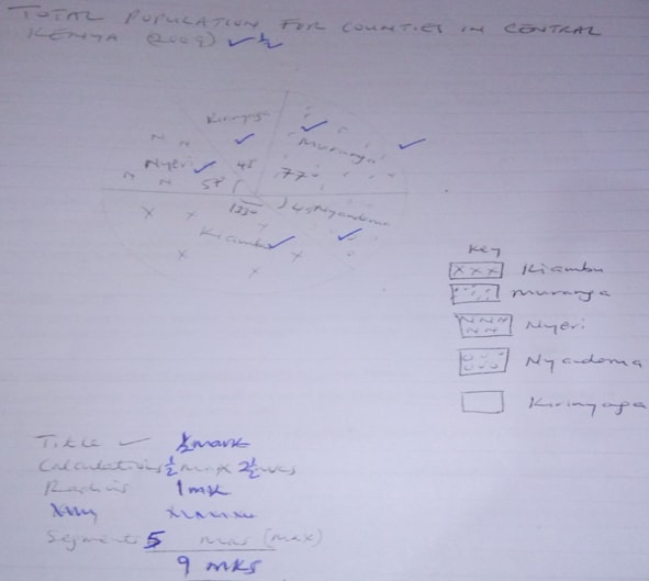
- Apart from using a simple pie-chart,list two statistical methods that can be used to represent the data
- Simple bar graph
- Divided Rectangle
- While using a radius of 4 centimetres,draw a simple pie-chart to represent the above information.
- State four reasons why the North Eastern part of Kenya has sparse population.
- The area receives low/unreliable rainfall to support agriculture
- Most parts have very thin/sandy/underground soils suitable for agriculture
- There is inadequate supply of surface water for domestic use to support settlement
- Some areas are insecure hence are avoided for settlement
- The area experiences extreme/high temperatures.26°c-32°c unsuitable for settlement
- Compare the population in Kenya and that of Sweden under the following:
- Dependency ratio. (2 mks)
- The dependency ratio in Sweden is very low leading to high savings while in Kenya the dependency ratio is high leading to low savings 1*2=2 marks
- Life expectancy (2 mks)
- The life expectancy in Sweden is high leading to high population of the aged while life expectancy in Kenya leading to low population of the elderly
- Dependency ratio. (2 mks)
- Explain three consequences of population growth to Kenya. (6 mks)
- Increased population resulting into development of slums/cheap housing facilities especially in urban centres leading to shortage of good houses
- Increased population leads to unemployment of many Kenyans leading to poverty/increased rate
- A large population exerts pressure on available land causing land fragmentation which interferes with agricultural land causing food shortage
- Underdevelopment results since the dependency ratio is high as more money is used for consumption rather than investment
- A large population slows industrial growth since a majority of the citizen have a low purchasing power to create market for industrial products
-
-
- State four physical conditions necessary for the growth of Cocoa in Ghana. (4 mks)
- High rainfall/1200-1500mm
- High temperature/25°c-30°c
- Deep soils for luxuriant growth of the crop
- Well drained soils
- Low altitude/lowlands/0-750 m above sae lvel
- Volcanic/Loamy/Black cotton/Light clay soil
- Gentle/undulating landscape
- High relative humidity/70/80 Any4*1=4 marks
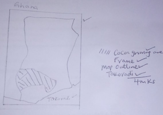
- Draw an outline map of Ghana. (2 mks)
On it show the following:- Cocoa growing area. (1 mk)
- Takoradi port. (1 mk)
-
- Describe Cocoa growing from harvesting to marketing in Ghana. (7 mks)
- The ripe pods are harvested using long sharp knives
- The pods are collected and piled in one central part of the farm
- The pods are split open using sharp knives
- The beans are scooped using hands
- The beans are put in heaps on mats and covered with banana leaves
- Beans are allowed to ferment for 5-6 days during which the juicy pulp drains away
- The fermented beans are washed/cleaned using water
- The cleaned beans are spread on tables covered with mats to dry in the hot sun where they are regularly/frequently turned in order to dry completely and slowly turn brown
- The dry beans are packed in bags and transported/sent to the harvest buying centre
- At the buying centre they are weighed,graded ready for export 7*1=7 marks
NB:Sequence a must to score though some steps may be omitted
- State four problems facing Cocoa farmers in Ghana. (4mks)
- The crop is attacked by pests (Black tea thrip/citrus aphid/cocoa stem borer/soft green scale)/Diseases(swollen shoot disease/monila/witches broom) which destroy crop leading to low yield
- Fluctuation of prices in the world market discourages the farmers
- Low prices paid to farmers for the crop lower their morale
- The strong Hammatan wind destroys the crop
- Inadequate labour during harvesting cause damage to the crop
- Poor/muddy roads make it difficult to deliver the crop on time Any 4*1=4 marks
- Describe Cocoa growing from harvesting to marketing in Ghana. (7 mks)
- You intend to carry out a field study which process wheat in Kenya.
- Name two possible regions in Central Kenya where wheat would be sourced by the factory. (2 mks)
- Mweiga-Nyeri
- Nyandarua 2*1=2 marks
- Give two reasons why content analysis may not be suitable for data collection during the field study. (2 mks)
- It is difficult to verify the accuracy of the available data
- The data may be outdated and therefore irrelevant to current data
- The information may be scanty and may take a lot of time to gather and analyse Any 2*1=2 marks
- What two information would you collect to enable you to achieve the objectives of your study. (3 mks)
- Type of raw materials for the factory
- Sources of power and the raw materials
- Where the factory sells its products
- The sources of labour
- The total number employed by the factory NB:Any other relevant point 2*1=2 marks
- Name two possible regions in Central Kenya where wheat would be sourced by the factory. (2 mks)
- State four physical conditions necessary for the growth of Cocoa in Ghana. (4 mks)
-
- Define the term industrial inertia. (2 mks)
- It is the tendency of an industry to remain at a given place even after the initial factors of its establishment are no longer existing 1*2=2 marks
- Identify one agricultural non-food based industry located in the following town:
- Thika (1 mk)
- Leather tanning
- Tobacco processing
- Sisal processing Any1*1=1 mark
- Webuye (1 mk)
- Thika (1 mk)
- State four reasons for decentralization of industries in Kenya. (4 mks)
- To encourage regional balance in industrial development in the country
- To create employment for many Kenyans in rural areas and promote their standards of living
- To reduce rural-urban migration and hence avoid overcrowding/development of slums
- To allow greater exploitation of local resources by the industries
- To encourage development of roads/social amenities in rural areas 4*1=4 marks
-
- Apart from iron and steel,name three other industries found in Ruhr region of Germany. (3 mks
- Chemical industries/Petro-chemical/fertilizer
- Textile processing industries
- Oil refining
- Electronics
- Food processing/Agricultural based industries
- Service industry/Banking/Insurance
- Engineering/Ship building industry Any 3*1=3 marks
- Explain three factors which influenced the location of iron and steel industry in the Ruhr region of Germany in the 19th century (6 marks)
- Availability of coal, iron ore as well as limestone from the Rhine valley provided raw materials needed in the industry
- River Rhine/Lippe/Wupper/Euscher and its tributaries provided water required for cooling machines in the industry/industrial use
- The region is served by navigable rivers and canal which provide cheap transport for bulky raw materials and furnished product
- Coal and imports petroleum provided water required in the industry
- The total population had acquired skills on iron working/availability of skilled labour and thus formed the foundation of iron and steel industry
- Presence of rich companies and families which provided capital for the development of the country
- The dense and affluent population in Central and Western Europe provided ready market for iron and steel Any 3*2=6 mark
- Apart from iron and steel,name three other industries found in Ruhr region of Germany. (3 mks
- Students from Komothai Secondary School went out for a field study on a nearby fruit processing factory in a nearby town:
- State three reasons why it would be necessary for one of themto visit the factory before the actual field study. (3 mks)
- To get permission from the factory management
- To be able to formulate objectives/hypothesis
- To be able to prepare a working schedule/decide appropriate methods of data collection
- To determine the respodents/resource persons
- To assess the likely problems to be met Any other relevant 3*1=3 marks
- Give three follow up activities they would carry out after the field study. (3 mks)
- Discussing the findings
- Writing a report on their findings
- Analyzing the data collected
- Group leader to present their findings to the class
- Displaying the photographs taken 3*1=3 marks
- State three reasons why it would be necessary for one of themto visit the factory before the actual field study. (3 mks)
- Define the term industrial inertia. (2 mks)
-
-
- What is Agro-forestry . (2 mks)
- Agroforestry is the growing of trees and crops in the same area and at the same time
- State four reasons why afforestation is being encouraged in Kenya. (4 mks)
- To protect the soil from erosion
- Ensure continuous supply of wood fuel/timber/raw materials for paper making
- To protect the water catchment areas/maintain the hydrological cycle/create a micro climate
- To create scenic beauty
- To expand the habitat for wildlife/conservation of wildlife
- To create employment opportunities
- To reduce importation of forest products/foreign exchange 4*1=4 marks
- What is Agro-forestry . (2 mks)
- Explain how the following factors influence the distribution of forests.
- Relief. (2 mks)
- Steep soils have thin soils which discourages the growth of forests/while gentle slopes have deep soils which allow luxuriant growth of forests
- Soils (2 mks)
- Deep/well drained soils support luxuriant growth of forests since they are very fertile/while thin/waterlogged solil discourage growth since they are infertile/lead to death of trees 1*2=2 marks
- Relief. (2 mks)
-
- List three indigenous soft wood trees species in Kenya. (3 mks)
- Podo
- African pencil
- Cedar
- State two physical problems facing forests in Kenya. (2 mks)
- Some forests tree species are affected by pests i.e aphids/diseases leading to their death reducing forest cover
- Prolonged drought caused by failure of rain has led to retarded growth of tree species
- List three indigenous soft wood trees species in Kenya. (3 mks)
-
- Name two major lumbering provinces in Eastern Canada. (2 mks)
- New found land
- Nova Scotia
- Prince Edward Island
- New Brunswick
- Ontario
- Quebec
- State four characteristics of Coniferous forests (4 mks)
- The trees are tall/30-40 metres/straight trunks
- The trees are conical in shape to allow the shedding of snow
- The trees have a very thick bark to protect the trees from frost
- The trees bears cones for seeds which can withstand cold climate
- The trees are evergreen
- Most trees are light in weight hence easy to cut and transport
- Trees have shallow roots allowing them to utilize moisture in top soils
- Trees occur in pure stands 4*1=4 marks
- Discuss forestry in Kenya and Canada under the following sub-heading:
- Transport (2 mks)
- In Canada logs are transported using melt water/skidding over frozen water while in Kenya logs are transported using roads 1*2=2 marks
- Harvesting of trees. (2 mks)
- In Canada harvesting of trees is done in winter/early summer while in Kenya harvesting takes place throughout the year
- In Canada harvesting is done by clear cutting of trees while in Kenya harvesting is dine through selective cutting of trees
- Transport (2 mks)
- Name two major lumbering provinces in Eastern Canada. (2 mks)
-
-
- Study the map of the world provided showing the major fishing grounds and answer the questions that follows:
- Name the fishing ground labelled C. (1 mks)
- North East Atlantic fishing ground 1*1=1 mark
- List three species of fish caught in the fishing ground labelled B. (3 mks)
- Herring
- Salmon
- Tuna
- Bonito
- Sardines
- Name the oceans current labelled D. (1 mk)
- Warm Gulf stream current 1*1=1 mark
- State the influences of the ocean current labelled D on fishing activities. (2 mks)
- The warm current raises the temperature making the coastal region ice free making fishing possible throughout the year
- The warm current converges with the cold Labrador current resulting in cool conditions helping in the growth of planktons
- The meeting of the current with the cold Labrador causes upwelling of water bringing fish food to the surface where it becomes available to the fish 2*1=2 marks
- Name two countries sharing the fishing ground labelled E. (2 mks)
- United States of America
- Canada
NB:Abbreviation should not be accepted 2*1=2 marks
- Name the fishing ground labelled C. (1 mks)
- Explain how the following factors influences fishing in the major fishing grounds:
- Indented coastline (2 mks)
- Indented coasts provide sheltered waters for fish breeding/developments of fishing ports/villages supporting fishing 1*2=2 marks
- Continental shelf (2 mks)
- The continental shelf of these grounds are shallow and broad which support growth of plankton which attracts more fish
- Technology (2 mks)
- The countries bordering the fishing ground have advanced technology with modern vessels/equipment used in deep sea fishing
- Indented coastline (2 mks)
- Describe how Basket method is used in fishing. (5 mks)
- A basket that is funnel shaped to allow easy entry of fish
- A bait is placed inside the basket to attract fish
- The mouth of the basket has no return valve
- The basket is lowered into the water with the mouth facing upstream
- The basket is held into position by the use ropes/sticks to prevent it being swept downstream
- The basket is left in that position for sometimes /overnight to catch fish
- The basket is hauled/removed from the water and emptied
- The basket is reset again for more catch
NB:Sequence must be followed 5*1=5 marks
-
- What is aqua-culture? (2 mks)
- Aquaculture is the practice of fish farming aimed of fish farming aimed at producing high quality fish for sale/family use to earn income/food 1*2=2 marks
- State three reasons why fish farming has been on the increase in Kenya. (3 mks)
- It allows better/maximum land use which has been fragmented due to high population/occupies very small space
- Has led to creation of self-employment hence contributing to income
- Has contributed to meeting the demand for food rich in protein for the family
- It saves on tome/labour since it’s cheap to operate
- Has led to the support of other related industries like net making creating more jobs
- What is aqua-culture? (2 mks)
- Study the map of the world provided showing the major fishing grounds and answer the questions that follows:
Join our whatsapp group for latest updates
Tap Here to Download for 50/-
Get on WhatsApp for 50/-
Download GEOGRAPHY PAPER 2 Marking Scheme - 2017 MURANG'A MOCK EXAMINATION.
Tap Here to Download for 50/-
Get on WhatsApp for 50/-
Why download?
- ✔ To read offline at any time.
- ✔ To Print at your convenience
- ✔ Share Easily with Friends / Students


