
Instructions to candidates
- This paper consists of two Sections; A and B.
- Answer all the questions in Section A.
- Answer question 6 and any other two questions from Section B.
SECTION A: 25 MARKS
Answer ALL questions in this section
-
-
- Define Geography. (2 mark)
- Name two branches of Geography (2 marks)
- State three reasons why it is important to study Geography. (3 marks)
-
-
- Name two breeds of dairy cattle reared in Kenya. (2 marks)
- State two factors which favour dairy farming in Denmark. (2 marks)
-
- Give two types of ground photographs. (2 marks)
- State two limitations of using photographs. (2marks)
- The diagram below shows the occurrence of petroleum on the earth crust. Use it to answer questions (a)and (b)
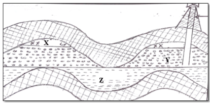
- Name the substance in the areas labeledX, Y and Z. (3marks)
- Give two by products obtained when crude oil is refined. (2marks)
-
- Name two indigenous softwood trees species found in Kenya. (2marks)
- State three effects of deforestation to the environment. (3marks)
SECTION B
Answer question six (6) and any other two Questions from this section.
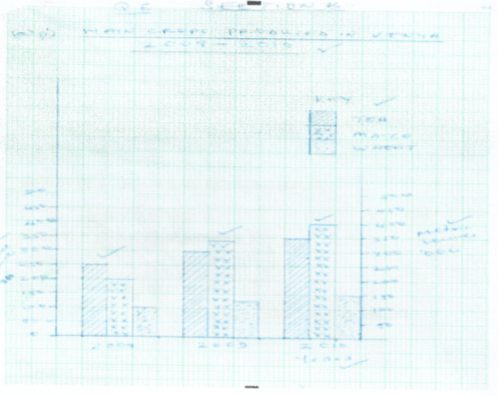
- The table below shows three main crops produced in Kenya in the years 2008-2010 (Amounts in metric tonnes). Use it to answer questions below.
Crop 2008 2009 2010 Maize 200,000 380,000 400,000 Wheat 100,000 130,000 150,000 Tea 250,000 300,000 350,000 -
- Using a scale of 1cm represent 50,000 metric tonnes, draw a comparative bar graph to represent the data above. (8 marks)
- State two advantages of using comparative bar graph. (2 marks)
-
- Name two counties in Kenya where wheat is grown in large scale. (2 marks)
- State three conditions that favour wheat farming in Kenya. (3 marks)
- State four benefits of wheat growing in Kenya. (4 marks)
- Explain three factors that make Canada produce more wheat than Kenya. (6 marks)
-
-
-
- Define the term mining? (2 marks)
- Give four methods of underground mining. (4 marks)
- Explain how the following factors influence mining:
- Level of technology (4 marks)
- Quality of the ore (2 marks)
- Explain four benefits of trona mining at Lake Magadi to Kenya. (8 marks)
- State five negative effects of mining on the environment. (5 marks)
-
- Use the world map below to answer question (a).
-
- Name the ocean currents marked x and Y. (2 marks)
- Name the fishing ground marked Z. (1 mark)
- Explain three physical factors that favour fishing in the fishing ground marked Z. (6 marks)
-
- What is fish farming? (2 marks)
- Name two fish species reared in fish farms in Kenya. (2,marks)
- Explain four problems which are experienced by fish farmers in Kenya. (8 marks)
- Give four uses of fish. (4 marks)
-
-
- State the difference between forest and forestry. (2marks)
- Explain four measures that the Government of Kenya is taking to conserve forest in the country. (8marks)
-
- List any three examples of softwood tree species found in Canada. (3marks)
- State and explain any three factors that have favoured forestry in Canada. (6marks)
- You intend to carry out a field study on forestry within your local environment.
- State three objectives you would formulate for the study. (3marks)
- Give three reasons why it is important to have a working schedule. (3marks)
-
-
- Differentiate between Land Reclamation and Land Rehabilitation. (2marks)
- Give three methods used in reclaiming land in Kenya. (3marks)
-
- State three benefits of reclaiming Yala swamp. (3marks)
- State four physical conditions that favour the establishment of Perkerra Irrigation Scheme. (4marks)
- Explain three problems faced by rice farmers in Mwea Irrigation Scheme. (6marks)
-
- What is a polder? (lmark)
- Outline the stages involved in reclaiming land from the sea in the Netherlands. (6marks)
-
MARKING SCHEME
-
-
- Define Geography. (2 mark)
- It is the study of the interrelationship between physical and human phenomena in relation to the earth surface.
- Name the two branches of Geography (2 marks)
- Physical Geography
- Human Geography
- Practical Geography
- Define Geography. (2 mark)
- State two reasons why it is important to study Geography. (2 marks)
- It provides knowledge about the immediate and the wider environment/it makes us to understand the earth on which we live.
- It creates awareness about the country and the rest of the world / promotes international understanding.
- It promotes awareness on the sustainable use of resources.
- It promotes development of skills and critical thinking.
- It prepares one for career opportunities.
-
-
- Name two breeds of dairy cattle reared in Kenya. (2 marks)
- Guernsey
- Jersey
- Friesian
- Ayrshire
- Zebu swiss brown
- State two factors which favour dairy farming in Denmark. (2 marks)
- well-developed co-operative movement
- Availability of market for dairy produce
- Availability of extension services
- Suitable climate/moderate temperature
- Handy fodder/ pasture
- Advanced technology/specialization
- Mechanization2x 1 = 2 marks
- Name two breeds of dairy cattle reared in Kenya. (2 marks)
-
- Two types of ground photographs.
- Ground close-up photographs
- Ground general view photographs
- Ground oblique photographs (2marks)
- Two limitations of using photographs.
- Vertical aerial photographs are difficult to interpret without special instruments e.g. stereoscopes
- Photographs are expensive to produce
- Cameras need well focusing to avoid blurred images
- Objects that are far away from the camera may not be clear thus leading to wrong interpretation. (2marks)
- Two types of ground photographs.
- The diagram below shows the occurrence of petroleum on the earth crust. Use it to answer questions (a)and (b)
- Name the substance in the areas labeled X, Y and Z. (3marks)
- X – Natural gas/gas
- Y – Oil/crude oil
- Z – Water
- Give two by products obtained when crude oil is refined. (2marks)
- Bitumen/Asphalt/Pitch/Tar,
- Lubricant /Grease,
- Wax,
- Resin/Petrochemicals,
- Sulphur.
- Name the substance in the areas labeled X, Y and Z. (3marks)
-
- Name two indigenous softwood trees species found in Kenya. (2marks)
- Podo
- Juniper
- Bamboo
- Kenya cedar/Red/White cedar
- State three effects of deforestation to the environment. (3marks)
- Cause destruction of water catchment areas
- Lead to extinction of some tree species/loss of biodiversity
- May cause soil erosion
- May cause aridity /desertification
- Name two indigenous softwood trees species found in Kenya. (2marks)
SECTION B
Answer question six (6) and any other two Questions from this section.
- The table below shows three main crops produced in Kenya in the years 2008-2010 (amounts in metric tonnes). Use it to answer questions below.
-
- Using a scale of 1cm represent 50,000 metric tonnes, draw a comparative bar graph to represent the data above. (8 marks)
- State two advantages of using comparative bar graph. (2 marks)
- It gives a clear visual impression
- Values in the same group can be compared easily
- The individual contribution made by the variables in each group can be easily identified
- It is easy to draw/construct
- It is easy to read/interpret
- Using a scale of 1cm represent 50,000 metric tonnes, draw a comparative bar graph to represent the data above. (8 marks)
-
- Name two counties in Kenya where wheat is grown in large scale. (2 marks)
- Nakuru
- Narok
- UasinGishu
- Nyandarua
- State three conditions that favour wheat farming in Kenya. (3 marks)
- Gently sloping land for ease of mechanization
- High altitude (1500 – 2000m) above sea level
- Moderate rainfall (500mm – 1270mm)
- Moderate temperature/warm conditions (15°c – 20°c) for at least three months
- Deep fertile volcanic soils
- Warm dry sunny spell to enhance ripening and harvesting (Any 3x1=3mks)
- Name two counties in Kenya where wheat is grown in large scale. (2 marks)
- State four benefits of whet growing in Kenya. (4 marks)
- Source of income for those involved in the activity
- Source of food to the Kenyan people
- Through wheat farming many are employed either directly or indirectly
- Saves foreign exchange if it was to be imported
- Promotes industrialization in Kenya
- Improvement of roads
- Explain three factors that make Canada produce more wheat than Kenya. (6 marks)
- Canada has extensive tracts of land which has enabled large scale mechanization of wheat
- Canada is a developed country therefore has more capital enabling farmers to sustain production unlike Kenya which has inadequate capital.
- Advanced scientific research in Canada enables the production of higher yielding seeds, better farming tools, seeds, pest control, disease control etc.
- Wheat farmers in Canada specialize in wheat unlike Kenya where farmers practice mixed farming
- There is higher demand for wheat in Canada while in Kenya low demand
- Farmers in Canada have had a long experience in wheat production spanning over centuries unlike Kenya where wheat farming is relatively new/introduced by white settlers (6 marks)
-
-
-
- Define the term mining? (2 marks)
- Mining refers to the process of extracting valuable minerals and fossils fuels on or from the earth’s crust.
- Give four methods of underground mining. (4 marks)
- Deep shaft
- Drilling
- Adit/drift
- Solution
- Define the term mining? (2 marks)
- Explain how the following factors influence mining:
- Level of technology (4 marks)
- Advanced technology has improved mining operations thus leading to high quality /large quantity mineral products.
- High level technology allows for effective exploration of minerals leading to accurate location of minerals.
- Advanced technology boost effectiveness in production hence reducing wastage.
- Quality of the ore (2 marks)
- High grade ores yield more metal thus very economical to mine while low grade ores yield low metal.
- Crude oil with very light and with the least Sulphur is the best quality thus highly preferred than heavy crude with more Sulphur.
- Level of technology (4 marks)
- Explain four benefits of trona mining at Lake Magadi to Kenya. (8 marks)
- Export of soda ash earns foreign exchange to Kenya which is used in foreign trade.
- Trona mining has created employment opportunities to many Kenyans who earn income thus improving their standards of living.
- Development of glass and bottle industry as soda ash provides the main raw material.
- Trona mining has led to development of a tarmac road and railway branch from Konza to Magadi.
- Provision of social amenities such as schools and a hospital thus improving living standards of the local people.
- The Kenyan government (national and county) earns revenue through taxation on the profit of the company.
- The company provides free water to the local people for both domestic and livestock use.
- Trona mining has led emergence and growth of Magadi town
- State five negative effects of mining on the environment. (5 marks)
- The land is left bare with large craters which are ugly/ loss of the beauty of land.
- Heaps of rock waste hinders any other form of land use.
- Clearance of land before exploitation of minerals encourages soil erosion.
- Clearing natural vegetation in an area for mining leads to loss of plant and animal life/loss of biodiversity.
- Open cast mining leads to shortage of land due to displacement of people and land dereliction.
- Dust produced during open cast mining pollutes the atmosphere.
- Large scale blasting of rocks causes instability of basement rocks.
-
- Use the word map below to answer question (a).
-
- Name the ocean currents marked x and Y. (2 marks)
- X- Warm North pacific drift
- Y – Cold Peruvian ocean currents
- Name the fishing ground marked Z. (1 mark)
- North East Atlantic fishing ground
- Name the ocean currents marked x and Y. (2 marks)
- Explain three physical factors that favour fishing in the fishing ground marked Z. (6 marks)
- Extensive continental shelf host a lot of planktons the basic food for fish
- Indented coastlines suitable site for fish breeding/port development
- Rugged landscape not ideal for Agriculture hence fishing is ideal alternative.
- Cool water s favours growth of varieties of fish species.
-
- What is fish farming? (2 marks)
- It is artificial rearing o fish in fish ponds/rice field
- Name two fish species reared in fish farms in Kenya. (2 marks)
- Tilapia
- Trout
- Nile Perch
- Explain four problems which are experienced by fish farmers in Kenya. (8 marks)
- Poor feeder roads-delay transportation of fish to the market.
- Pour feeder roads-delay transportation of fish to the market
- Exploitation by middlemen reduces profit
- Inadequate market due to low purchasing power
- Some cultures despises eating fish hence low market.
- Inadequate capital to expand fish farming.
- What is fish farming? (2 marks)
- Give four uses of fish. (4 marks)
- Food
- Sold to earn income
- Raw material for making feeds
- Alleviates chest problems e.g.cod liver oil
-
-
- Forest is a continuous and extensive growth of trees covering a large track of land while forestry is a science of developing or cultivating forests/ science of planting, caring and using trees .(2marks)
-
- Getting forest areas to reduce encroachment of public
- Creating public awareness through mass media on the importance of conserving forests / forest resources
- Enacting laws to prohibit the cutting of trees without a license
- Establishing NEMA/ ministry of environment and natural resources to coordinate environment management and conservation activities
- Setting aside national tree planting day to encourage people to plant more trees
- Advising people to practice agroforestry so as to avoid cutting trees from the forests
- Employing forest guards to protect forests from fires /other illegal human activities
- Encouraging recycling of papers / wood-based products / use of other resources of energy to reduce the demand of trees
- Carrying out research through KEFRI and ICRAF for controlling pests and diseases .(8marks)
-
- Spruce
- Douglas
- Fir
- Pine (any 3x1=3mks)
- The low temperatures experienced discourages settlements and other land use forms making forest the only alternative.
- There is ready market in Canada and the neighboring USA for the forest products
- The ruggedness of the landscape and thin soil discourages agriculture therefore most of the mountain’s slopes are under forests
- Valley bottoms along the coast provide sides for the paper mills
- High precipitation throughout the year promoted forest growth
- The coastal location also favors the exportation of timber products from the mills
- Rivers such as Ottawala and Frazer provide cheap means of water transport
- There are many rivers with waterfalls for instance river Ottawala which provide constant volume of water used to generate hep for use in industries such as pulp and paper industries. ( Stating alone earns 1 mk but state and explain earns 2mks i.e
any 3x2=6mks)
- Spruce
-
-
- To find out the types of tree species in the forest
- To identify characteristic of the forest
- To identify factors influencing forest distribution in the area
- To determine the main causes of forest destruction I the area
- To identify the methods that can be used to conserve the forest.(any 3x1=3mks)
-
- Gives ample time for each activity so that none is forgotten
- Reduced the tendency to waste time and forces the research team to work within allocated time of the project
- Provides estimate of time required for field study
- Provides basis for evaluating field work while still in progress
- Maintains the scope of field work(any 2x1=2mks)
-
-
-
- Differentiate between Land Reclamation and Land Rehabilitation. (2marks)
- Land reclamation is a process by which unproductive land such as deserts, mash or swamp is converted into a land fit for cultivation while/whereas Land rehabilitation is the restoration of land that has been ruined through man’s negligence to its former reputation or good condition.
- Give three methods used in reclaiming land in Kenya. (3 marks)
- Irrigating dry land.
- Draining of swamps
- Adding manure to infertile soils
- Introducing drought resistant crops
- Planting of trees/Afforestation
- Tse-tse fly control
- Differentiate between Land Reclamation and Land Rehabilitation. (2marks)
-
- State three benefits that result from reclaiming land. (3marks)
- It has helped resettle landless people
- The scheme has opened productivity in former wasteland
- Tenants generate income from horticultural farming which has helped raise their living standards
- Creation of employment for the local people.
- State four physical conditions that favour the establishment of Perkerra Irrigation Scheme. (4marks)
- Steady supply of water from R.perkerra used for irrigation
- Gently sloping land makes water to flow by gravity
- Presence of clay loam soil swhich is rich in calcium/ph osphate enables growth of variety crops
- The area was receiving inadequate rainfall which necessitated irrigation
- State three benefits that result from reclaiming land. (3marks)
- Explain three problems faced by rice farmers in Mwea Irrigation Scheme. (6mks)
- Stagnant pools of water have led to water borne diseases e.g bilharzias and malaria which weakens farmers hence lowering their productivity.
- Siltation of canals which calls for regular dredging which is expensive.
- High rates of evaporation has led to salinisation of soils.
- Pest like quelea destroy crop and reduce yield thereby reducing farmers income
- Mismanagement of funds has led to delayed payments to farmers.
-
- What is a polder? (1mark)
- Part of the low lying land covered by sea water is enclosed using strong walls/ ring dykes
- Outline the stages involved in reclaiming land from the sea in the Netherlands. (6 mks)
- Protective dykes were constructed to enclose the part of the sea to be enclosed
- Ring canals are constructed to lead water to pumping station.
- The water is pumped out using windmills/dieselpumps/electricity pumps.
- Ditches are then dug to drain the excess water from the enclosed land P Chemicals are added to the soil to reduce salinity /fresh water is pumped into the enclosed land to reduce sality.
- Oats, rye and sugar beets are planted to improve the PH of the soil and reduce the land salinity further.
- The land is left to dry
- Land was put to use- agric, settlement, industry
- What is a polder? (1mark)
-
Join our whatsapp group for latest updates
Tap Here to Download for 50/-
Get on WhatsApp for 50/-
Download Geography Paper 2 Questions and Answers - Sunrise Pre Mock Exams 2023.
Tap Here to Download for 50/-
Get on WhatsApp for 50/-
Why download?
- ✔ To read offline at any time.
- ✔ To Print at your convenience
- ✔ Share Easily with Friends / Students