
-
- Name two subdivisions of human geography. ( 2 marks)
- Define the following terms ).
- Geomorphology: (2Marks)
- Climatology: ( 2Marks)
-
- Draw a diagram of the internal structure of the Earth. (1mk)
On it label the following parts :- Sima. (1mk)
- Hydrosphere. (1mk)
- Asthenosphere. (1mk) - Name the zone of discontinuity that occurs between the crust and the mantle.(1mk)
- Outline three characteristics of the Sial. (3mks)
- Give two reasons why the interior of the Earth is still very hot. (2mks)
- Draw a diagram of the internal structure of the Earth. (1mk)
-
- What is a Land Breeze (2mks)
- Give three ways in which sea breeze influence the adjacent land. ( 3 marks)
- What is a Stevenson screen ( 2 marks)
- Name three instruments that are placed in Stevenson screen (3 marks )
-
- State three effects of the rotation of the earth ( 3 marks )
- State four proofs that the earth is spherical ( 4 marks )
-
- Name four layers of the atmosphere ( 4 marks )
- Give two local winds that are found in Kenya (2marks)
- State three conditions necessary for formation of dew (3marks)
-
-
- What is a map? (2marks)
- State three uses of a map. ( 3marks)
- State three types of scale. (3mks)
- Convert the following scale into a statement scale. (2mks)
1:250,000
-
-
- List the three types of Norths on a topographic map. (3mks)
- State three examples of marginal information on a map. ( 3mks)
-
- State three methods used to calculate area of an irregular feature in a map. (3marks)
- State two Forces that influenced the oblate spheroid of the earth (2mks)
- If the local time in Kampala ,Uganda 30°E is 9.00pm ,what will be the time in Accra Ghana 0° (2mks)
-
- What is fieldwork? (2mks)
- List three main types of fieldwork. (3mks)
- Outline four methods of collecting during field study. (4mks)
- Give four characteristics of a good sketch map. (4mks)
-
- Differentiate between primary data and secondary data. (2mks)
- List two sources of secondary data. (2mks)
- A student from your class picked the following numbers at random:
27,40,41,21,92,75,21,41,20,41,23.- Calculate the mean of the data. (2mks)
- Determine the median value of the data. (2mks)
- Determine the modal value of the data. (2mks)
-
- Apart from planets give four other heavenly bodies. ( 4mks)
- Give three advantages of simple bar graph (3Mks)
- State three methods of collecting data (3Mks)
MARKING SCHEME
-
- Name two subdivisions of human geography.
- Historical geography
- Political geography
- Medical geography
- Economic geography
- Population geography
- Industrial geography
- Agricultural geography
- Transport geography
- (Any 2 × 1 = 2 marks)
- Define the following terms
- Geomorphology: The study of landforming processes (2Marks)
- Climatology: the study of climate ( 2Marks)
-
- Draw a diagram of the internal structure of the Earth. (1mk)
On it label the following parts :- Sima. (1mk)
- Hydrosphere. (1mk)
- Asthenosphere. (1mk)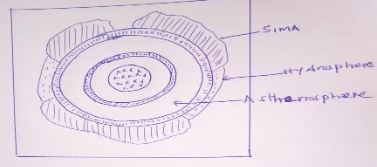
- Name the zone of discontinuity that occurs between the crust and the mantle.(1mk)
- Mohorovisic/Moho discontinuity .( 1mk)
- Outline three characteristics of the Sial. (3mks)
- It forms the continental rock.
- Comprises of two minerals, silica and aluminium.
- It’s usually less dense than sima.
- Has an average density of 2.7gms/cc.
- The rocks are mainly granitic.
- Give two reasons why the interior of the Earth is still very hot.(2mks)
- The original heat is still being retained at the centre.
- The crustal rock applies a lot of pressure to the centre generating heat.
- Presence of radioactivity at the centre where nuclear fission takes place generating heat.
- Draw a diagram of the internal structure of the Earth. (1mk)
- Name two subdivisions of human geography.
-
- What is a Land Breeze (2mks)
- Refers to a mass of cool air blowing from the land to the sea during the night (2mks)
- Give three ways in which sea breeze influence the adjacent land.
- It lowers the temperature of the adjacent land.
- It may increase rainfall
- It may increase relative humidity
- It moderates diurnal range of temperature
- It may lead to convectional rainfall. ( Any 3x1 = 3 marks)
-
- What is a Stevenson screen
- Is a white wooden box in which metrological instruments are kept in a weather station (1x2= 2 marks)
- Name three instruments that are placed in Stevenson screen
- Maximum thermometer
- Minimum thermometer
- Six’s thermometer
- Hydrometer (Any 3 x1=3 marks )
- What is a Stevenson screen
- What is a Land Breeze (2mks)
-
- State three effects of the rotation of the earth
- Causes day & night
- Causes differences of one hour between
- It causes deflection of winds ocean tides
( 3 x 1= 3 marks)
- State four proofs that the earth is spherical
- Circumnavigation of the earth along a straight path leads one of starting point
- The gradual appearance of the ship approaching the shock
- The difference times during which sun rises and sets in different parts of the world
- The circular shadow cast by the earth during a lunar eclipse
- All other planets are circular
( Any 4 x1=4 marks)
- State three effects of the rotation of the earth
-
- Name the layers of the atmosphere
- Troposphere
- Stratosphere
- Mesosphere
- Thermosphere/ Ioriosphere
- Exosphere ( Any 4 x1=4 marks )
- Give two local winds that are found in Kenya
- Anabatic winds
- Katabatic winds
- Sea breeze
- Land breeze
(2 x 1 = 2marks)
- State three conditions necessary for formation of dew.
- Daytime should be warm.
- The air should be calm
- Low temperature below dew point
- Cloudless nights. (Any3 x 1 = 3marks)
- Name the layers of the atmosphere
-
-
- What is a map?
- It is a representation of a part of the whole of the earth surface on a flat surface usually drawn to scale. (2marks)
- State three uses of a map.
- Sketch maps are used to summarize information for easy reference
- They can be used for locating other countries.
- They can be used for comparing sizes of countries.
- Used for locating climatic regions of differently parts of the world.
- Give distribution of vegetation on the earth surface.
- Help travellers to find their way.
- Used to calculate distance and area of a certain place.
- Used to locate physical features like land forms. (Any 3 x 1= 3marks)
- What is a map?
- State three types of scale.
- Statement scale
- Linear scale
- Ratio scale R/F ( 3 x 1= 3marks)
- Convert the following scale into a statement scale.(2mks)
- 1/250,000
250,000 cm x 1 km = 2.5 km.
100,000 cm
1cm to 2.5km. (2Marks)
- 1/250,000
-
-
- List the three types of North on a topographic map.
- True North
- Magnetic North
- Grid North (3 x 1= 3marks)
- State three examples of marginal information on a map.
- map name
- Sheet title
- Grid system numbers
- Latitude and longitude
- Compass direction/ magnetic variation
- Scales
- Publisher and copy right
- Map series
- Sheet number or sheet index. (Any 3 x 1= 3marks)
-
- State three methods used to calculate area of an irregular feature in a map.
- Use of rectangles and triangle.
- Use of strips
- Use of grid squares (Any 3 x 1= 3marks)
- State two Forces that influenced the oblate spheroid of the earth
- Centripetal force
- Centrifugal force
- Gravitational force (2x1=2mks)
- If the local time in Kampala ,Uganda 30°E is 9.00pm ,what will be the time in Accra Ghana 0° (2mks)
Difference in degrees 30°– 0° = 30°
Time difference 30 x 4 = 120hour ÷ 60 = 2 hrs
Time in Accra 9.00 pm – 2hrs = 7.00pm (2x1=2mks)
- State three methods used to calculate area of an irregular feature in a map.
- List the three types of North on a topographic map.
-
- What is fieldwork? (2mks)
- Fieldwork is an activity that involves seeing and using the surrounding environment as a laboratory for teaching and learning geography. (2 x 1= 2mks.)
- List three main types of fieldwork.(3mks)
- Field study
- Field excursion
- Fieldwork research. (3 x 1 = 3mks)
- Outline four methods of collecting data during field study.
- Direct observation.
- Interviewing the respondent.
- Administering questionnaires.
- Collecting samples.
- Counting.
- Taking photographs.
- Carrying out experiments.
- Extracting from secondary sources. ( Any 4 x1 =4 Marks)
- Give four characteristics of a good sketch map. (4mks)
- It should have a title.
- It should have a key.
- It should have a compass direction.
- It should be enclosed in a frame.
- It should be neat and clear. (Any 4 x 1 = 4 Marks)
- What is fieldwork? (2mks)
-
- Differentiate between primary and secondary data. (2marks)
- Primary data include all the facts and figures collected as first hand from the field while secondary data refers to facts and figures collected and recorded in textbooks/other written materials. ( 2Marks)
- List two sources of secondary data.
- Textbooks.
- Statistical abstracts.
- Newspapers/Magazines.
- Census report.
- Geological reports. (Any 2 x 1 =2Marks)
- A student from your class picked the following numbers at random:
27,40,41,21,92,75,21,41,20,41,23.- Calculate the mean of the data. (2mks)
27 + 40+41+21+92+75+21+41+20+41+23 = 442 = 40.18 (2 Marks)
11 11 - Determine the median value of the data. (2mks)
20,21,21,23,27,40,41,41,41,75,92.
Median is 40. ( 2mks) - Determine the modal value of the data.(2mks)
20,21,21,23,27,40,41,41,41,75,92.
Modal value is 41. ( 2mks.)
- Calculate the mean of the data. (2mks)
- Differentiate between primary and secondary data. (2marks)
-
- Apart from planets give four other heavenly bodies
- Asteroid
- Meteors
- Meteorites
- Comets
- Satellites ( Any 4 x 1 = 4marks)
- Give three advantages of simple bar graph
- It is easy to draw
- It is easy to interpolate and read
- It gives a good clear vision
- It is easy to compare different quantities ( Any 3 x 1 = 3Marks)
- State three methods of collecting data
- Administering questionnaire
- Direct observation
- Taking interview
- Taking photographs (Any 3 x 1 = 3Marks)
- Apart from planets give four other heavenly bodies
Join our whatsapp group for latest updates
Tap Here to Download for 50/-
Get on WhatsApp for 50/-
Download Geography Questions and Answers - Form 1 Term 3 Opener Exams 2023.
Tap Here to Download for 50/-
Get on WhatsApp for 50/-
Why download?
- ✔ To read offline at any time.
- ✔ To Print at your convenience
- ✔ Share Easily with Friends / Students


