
SECTION A: (40 MARKS)
-
- what is a Stevenson screen ( 2mks)
- Name three instruments that are placed in Stevenson screen (3mks)
- State three effects of the rotation of the earth (3mks)
- State four proofs that the earth is spherical (4mks)
- Name the layers of the atmosphere (4mks)
-
- Name two scales used to measure the intensity of an earthquake (2mks)
- List five causes of earthquake (5mks)
-
- Outline any four uses of maps (4mks)
- Give any three marginal information found in topographical map (3mks)
-
- Give three forces that are responsible for lateral earth movement (3mks)
- Name two types of tectonic plate boundaries (2mks)
-
- What is folding (2mks)
- Use the diagram below to answer the questions that follow
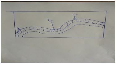
Name the part labeled- B-
- C-
- D-
SECTION B :60 marks : Answer all questions in this section
-
- Give 2 factors that are considered when classifying clouds (2mks)
- Give four reasons why weather forecasting is important (4mks)
- Suppose you visited a weather station a field study on weather
- Give four methods you would use to record data (4mks)
- State five advantages of studying weather through field work (5mk)
- State five factors that influences climate (5mks)
-
-
- What is a mineral (2mks)
- Give four characteristics of minerals (4mks)
-
- What is metamorphic rocks (2mks)
- State 4 characteristics of igneous rock (4mks)
- Outline the significance of rocks to the economy of Kenya (8mks)
-
-
- Name four active volcanoes in Kenya (4mks)
- Describe the formative of a composite volcano (4mks)
- Explain six ways in which volcanic features influence human activities (12mks)
MARKING SCHEME
-
- what is a Stevenson screen
- Is a white wooden box in which metrological instruments are kept in a weather station (1x2= 2 marks)
- Name three instruments that are placed in Stevenson screen
- Maximum thermometer
- Minimum thermometer
- Six’s thermometer
- Hydrometer (Any 3 x1=3 marks )
- what is a Stevenson screen
- State three effects of the rotation of the earth
- Causes day & night
- causes differences of one hour between
- It causes deflection of winds ocean tides ( 3 x 1= 3 marks )
- State four proofs that the earth is spherical
- Circumnavigation of the earth along a straight path leads one of starting point
- The gradual appearance of the ship approaching the shock
- The difference times during which sun rises and sets in different parts of the world
- The circular shadow cast by the earth during a lunar eclipse
- All other planets are circular ( Any 4 x1=4 marks )
- Name the layers of the atmosphere
- Troposphere
- Stratosphere
- Mesosphere
- Thermosphere/ Ioriosphere
- Exosphere ( Any 4 x1=4 marks )
-
- Name two scales used to measure the intensity of an earthquake
- The Rossi-sorrel scale
- The mercelli scale ( 2 x 1 =2marks )
- List five causes of earthquake
- Gravitational pressure
- Collision of tectonic plates
- Energy release in the mantle
- Isotonic adjustment
- Violent volcanic emption
- Nuclear explosions
- Adjustment along fault lines
- building reservoirs
- Magma movement within the crust ( Any 5x1=5marks )
- Name two scales used to measure the intensity of an earthquake
-
- Outline any four uses of maps
- To locate places/landforms on the earth’s surface
- To determine the size of a particular location
- To provide different information about places eg. Climate vegetation
- used by travelers to find direction to a particular place
- used to summarize information quickly for future reference ( Any 4x1=4marks )
- Give any three marginal information found in topographical map
- map series
- sheet index number
- Sheet name/ title
- The scale
- Edition
- Copyright & publisher
- The key
- Grid system numbers
- Latitudes & longitudes
- Compass direction
- Index to adjusting sheets
- Administrations boundaries ( Any 3 x 1=3 marks )
- Outline any four uses of maps
-
- Give three forces that are responsible for lateral earth movement
- Tension force
- Compression
- tear/ shear force ( 3x1=3 Marks )
- Name two types of tectonic plate boundaries
- Divergence/ extension/ constructive
- converging/ compression/ destructive
- Transform/ conservative ( 2x1= 2marks)
- Give three forces that are responsible for lateral earth movement
- What is folding
- Process in which crustal rocks are distorted by compressional forces causing them to bend upwards and downwards ( 2Marks)
- Use the diagram below to answer the questions that follow
Name the part labeled- B- Limb
- C-Anticline
- D- Syncline ( 3 x 1=3 marks )
- What is folding
SECTION B : 60 marks
-
- Give 2 factors that are considered when classifying clouds
- Height
- Shape/form
- Appearance ( Any 2 x 1= 2Marks )
- Give four reasons why weather forecasting is important
- Help the farmer to plan their farming activities
- It influence design of houses guides in the timing of sporting tourism activities
- It guides in landing & taking it of aircrafts
- it guides fishing activities
- It guide sporting activities (Any4 x 1 = 4mks)
- Suppose you visited a weather station a field study on weather
- Give four methods you would use to record data
- Filming/ video tapping/ taking photographs
- Observation
- interviewing
- Reading from secondary sources
- Administering questionnaires
- Taking measurements
- Reading instruments (Any 4 x 1 = 4 Mks)
- State five advantages of studying weather through field work
- It enables students to collect first hand information
- It enables learner to learn how to use weather instruments
- It enables students to apply the knowledge learned in the classroom
- It make learning real
- It provides detailed/broad learning
- It enhances visual memory learning ( Any 5 x 1= 5marks )
- Give four methods you would use to record data
- State five factors that influences climate
- Altitude
- Configuration of coastline in relation to prevailing wind
- Aspect
- Latitude
- Distance from the ocean
- Ocean currents
- Wind & air massing
- Human activities ( Any 5 x1=5 Marks )
- Give 2 factors that are considered when classifying clouds
-
-
- what is a mineral
- It is an inorganic substance with definite chemical composition at or on beneath the earth surface (2 Marks)
- Give four characteristics of minerals
- Have different degree of hardness
- Can be opaque, transparent translucent
- Minerals have tenacity ability to with stand tearing
- Minerals have different texture
- what is a mineral
-
- What is metamorphic rocks
- Rock formed when original igneous/ sedimentary rock is subjected intense heat or pressure (2mks)
- State four characteristics of igneous rock
- Rock form no crystals
- Fined grained
- Form on the earth’s surface
- They form from cooling & solidification of lava ( 4 x 1=4 Marks)
- What is metamorphic rocks
- Outline the significance of rocks to the economy of Kenya
- Some rocks unique features that attract tourist
- Some sedimentary rocks contain fossils fuel which is a source of energy
- Some rock act a storage for water which can be supplied for domestic & industrial use
- Rocks are exploited to earn income eg in quarries
- Some rocks contain minerals which exploited for income (Any 4 x 2=8 Marks)
-
-
- Name four active volcanoes in Kenya
- Logonot
- Teleki
- Likaiyu
- Suswa
- Menengai
- Homahills ( Any 4x1=4mks )
- Describe the formative of a composite volcano
- It is made up of alternative layers of pyroclasts and lava
- It is formed when successive vent eruptions occur. The volcano begins with each eruption with great violence forming layers of ash
- Lava pass through the main pipe and exits through the crater
- a parasitic cone may develop on the side of the volcano composite
- Volcano has steep slopes ( Any 4x1= 4 Marks)
- Explain Six ways in which volcanic feature influence human activities
- Volcanic highlands/ mountain are sources of rivers which provide water for domestic & agriculture/ industrial use
- Volcanic rocks weather to form fertile volcanic soils which support agriculture
- Volcanic rocks are important building materials in the construction industry
- Volcanic features are tourist attractions which promote tourist industry
- Volcanic features such as steam jets and geysers are harnessed to provide geothermal power
- Volcanic mountains/ highlands have forests which provide valuable timber used in building & construction industries
- Volcanic highlands/ mountains modify temperature making them attractive to human settlements ( Any 6 x 2= 12mks )
- Name four active volcanoes in Kenya
Join our whatsapp group for latest updates
Tap Here to Download for 50/-
Get on WhatsApp for 50/-
Download Geography Questions and Answers - Form 2 End Term 2 Exams 2023.
Tap Here to Download for 50/-
Get on WhatsApp for 50/-
Why download?
- ✔ To read offline at any time.
- ✔ To Print at your convenience
- ✔ Share Easily with Friends / Students


