
INSTRUCTIONS
- Answer all the questions
SECTION A
- Define the following terms:
- Geography (2 mks)
- Orbit (2 mks)
-
- Differentiate between longitudes and latitudes. (2 mks)
- Name two forces responsible for the formation of rift valleys. (2 mks
-
- State three characteristics of a Stevenson Screen. (3 mks)
- Name two types of high clouds. (2 mks)
-
- When the local time at Kabale (30°E) is noon, what is the local time at Wajir (40°E)? (3 mks)
- List down three methods of representing relief on topographic maps. (3 mks)
-
- Give three examples of igneous rocks. (3 mks)
- State three characteristics of sedimentary rocks. (3 mks)
SECTION B
- The table below shows petroleum production in thousand barrels per day for countries in Middle East in April 2006. Use it to answer the questions that follow
Country Production in ‘000’ barrels Iran 3800 Kuwait 2550 Qatar 800 Saudi Arabia 9600 Unted Arab Emirates 2500 Iraq 1900 -
- What is the difference in production between highest and lowest producer? (2 mks)
- What is the total amount of petroleum produced in April 2006 in the Region? (2 mks)
- Calculate the average petroleum production per day for the region in month of April (2 mks)
- Draw a divided rectangle 14cm long to represent the above data. (8 mks)
- State four factors that influence the exploitation of minerals. (4 mks)
- State four benefits of petroleum to the economies of Middle East countries. (4 mks)
- State three uses of soda ash. (3 mks)
-
-
-
- What is folding? (2 mks)
- State three factors that influence folding. (3 mks)
-
- Name three fold mountains outside Africa. (3 mks)
- Name four types of folds. (4 mks)
- Explain four economic importance of folding. (8 mks)
-
-
-
- What is derived vegetation? (2 mks)
- State four characteristics of equatorial rain forest. (4 mks)
-
- Explain three adaptation characteristics of desert vegetation. (6 mks)
- Give three reasons why there is no vegetation on top of Mt. Kenya. (3 mks)
-
-
-
- Differentiate between weather and climate. (2 mks)
- List down three elements of weather that can be recorded in a school weather station. 3 mks
- Your class intends to carry out a field study in the nearest weather station.
- State three preparation you would make for the study. (3 mks)
- Give three methods that you would use to record the data. (3 mks)
- Name any four instruments you are likely to observe in the weather station. (4 mks)
-
MARKING SCHEME
SECTION A
- Define the following terms:
- Geography
- Geography is the study of the earth as the home of humankind /man. 1 x 2 = 2 mks
- Orbit
- Is the path in the space which a planet or any other heavenly body follows as it revolves round the sun or round another heavenly body. 1 x 2 = 2 mks
- Geography
-
- Differentiate between longitudes and latitudes.
- Latitudes are imaginary lines drawn on the globe or on a map to show how far north or south a place is from the equator while longitudes are imaginary lines drawn on the globe or on a map showing how far east or west a place is from the prime Meridian/Greenwich meridian. 1 x 2 = 2 mks
- Name two forces responsible for the formation of rift valleys.
- Tension force
- Compression force 2 x 1 = 2 mks
- Differentiate between longitudes and latitudes.
-
- State three characteristics of a Stevenson screen.
- It should be painted white.
- It should have insulated roof.
- It should have wooden louvered sides.
- It should be raised to a height of about 121cm above the ground.
Any 3 x 1 = 3 mks
- Name two types of high clouds.
- Cirrus
- Cirro-stratus
- Cirro-cumulus 2 x 1 = 2 mks
- State three characteristics of a Stevenson screen.
-
- When the local time at Kabale (30oE) is noon, what is the local time at Wajir (40oE)?
Difference in degrees of longitude is:
40° − 30° = 10° √
10° ×4=40 minutes √
Time 12.00+40=12.40 p.m. √ 3 x 1 = 3 mks - List down three methods of representing relief on topographic maps.
- Contours
- Form lines
- Hachures
- Spot heights
- Trigonometrical stations
- Hill shading
- Coloring/layer tinting
- Cliff and rock drawing Any 3 x 1 = 3 mks
- When the local time at Kabale (30oE) is noon, what is the local time at Wajir (40oE)?
-
- Give three examples of igneous rocks.
- Granite
- Gabbro
- Diorite
- Syenite
- Quartz
- Rhyolite
- Trachyte
- Andefite
- Dolerite
- Basalt
- Porphyry Any 3 x 1 = 3 mks
- State three characteristics of sedimentary rocks.
- They are stratified.
- They contain fossils.
- They are non-crystalline.
- They are formed from sediments got from pre-existing rocks, plants and animal remains. Any 3 x 1 = 3 mks
- Give three examples of igneous rocks.
SECTION B
- The table below shows petroleum production in thousand barrels per day for countries in the Middle East in April 2006. Use it to answer the questions that follow.
Country Production in ‘000’ barrels Iran 3800 Kuwait 2550 Qatar 800 Saudi Arabia 9600 United Arab Emirates 2500 Iraq 1900 -
- What is the difference in production between the highest and the lowest producer?
9600 – 800 = 8,800,000 barrels 2 mks - What is the total amount of petroleum produced in April 2006 in the region?
21,150,000 barrels 2 mks - Calculate the average petroleum production per day for the region in the month of April.
21,150,000 ÷ 30 =705,000 barrels 2 mks
- What is the difference in production between the highest and the lowest producer?
- Draw a divided rectangle 14cm long to represent the above data.
Length of segments:
Iran 3800 ×14=2.5cm
21,150
Kuwait 2550 ×14=1.7cm
21,150
Qatar 800 ×14=0.5cm
21,150
Saudi Arabia 9600 ×14=6.4cm
21,150
United Arab Emirates 2500 ×14=1.7cm
21,150
Iraq 1900 ×14 = 1.3cm
21,150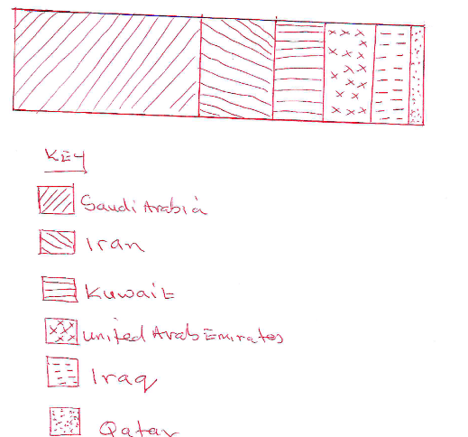
Calculations 6 x 1/2 = 3 mks
Segments 6 x 1/2 = 3 mks
Key = 2 mks
Total 8 mks -
- State four factors that influence the exploitation of minerals.
- Mode of occurrence
- Quality of the ore
- Cost of mining
- Level of technology
- Availability of market
- Government policy/political influence
- Availability of transport facilities Any 4 x 1 = 4 mks
- State four benefits of petroleum to the economies of Middle East countries.
- They earn foreign exchange from exporting crude oil.
- Petroleum industry provides employment to many people in those countries.
- Growth of towns e.g., Dubai
- Development of infrastructure e.g., roads, railways, airports etc.
- Development of social amenities in the mining regions e.g., schools, health facilities etc. Any 4 x 1 = 4 mks
- State three uses of soda ash.
- It is used as raw material for making glass.
- It is used in making detergents.
- It is used in paper industries.
- It is used in desulphurizing steel.
- It is used as water softener/water treatment.
- It is used in petroleum refining. Any 3 x 1 = 3 mks
- State four factors that influence the exploitation of minerals.
-
-
-
- What is folding?
- Folding is the bending of rocks in the earth’s crust. 1 x 2 = 2 mks
- State three factors that influence folding.
- Type of rocks
- The intensity of compressional forces
- Amount of temperature within the rocks 3 x 1 = 3 mks
- What is folding?
-
- Name three fold mountain outside Africa.
- Andes
- Rockies mountain
- Alps mountain
- Himalayas mountain
- Appalachian mountain Any 3 x 1 = 3 mks
- Name four types of folds
- Simple fold/symmetrical/isoclinal
- Asymmetrical fold
- Overfold
- Recumbent fold
- Nappe/overthrust fold\anticlinorium.
- Synclinorium complex Any 4 x 1 = 4 mks
- Name three fold mountain outside Africa.
- Explain four economic importance of folding.
- Fold mountains are catchment areas that provide water for domestic/industrial/irrigation/H.E.P.
- Fold mountains attract rainfall that support agriculture.
- Forests found on fold mountain slopes provide valuable timber used in building and construction.
- Some fold mountains have valuable mineral deposits e.g., coal and petroleum for mining.
- Fold mountains form beautiful sceneries that attract tourists thus earning foreign exchange. Any 4 x 2 = 8 mks
-
-
-
- What is derived vegetation?
- This is vegetation that is in the process of recovering from man’s disturbance but has yet to reach a new climax.
- State four characteristics of equatorial rain forest.
- Trees form distinct canopies.
- Trees are tall, smooth barked and with no branches at the lower sections.
- Tree trunks are commonly buttressed.Trees have broad leaves.
- Varied number of tree species/mixed tree species Any 4 x 1 = 4 mks
- What is derived vegetation?
-
- Explain three adaptation characteristics of desert vegetation.
- Tree have long tap roots to tap water from the lower zones of the soil.
- Trees are umbrella shaped to provide shade thus reducing the rate of evaporation around the stem.
- Some plants shed their leaves during dry season to reduce loss of water through transpiration.
- Some plants have thick barks and leaves for storing water.
- Some plants have small leaves/needlelike leaves to reduce loss of water through transpiration.
- Some plants produce seeds which lie dormant for a long time and germinate when the rainfalls.
- Some plants have very short growth cycle.
- Some plants are hairy and thorny to protect them from damage by animals. Any 3 x 2 = 6 mks
- Give three reasons why there is no vegetation on top of Mt. Kenya.
- Temperatures are too low to support vegetation.
- The surface is bare rock with no soil to support vegetation.
- Water is always frozen and therefore not available to plants.
- The surface is permanently covered by ice. Any 3 x 1 = 3 mks
- Explain three adaptation characteristics of desert vegetation.
-
-
-
- Differentiate between weather and climate.
- Weather is the condition of the atmosphere of a given place at a specific time or over a short period of time while climate is the average weather condition of a given place over a long period of time usually 30 – 35 years.
1 x 2 = 2 mks
- Weather is the condition of the atmosphere of a given place at a specific time or over a short period of time while climate is the average weather condition of a given place over a long period of time usually 30 – 35 years.
- List down three elements of weather that can be recorded in a school weather station.
- Temperature
- Humidity
- Air pressure
- Precipitation
- Wind
- Sunshine
- Cloud cover Any 3 x 1 = 3 mks
- Differentiate between weather and climate.
- Your class intends to carry out a field study in the nearest weather station.
- State three preparations you would make for the study.
- Seeking permission from the relevant authorities
- Formulating objectives and hypothesis
- Preparing a working schedule
- Dividing the participants/students into groups
- Conducting pre-visit/reconnaissance
- Identify and collecting the relevant tools and equipment.
- Preparing a questionnaire Any 3 x 1 = 3 mks
- Give three methods that you would use to record the data.
- Tallying
- Note taking.
- Tape recording
- Labeling samples
- Filling questionnaire
- Taking photographs
- Field sketching Any 3 x 1 = 3 mks
- Name any four instruments you are likely to observe in the weather station.
- Thermometer
- Rain gauge
- Hygrometer
- Barometer
- Wind vane
- Sunshine recorder
- Evaporimeter
- Anemometer Any 4 x 1 = 4 mks
- State three preparations you would make for the study.
-
Join our whatsapp group for latest updates
Tap Here to Download for 50/-
Get on WhatsApp for 50/-
Download Geography Questions and Answers - Form 2 End Term 3 Exams 2023.
Tap Here to Download for 50/-
Get on WhatsApp for 50/-
Why download?
- ✔ To read offline at any time.
- ✔ To Print at your convenience
- ✔ Share Easily with Friends / Students


